Uncategorized

What is the Icelandic Hotspot?

According to the model of convection rolls presented here, volcanic anomalies develop due to the effect of convection rolls effect on the tectonic plates. The complex pattern of currents underneath Iceland, along with the tectonic drift, causes the exceptional activity level of volcanoes and geothermal areas.

Approximate location of the Icelandic ‘hotspot’.

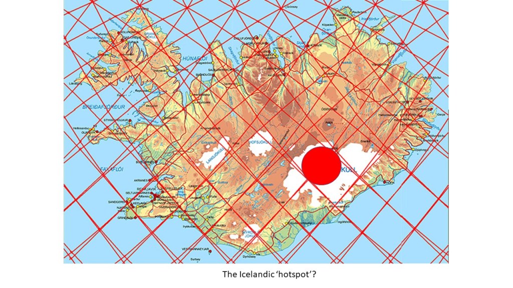
According to relevant articles, the hotspot should be found underneath the western part of the glacier Vatnajökull. It can be read about here: https://en.wikipedia.org/wiki/Iceland_hotspot

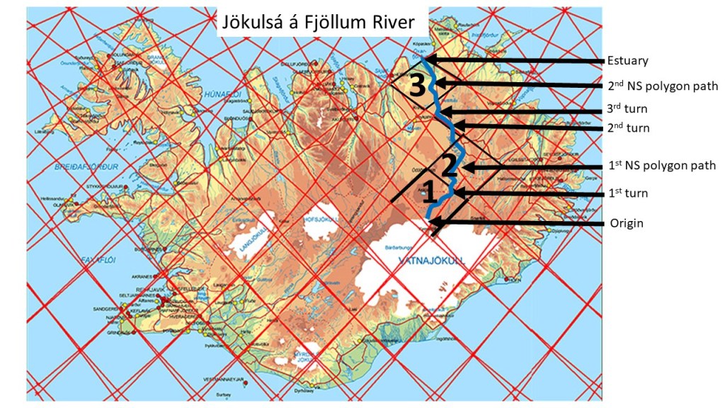
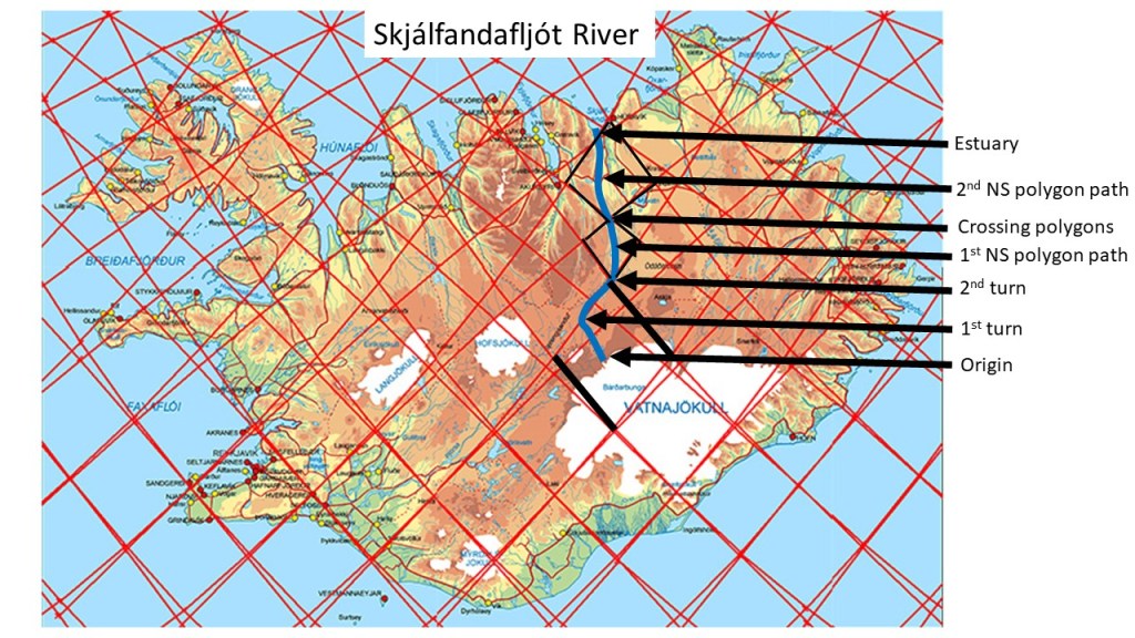
Geologists did search for a hotspot of Iceland, and came to the conclusion it should be found under Vatnajökull. This is a very active area, as two main volcanic zones meet there (East Volcanic Zone and North Volcanic Zone). The different trends of NE-SW fractures and NS fractures meet there, and the large volcanic sites of Grímsvörn, Bárðarbunga and Kverkfjöll are found there. Magma, specially from Bárðarbunga and Grímsvötn, has been found to flow far into the nearby polygons, causing vast eruptions. The hotspot is here seen as an active part of the interplay between convection rolls division lines, local rifting of the polygons and the effect of large scale tectonic drift of the tectonic plates of N-America and Eurasia.

Uncategorized

Convection – Vertical Circulation

Convection within the mantle is the driving force of volcanic eruptions, earthquakes and geothermal activity. Therefore, we should look at the function of convection. When molten material is heated, it expands at the heat source and rises up. This happens within the Earth, and luckily we can find out where the main ascending locations of magma are found. We just have to compare Earth’s layers with physics, and there we have it, as shown here:

The upwelling parts of Earth’s convection system.

The convection rolls extend from equator to 67.3°N and S. A polar system is found separately, but it has the same physical properties as the equatorial system. Understanding this is the prerequisite for analyzing Earth’s main geological processes.

Uncategorized

The Position of Ægir Ridge compared with Iceland and Norway

The Icelandic Plateau has a distinct elliptical shape, and thereby with a central point. This central point can be linked with continuations of Reykjanes Ridge and Kolbeinsey Ridge. Comparing that with the Ægir Ridge, another link is found, because there are exactly 15° between them along the relevant latitude (around 65.5°N). The Norwegian coast is found 15° along that latitude to the east.

Ægir Ridge https://en.wikipedia.org/wiki/Aegir_Ridge did shape most of the sea bottom between Iceland and Norway, until it was functionally replaced by the Kolbeinsey Ridge.

Iceland Plateau – Aegir Ridge – Norway

The fact that the exact center is at the eastern edge of Ægir Ridge can even tell a story for those exploring these features in the future. It shows that the ridge was shaped by the pulling effects between the North American Plate and the local small scale convection roll having opposing rotation, in the same way as the Kolbeinsey Ridge today, as well as the main volcanic zones of Iceland.

Uncategorized

The Path of Jökulsá á Fjöllum River in Iceland

A large river of North Iceland shows resemblance with the forces underneath. It finds its way directly to the north by swaying to the polygons east of the central axis of the North Volcanic Zone. The small polygons there are under pressure from the central polygons of the volcanic zone, thereby breaking up diagonally from north to south, providing tectonic lines for the river to follow.

Jökulsá á Fjöllum River.

Three polygons are marked on the map, namely those with inner tectonic structure for the river to flow afert. The first is still affected by the East Volcanic Zone, with tensional forces leading the river to the NE. At the boundary of the next polygon, the river is already east of the central axis, and the polygon must therefore be subject to some pressure and rotation, breaking it diagonally NS. The river flows to the 2nd turn where it starts following the border between two polygons. At the western corner of that polygon, it enters the realm of the third polygon, being the northernmost of the North Volcanic Zone series, it has a trend for providing NS tectonic features, leading the river accurately to the northernmost corner, where the estuary is found.

Uncategorized

The Path of Skjálfandafljót River in Iceland

The path of Skjálfandafljót can be traced according to the tectonics related to magma flow. First, the direction of each section follows the tensional matrix, or pressure induced on the primarily diamond-shaped polygons as shown here.

Skjálfandafljót River.

The origin follows an NW aligned path, until it reaches the border of the polygon, then it turns towards NE along the division line. At the northern end of the polygon, the river turns northwards, and crosses the northern corner of the other small polygon as well (1st NS polygon path), repeating the same story within the next polygon (2nd NS polygon path) until it reaches the estuary.

In this way, the relationship between tectonics and river flow can be explained, by referring to the effect of convection rolls below the tectonic plate. https://en.wikipedia.org/wiki/Skj%C3%A1lfandaflj%C3%B3t

The name, Skjálfandafljót, refers to the Skjálfandi Bay, literally meaning Trembling Bay due to frequent earthquakes in the area. The tectonical activity level probably contributes to the clear features of this particular river alignment.