Blog

Uncategorized

Hraunfossar – one of Iceland’s most outstanding waterfalls

Hraunfossar
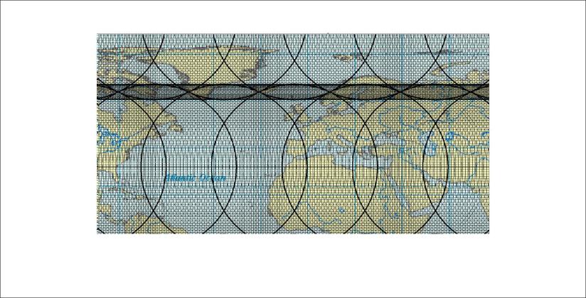
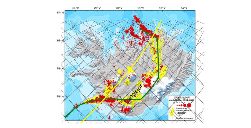
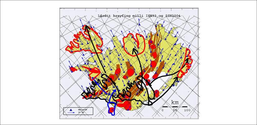
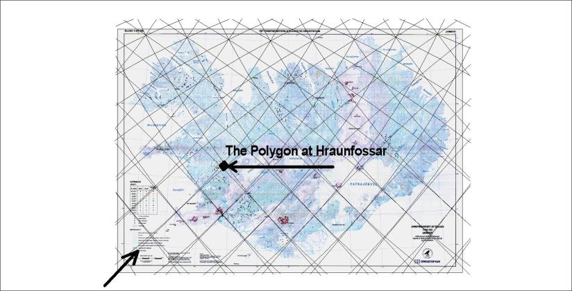
Hraunfossar – the waterfall of no river above it! The beauty and special settings of Hraunfossar can be partly explained. First we have to have in mind its position compared to the convection cell grid, as shown here on the base of a map from Náttúrufræðistofnun and Orkustofnun:

Hraunfossar og Barnafoss - 03

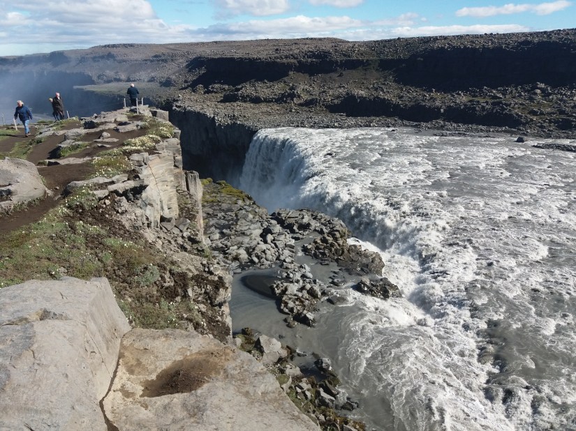
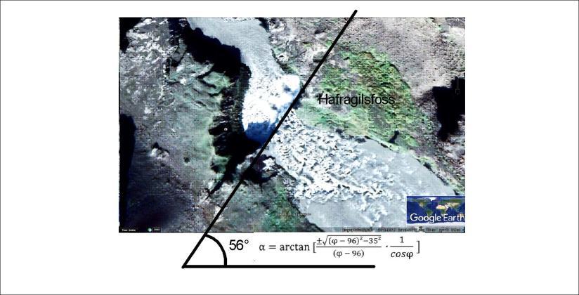
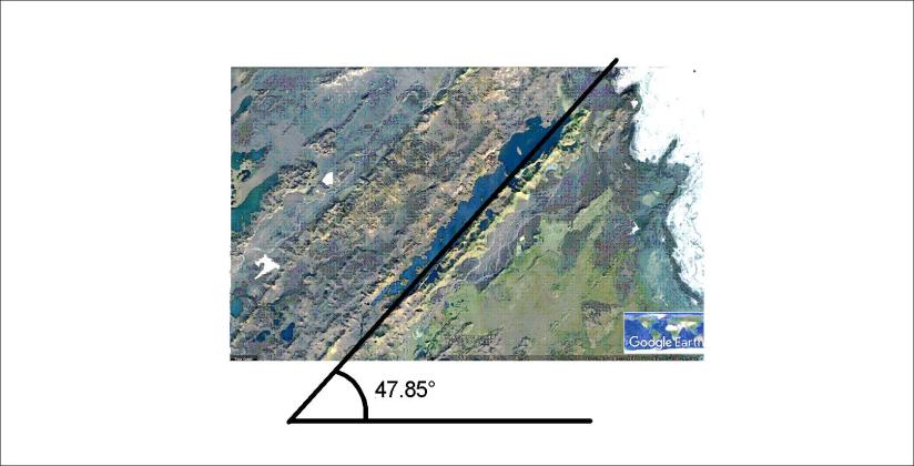
Let us zoom in on this polygon. According to the Convection Cell Model, the upwelling division line creating the Reykjanes Ridge is just at the side of the Hraunfossar waterfall. It can be seen on this Google map:

Hraunfossar og Barnafoss - 01

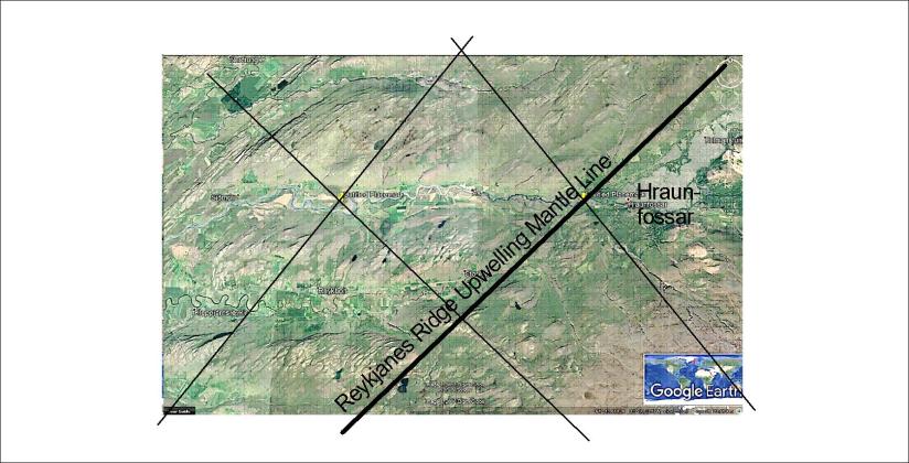
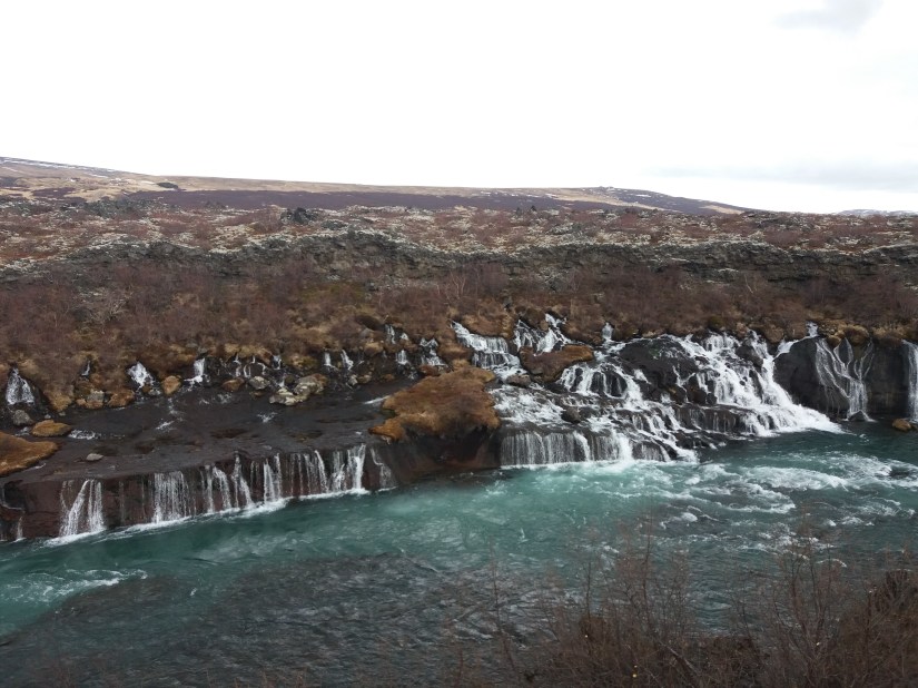
The small polygon, formed by near-crossing of four division lines between convection rolls, is subject to very clear EW-oriented tectonic settings due to the symmetry of the polygon. The river Hvítá flows accurately along the tectonic EW-axis, leading Hraunfossar to fall southwards into it. Let us now look even closer to realize what this waterfall is all about:

Hraunfossar og Barnafoss - 02

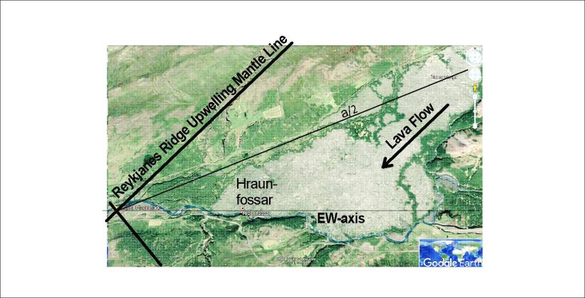
The lava, under which the water flows until it appears in the Hraunfossar waterfall, is considered to have flown in the 10th century. It is called Hallmundarhraun and has partly flown along a valley aligned exactly as the mantle convection line. The direction is E43.8°N. But that is not the ruling direction. A one step analysis of horizontal balance between EW-axis and the convection roll line shows the main outlines of the surrounding landscape. It is marked as a/2 and is aligned E21.9°N. The lava flow has been directed further along the E21.9°N topography alignment as it spread out along the valley of tectonic EW-axis, finally providing this excellent waterfall at the western most end of the lava.

geology

Dettifoss, Hafragilsfoss and Selfoss – the continuation of Hekla!

Dettifoss is the most powerful waterfall of Europe. The settings can be described as such: The river Jökulsá á Fjöllum does flow northwards, as the north volcanic zone of Iceland is aligned north-south. The edge of the waterfall is aligned N34°E. Why?

According to this analysis, Dettifoss is on the same line as the volcano Hekla! Here you see the waterfall and the relevant rift:

20180622_103922

From above it looks like this on Google map:

Dettifoss - 01

Dettifoss

The calculated value of direction of mantle convection rolls is the the same as that of the edge of the waterfall. As Dettifoss is on the latitude of 65.8°N, the calculated value becomes 56° angle from EW-axis.

Note that in the south of Iceland the direction of the volcanic zones is calculated with this formula. In the north of Iceland the symmetry of the magma currents of different layers does lead the zone directly northwards, but the direction of upper most NE-trending convection rolls still appear with the tectonics of the area.

The manifestations of how the magma currents shape the surface are endless!

Just to show the amazing possibilities this gives us to understand the environment better, just have a look at the other two waterfalls in the area, Hafragilsfoss and Selfoss.

Hafragilsfoss - 01

Hafragilsfoss is directed in exactly the same way as Dettifoss. It is easy to understand as the main upwelling division line of convection rolls passes through this area and is exactly oriented in the same direction.

But underneath there is another layer of convection rolls with opposite orientation. The next waterfall above Dettifoss is Selfoss, and the alignment of its edge can also be calculated!

Selfoss fyrir ofan Dettifoss- 01

It is all the same formula showing us all this. These calculations can of course be utilized for many purposes once this method becomes common knowledge.


Just to clarify this further, the position is shown on the map from Náttúrufræðistofnun and Orkustofnun.

Dettifoss - staðsetning

Being found along the continuation of the line of Hekla, with the correct alignment, it is a good example of how the convection cell system works.

Dettifoss - location - alignment compared with Hekla line

The ruling convection rolls division line extends from Hekla to the vicinity of the three waterfalls. Mathematics explain it all!


Uncategorized

The tectonic alignment of Yellowstone calculated in the same way as for volcanoes in Iceland

The Yellowstone area can be studied with a simple formula:

Yellowstone - 01

Many volcanic sites in Iceland can be calculated in the same way. For instance Hekla is aligned according the same formula as shown below.

Hekla - Trondheim - 01

In exactly the same way, the alignment of Hekla can be calculated, and its counterpart 30° farther to the east also! Without the knowledge of the forces underneath no one would see the resemblance.

All those places are aligned at an angle exactly between the direction of convection rolls and EW-axis. Yellowstone is in the middle of a diamond-shaped polygon, providing the basic framework for the surface tectonics.


Uncategorized

Langisjór – a very apparent feature following calculated alignment

It is a new approach to geology that the main tectonic directions of the globe can be calculated. No longer every detail has to be found out in the field, because the calculations can give guidance with accurate predictive data.

To show how this work, Langisjór in Iceland is a good example. The calculated grid of the surrounding areas of Iceland looks like this on the base of a GIS map where the degree is the base of length:

Langisjór - 01

The horizontal paths between convection rolls of different layars are drawn on the map.

We can then zoom in on this map to the scale of Iceland:

Langisjór - 03

The approximate location of the lake Langisjór is marked on the map.

Further zooming in gives us this picture on a google map:

Langisjór

The angle W47.85°N is a calculated value of the predicted alignment of the convection rolls causing the formation of volcanic zones in Iceland. Langisjór is a very good example because of its distinct volcanic features and the length scale of the adjacent volcanic formations.


Uncategorized

Tracing the drift of Vestfirðir, Tröllaskagi and Austfirðir

Having shown that the peninsula Vestfjarðakjálkinn is more and less identical to Tröllaskagi and Austfirðir combined, we can have a look at the preconditions for the resemblance. There are two main volcanic zones in southern Iceland which can produce two similar areas at the same time.

Vector derived tectonic drift - Vestfirðir - Tröllaskagi - Austfirðir 01

The Western Volcanic Zone of South Iceland is the origin of Vestfirðir, while within the Eastern Volcanic Zone of South Iceland the Tröllaskagi and East Fjords regions split apart and drifted to different directions. Note that Borgarfjörður is marked with blue and the drifting path with blue arrows as according to tracing the vectors it is originated where the Westman Islands are located today.

This can be derived by following the vectors of tectonic drift of the map shown here, resulting from the two measurements of ISN93 and ISN2004. The results were published by the National Land Survey of Iceland in 2007 (Landmælingar Íslands – Mælingasvið in 2007, report No. LM-2007-01).

The fact that all of this drift follows the vectors of tectonic drift as measured directly as carefully as possible with stations of reference in Europe and America. The symmetry of Hornstrandir and Austfirðir of 22° compared with NS-axis is also a manifestation. The angle of rotation can also be calculated as the difference of alignment of convection rolls.

The resemblance of coastlines is so accurate that further investigation is needed to understand why the similarities of the areas are so accurate.