Blog

Uncategorized

The Bridge Between Continents on Reykjanes Peninsula

The Bridge Between Continents on Reykjanes Peninsula is a popular tourist attraction. It is located at the western edge of the rift valley formed along the volcanic system of Reykjanes. Bridge Between Continents

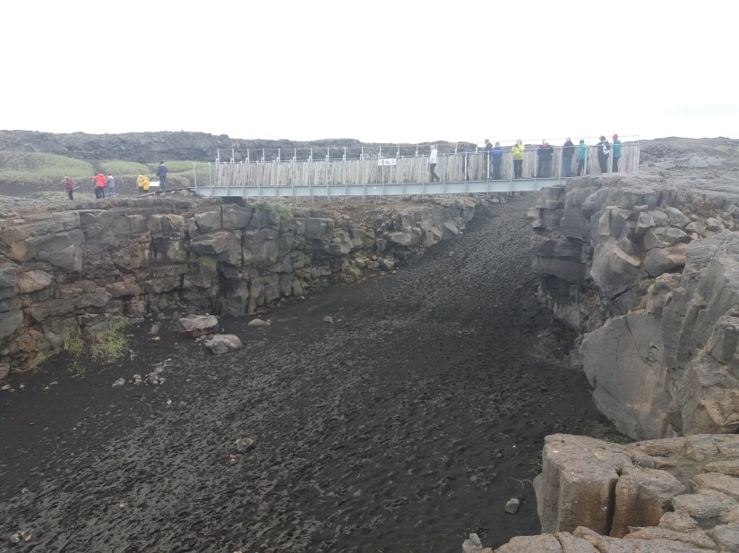
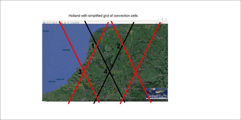
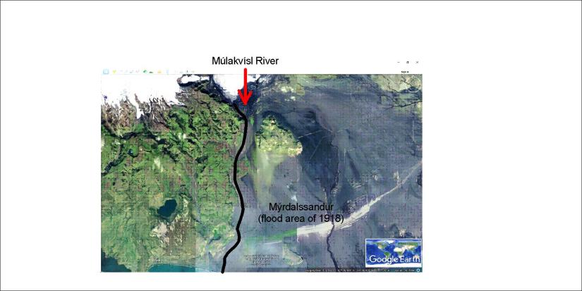
The rift follows the direction of the polar convection cells, as shown here on Google map:

Bridge Between Continents - Reykjanes

The outstanding part of the rift, with the bridge over it, is close to another less prominent feature. It is found to be due to horizontal tectonic force, as the angle is half of the other compared with EW-axis. The rift is supposed to have been deepened by the combined effect of these two tectonic alignments.

This is very similar to the settings of the Almannagjá rift of Thingvellir National Park, where the combination of tectonic alignments forms high walls at the side of the rift valley.


Uncategorized

How to find geothermal heat in Holland?

Can we find geothermal heat with the help of convection cell system? Yes, it is the very base of exploring the Earth’s surface. But how? Let us see the relevant part of the world convection cell grid drawn on a Google map:

Holland - convection lines

The country is mainly made up by two polygons, with EW-axis from points 1-2 and 3-4. The topographic consistency is mainly found on the line between points 1 and 4. Divergent force should be found close to the coast between 1 and 3.

Accordingly, searching for geothermal resources should in the beginning mainly be focused on line 1-4. (Actually Geothermal energy in the Netherlands has been partly modeled, showing precisely this trend, and can be seen on maps showing the tectonics of the Netherlands.) Then the pressure exerted on these two polygons should be estimated according to the precondition that it is originated from the relevant sides. Then the reason for the division found along 1-4 will be made clear. Thereby it can be found out weather EW-axis or NW-axis is the main factor for weakness within the tectonic plate. Then the main faults within the crusts can be found and mapped. The heat flow from the Earth can then be utilized effectively, as water can be heated by flowing along the deep faults.

This is not easy, but at least in this way we should know a bit more about what we are doing.

Red lines show upwelling, the upper more (120-250 km depth) aligned SW-NE, the lower more (250-410 km depth) aligned SE-NW. Black lines show downwelling.


Uncategorized

The Shape of the Icelandic Shelf

Having analyzed the axis from Central Iceland through Hekla and Eyjafjallajökull, it is notable that the shelf surrounding Iceland also follows the same trend.

Landgrunnid - sporaskja

The edge of the shelf closely follows an elliptical form, centered at the crossings of the continuation of the Reykjanes Ridge and the Hekla NS-axis. The parabola itself is centered around the relevant EW-axis.

Is there a reason for this we can explain? Yes, similar to the explanation about Snæfellsjökull and Snæfell.

Snæfellin 02

These mountains are equidistant from the same NS-axis as the shelf ellipse. The central point for the two volcanoes is on the division line of the lower mantle and thereby of the downwelling line of upper most mantle. The shelf ellipse central point is the next crossing nort of the main line, namely the extended line from the Reykjanes ridge, which is upwelling closest to the tectonic plate (120 km).

The ellipse is as close to being perfect as possible, having in mind all the complexities that should shape the ocean shelf around Iceland. Also, the fact that the highly elliptical Eyjafjallajökull is shaped around the same NS-axis is a curiosity.

Eyjafjallajökull - EW alignment

So much to speculate! But the base has been explained with the convection cell model.


Uncategorized

Skjálfandi Bay – rivers and whale watching

The Skjálfandi Bay is the most famous whale watching area in Iceland. Two rivers flow into the bay, providing nutrients for the whales. The tectonic framework is typical for the north of Iceland, a dominant NS-framework.

Skjalfandi

The framework is so obvious that there is no need exaggerating features by drawing the relevant lines on the Google map. The arrangement is clear. Note the feature aligned SE-NW in the upper corner to the right. This is the fault at Húsavík, an important part of the division of the tectonic plates of N-America and Eurasia.

The basic settings can be explained on a map base from the organization of Náttúrufræðistofnun:

Skjálfandi Bay and Tjörnes Fracture Zone

The area from the Google map is found within the blue polygon. The symmetry within the mantle is reflected by symmetry on the surface. The main Lower Mantle Division Line does cross the Tectonic Plate Division Line within the Skjálfandi Bay just outside the town of Húsavík. The division line is double or even triple, so another crossing is found in the Öxarfjörður Bay. Together these lines form the Tjörnes Fracture Zone.

the name Skjálfandi Bay can be translated as Tremble Bay or Earthquake Bay, because it is located within the fracture zone where earthquakes are quite common.

To be more precise, we can add the exact calculation for the Húsavík Fault:

Húsavík fault


Uncategorized

Múlakvísl – The World’s largest river in 1918?

When the volcano Katla erupted in 1918, a huge flood occurred in South Iceland. A smaller flood actually washed away the bridge of the river Múlakvísl in 2011 in the same area. It was expected that Katla would erupt after Eyjafjallajökull, because that sequence of events was also found in 1612 and 1823.

Occasionally, these floods become so big that the discharge exceeds the Amazon river. Therefore we say jokingly that the biggest river of the World is in Iceland.

The plain where the flood happens is called Mýrdalssandur, and the rivers Múlakvísl and Blautakvísl flow through the area. So for the eruption of Katla that started almost 100 years ago, the flood area is shown here on the Google map:

Múlakvísl

As for the tectonics of the area, a combination of SE-NW features of mantle alignment and NS topography leading the flow of rivers can be detected.