Uncategorized

Langisjór – a very apparent feature following calculated alignment

It is a new approach to geology that the main tectonic directions of the globe can be calculated. No longer every detail has to be found out in the field, because the calculations can give guidance with accurate predictive data.

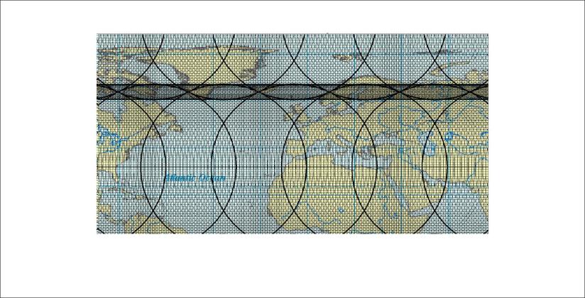
To show how this work, Langisjór in Iceland is a good example. The calculated grid of the surrounding areas of Iceland looks like this on the base of a GIS map where the degree is the base of length:
Langisjór - 01

The horizontal paths between convection rolls of different layars are drawn on the map.

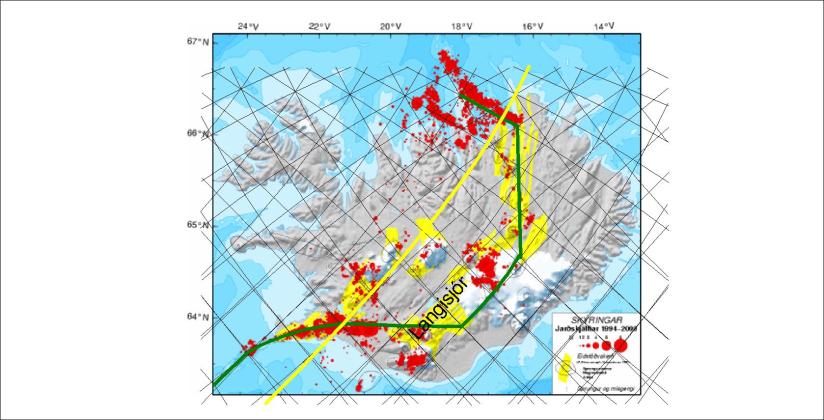
We can then zoom in on this map to the scale of Iceland:
Langisjór - 03

The approximate location of the lake Langisjór is marked on the map.

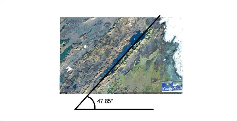
Further zooming in gives us this picture on a google map:
Langisjór

The angle W47.85°N is a calculated value of the predicted alignment of the convection rolls causing the formation of volcanic zones in Iceland. Langisjór is a very good example because of its distinct volcanic features and the length scale of the adjacent volcanic formations.


Uncategorized

Tracing the drift of Vestfirðir, Tröllaskagi and Austfirðir

Having shown that the peninsula Vestfjarðakjálkinn is more and less identical to Tröllaskagi and Austfirðir combined, we can have a look at the preconditions for the resemblance. There are two main volcanic zones in southern Iceland which can produce two similar areas at the same time.

Vector derived tectonic drift - Vestfirðir - Tröllaskagi - Austfirðir 01

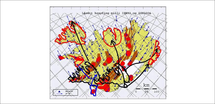
The Western Volcanic Zone of South Iceland is the origin of Vestfirðir, while within the Eastern Volcanic Zone of South Iceland the Tröllaskagi and East Fjords regions split apart and drifted to different directions. Note that Borgarfjörður is marked with blue and the drifting path with blue arrows as according to tracing the vectors it is originated where the Westman Islands are located today.

This can be derived by following the vectors of tectonic drift of the map shown here, resulting from the two measurements of ISN93 and ISN2004. The results were published by the National Land Survey of Iceland in 2007 (Landmælingar Íslands – Mælingasvið in 2007, report No. LM-2007-01).

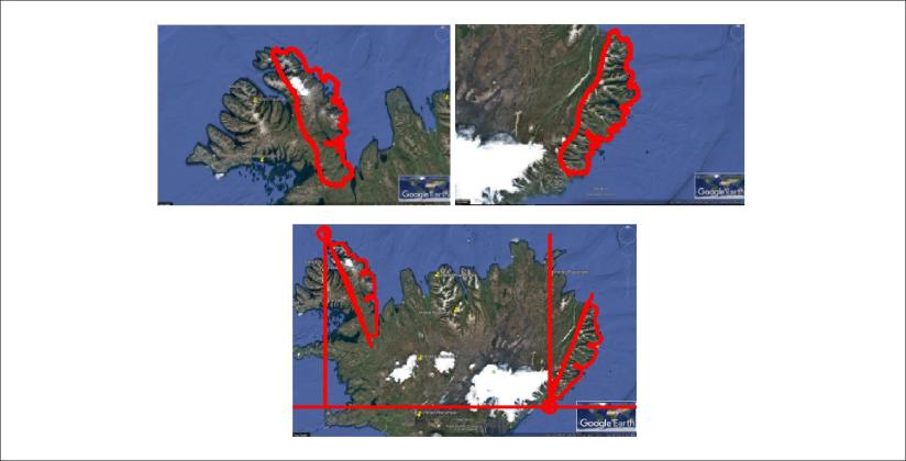
The fact that all of this drift follows the vectors of tectonic drift as measured directly as carefully as possible with stations of reference in Europe and America. The symmetry of Hornstrandir and Austfirðir of 22° compared with NS-axis is also a manifestation. The angle of rotation can also be calculated as the difference of alignment of convection rolls.

The resemblance of coastlines is so accurate that further investigation is needed to understand why the similarities of the areas are so accurate.


Uncategorized

Comparing Hornstrandir with Austfirðir

The eastern part of the NW-Peninsula and the Eastern Fjords of Iceland show remarkable resemblance. In addition, the angle between them is 44° of rotation, and the points of rotation are exactly 6° apart on 66.5°N and 64°N respectively as shown here:

Vestfirðir og Austfirðir - samanburður

How can different parts of Iceland be replicas of each other? The answer must be found in the coherent mathematics and information about tectonic drift.

The sections are so alike that the north end of them both have the same name: Kögur.

As shown in previous posts, the middle part of the Western Fjords Peninsula has a similar shape as the Tröllaskagi peninsula. When mathematical preconditions repeatedly manifest themselves, showing clear resemblance with real circumstances, it becomes a proof of relevance of the background theory.

Uncategorized

Comparing Tröllaskagi with Vestfirðir

It is amazing how the process of shaping the surface has resulted in similarities at different locations. Look at Tröllaskagi compared with the peninsula of Vestfirðir. Noticing that Ísafjarðardjúp has the alignment of equatorial mantle convection cells while Eyjafjörður has the direction of polar cells, the difference is about 22° of rotation for a match. In addition, the east coast of Skagafjörður and Arnarfjörður also match together. To trace the history of those two areas is a job for Superman.

Tröllaskagi compared with Vestfirðir

Actually, the fit itself is not the mane issue here. The main issue is that this resemblance could be systematically searched for, because the rotation points are exactly 3° apart, representing the distance between the division lines of two convection rolls along the parallel of 66°N. At those two locations, similar conditions of mantle convection cells should prevail.

Uncategorized

The twin fjords of Ísafjarðardjúp and Eyjafjörður

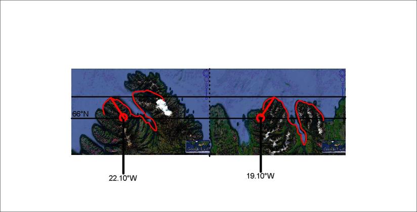
The two fjords Ísafjarðardjúp and Eyjafjörður are twin fjords. The shape is identical and their openings are on the same latitude.

It can be shown how the fjords have rotate around identical points 3° of longitude apart.

Ísafjarðardjúp og Eyjafjörður

The direction of the vectors from the point of rotation is the same as the calculated value of convection cells at 66°N, that is N33°E and N33°W. The rotation angle of Eyjafjörður compared to Ísafjarðardjúp is 22°, the same as the difference between equatorial and polar convection rolls alignment at the latitude.

A coincidence of this degree of mathematical coherence is virtually impossible.