Uncategorized

Hawaii and Iceland – mathematics show how they are connected

The two obvious volcanic spots of the globe, Hawaii and Iceland, are located on two of the main upwelling lines between convection rolls of the lower mantle.

Hawaii - Iceland

On these small drawings it is pointed out how polygons along the main division lines are regarded as the center of the hot spots. Actually, the hot spots have to be understood by referring to the relevant division line between convection rolls.

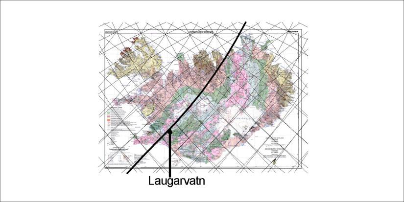
Here it is shown that the lines of Hawaii and Iceland are exactly 120° apart.

The reason for the arch-like shape of the convection rolls is that moving objects can not flow directly on the rotating Earth. A moving particle travels along a circular path, as can be seen on weather maps. Now, when the mathematics of the relevant path of mantle currents are known, geology will never be the same again.

Actually, it has been noticed that compared with Earth’s center, Hawaii and Iceland form 90° angle.

Uncategorized

The bread baked on the upwelling line at Laugarvatn

On the division line between the N-American plate and the Eurasian plate lies the lake Laugarvatn in Southern Iceland. Baking bread in the sand at the side of the lake is an old tradition.

20180730_162718

The bread has been in the boiling hot sand for 24 hours and is now fully baked.

The geothermal area is quite powerful. Look at the “border line” between the plates:

20180730_162958

Clearly, this natural bakery is no usual place.

Íslandskort - grind

The “border line” with Laugarvatn.


Uncategorized

The three sides of the Earth

We can make ourselves surprised, looking at the “land side” of the Earth and then at the “sea side” of it. So different! If you keep your head cool, you can say: “Yes, here I have the land mass of Eurasia, spanning 180° along the 64th parallel from the coast of Norway to the Bering Strait. On the other side the Pacific spans 150° from Indonesia to S-America along equator.” But we should not forget the two Americas, extending NS in the form of the letter “S” due to the effect of the Mid-Atlantic Ridge, and therefore resembling in a way the shape of the convection rolls within the mantle.

earth on 3 sides - land

earth on 3 sides - ocean

earth on 3 sides - americas

Measuring and reasoning can lead to conclusions. We should know at least a little bit about what we see 🙂


Uncategorized

The NVZ compared to EVZ and WVZ. Why the difference?

At around the 64° 45’N parallel a shift is found between the East Volcanic Zone and the North Volcanic Zone. The zones are connected at the Kverkfjöll area, but south of there the volcanic systems trend NE-SW, whereas north of there the NS alignment is obvious. Looking at the grid formed by convection division lines, this becomes more understandable. Along this parallel the grid is transformed from being composed of large and regular diamond shaped polygons south of the line, into the rather complex matrix of much smaller polygons. The overall match between volcanic zones and convection cell grid is obvious. The relevant lines are drawn on a map from Náttúrufræðistofnun:

Norður-gosbeltið 01