Uncategorized

Mid-Atlantic Ridge, East Pacific Rise and Central Indian Ridge – 90° apart

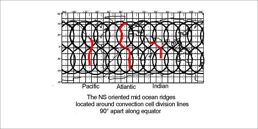
The three main mid-ocean ridges aligned NS are separated by about 90° along equator. The division line of upper mantle directly above lower mantle division is according to analysis a downwelling one, so ocean ridges do not tend to appear exactly there. A good example is the Reykjanes Ridge, following the path 1.5° to the west of the main division of lower mantle. Therefore, the three ridges are as close to being 90° apart along equator as the system allows.

The Mid-Atlantic Ridge 02

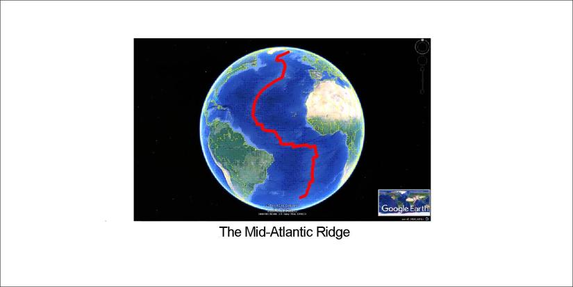
This is of course the theoretic distribution. The Mid-Atlantic Ridge is magnificent. But it is under the ocean like the other ridges.

The Mid-Atlantic Ridge

Uncategorized

The Geometry of China

China is very large and has a double nature, namely the Eastern and the Western parts. The division can be compared to the convection rolls, taking tectonic drift direction into account. The intersection between two circular zones divides China into two totally different parts. The border between China and India/Nepal is shaped exactly like the coastline of China. The amazing result is that most of Chinese territory is found within two circular effect zones with exactly the same radius, intersecting each other.

中国领土主要分两部分,东部和西部。这两个地区可以用两个圆圈来画出来,而东部圆圈的直径位于北纬32°。显出东部和西部两个圆圈直径是一样的。中国东部的北方和南方也可以这样分明,因为长江也接壤北纬32°。

Geometry of China

To fully understand this you must take all the Eurasian Plate into account.

Eurasia

Resulting in this simple drawing:

South China Fan

Please compare and find out more.


Uncategorized

The South China Fan

China, like other areas, has been gradually shaped by the tectonic drift of the continents. But at every moment in Earth’s history it is possible to compare the surface with the magma currents underneath. China has been formed in a particular way, and referring to the convection cell pattern it can be clarified further.

South China Fan

The perfectly circular shape of the SE coast of China is centered at the main division line of convection cells, exactly at 32°N where the mantle rolls are oriented NS.


Uncategorized

The framework of Iceland’s southern volcanoes

Katla and Eyjafjallajökull are the southernmost volcanoes, except for the Westman Islands. The framework extending from Hekla to Katla, along with Eyjafallajökull and Torfajökull exhibit the main tectonic fault directions. Usually we emphasize on the alignment of the Eastern Volcanic Zone in general (to the NE), but a simplified drawing of the polygons formed by the convection rolls look like that:

Southern Volcanoes 01

What is specially pointed out here is the connection of Katla with Torfajökull. The light coloured area shows two different alignments, originated from the NS-axis of the polygon. The NW trending faults are mirrored against the NE faults, having the same deviation from North, in opposite directions. The Torfajökull area is in a way confined south of the EW central polygon axis.

This interplay of EW-NE-NS-ES factors and even combinations of these have to be screened to understand the tectonics and distribution of volcanic sites. As previously mentioned, Hekla itself is askew with the system, but it can also be easily calculated like the rest of the southern features.

Uncategorized

Katla – the invisible volcano

Katla is a mystery, because no one has seen the volcano. Now we can detect it easily with modern technology through the ice sheet of Mýrdalsjökull, but somehow it remains obscure.

The division lines between convection rolls crossing below the mountain are marked on the map below. The black line is a downwelling line of the upper most layer, and the red line is upwelling line of the second layer.

Katla 01

Many of the most famous active areas in Iceland are found along these lines. That is in accordance with the activity of Katla – surprising everyone each time it erupts.