Uncategorized

The Aegir Ridge Compared with Geological Features of Iceland

The Aegir Ridge is a huge geological feature, in between Iceland and Norway. The Wikipedia descirption of it is here: https://en.wikipedia.org/wiki/Aegir_Ridge. It was responsible for the opening of the Atlantic Ocean at the relevant latitudes, but is now extinct and drifts along with the Eurasian Tectonic Plate.

All the same, the Aegir Ridge shows resemblence with the tectonic arrangement of Iceland. Moreover, it is all in accordance with the convection rolls system, as shown here:

Aegir Ridge with Convection Rolls Division Lines.

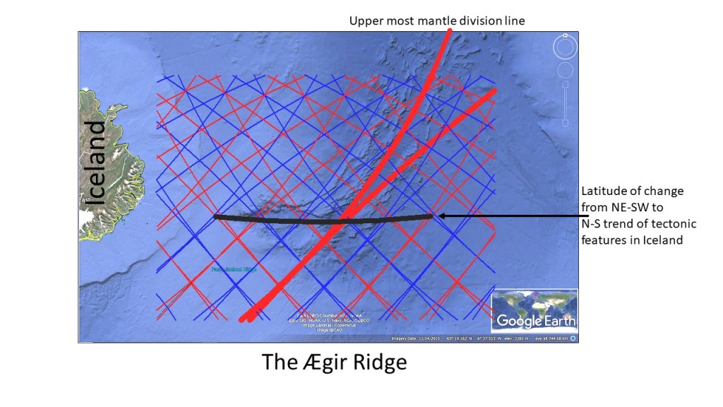
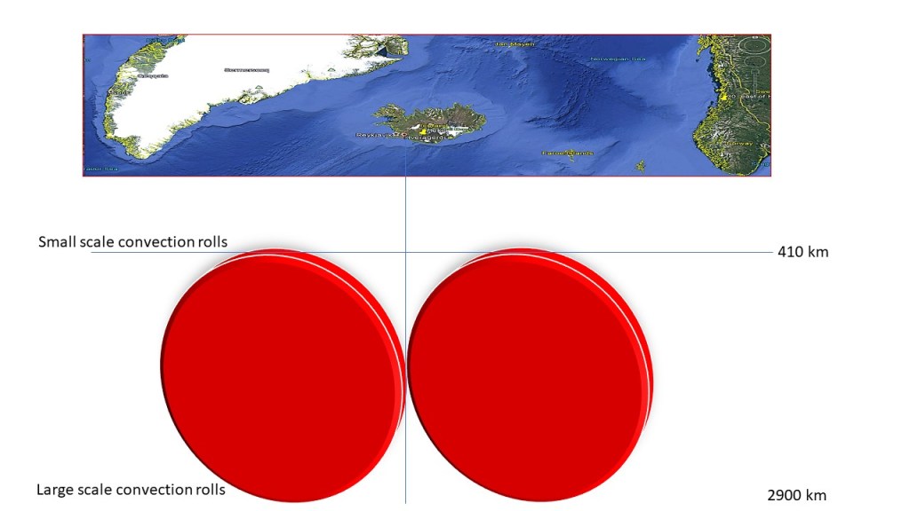
The Aegir Ridge, as seen on this Google Map, is aligned E-W at the latitude of 64°50′, where the main tectonic features of Iceland make a turn from NE-SW (south of the line) to N-S (north of the line). The northern part of Aegir Ridge follows the same alignment as the upper most convection rolls of 120 km depth. The central line is the tenth convection roll division line counted from the Reykjanes Ridge convection rolls division line. That is half the span of the large convecton roll extending from Iceland to Norway, as each large scale roll spans 30° from east to west. Small scale rolls span 1.5° from east to west.

Uncategorized

Sections of Large Scale Convection Rolls below the Atlantic Ocean

The convection rolls under the tectonic plates can be represented with short sections. The most obvious example is found under the Atlantic Ocean.

Simplified Drawing of Short Sections of Convection Rolls.

These large scale convection rolls span 30` along each latitude, as shown below.

Outer Limits of Convection Rolls Sections Marked with Red.

These drawings can then be used for a first step learning to be able to understand the Convection Rolls System. The convection rolls shaping the Atlantic Ocean were in fact first noticed a long time ago, but attention was mainly directed towards surface features. Alfred Wegener noticed that the continents fit together, and was clear-headed enough to see that it could be no coincidence. Then he systematically studied each side of the Atlantic, and other parts of the world, to find the global picture of tectonic drift. In the same way, we can make use of the clarity of structure of the Atlantic Ocean to understand the forces responsible for tectonic drift, volcanic activity and formation of geothermal areas.

Uncategorized

An Example of Epicenters Alignment of Tjörnes Fracture Zone

The Tjörnes Fracture Zone combines the North Volcanic Zone with the Kolbeinsey Ridge. The alignment of epicenters follows the mathematical model of convection rolls closely. Today, the ‘Met Office’ map looked like that:

Epicenters of TFZ 17-8-2020

Comparing with the convection rolls model shows how the SE-NW alignment follows the division line, whereas the N-S aligment does trace the central axis of the polygon marking the very beginning of Kolbeinsey Ridge.

Seismic activity of TFZ 17-8-2020

Besides that, Grímsey is pointed out. Grímsey Island is the northern most inhabited part of Iceland. It is found close to a ‘hub’ of division lines of different layers, leading to an anomaly of volcanic and geothermal activity within the surrounding area.

Uncategorized

About the Distribution of High Temperature Areas in Iceland

The high temperature areas in Iceland can be divided into four, rather distinct, areas. Here they are marked with SW = southwest (Reykjanes Peninsula), S = South Iceland, C = Central areas, and N = North Iceland.

The high temperature areas

The basic map is from Orkustofnun https://orkustofnun.is/gogn/Skyrslur/OS-2003/OS-2003-062.pdf

SW: Reykjanes consists mainly of one polygon, with Svartsengi on a division line, and also Hengill, but the other three areas of Reykjanes, Krýsuvík and Brennisteinsfjöll are found on the tectonic division line between N-America and Eurasia.

S: These areas are found to the SW of the main rift zone of Iceland, East Volcanic Zone.

C: This is the largest area. The hight temperature areas are found at the main crossings found between the division lines, therefore forming a rather regular pattern. This consistency between division lines and high temperature areas is one of the proofs of the existence of the division lines surrounding the polygons.

N: These areas form a line oriented directly N-S. Two of them are strictly originated from the tectonic division line, besides being centrally located within the relevant polygon, namely Askja and Fremrinámar. The others are found in context with the Mývatn hub of small polygons. Öxarfjörður is here classified as high temperature area, being exactly at crossings of convection rolls division lines and the tectonic N-S division line.