
A geometrical relationship between oceanic spreading ridges, subduction zones, and the South Pole
1. Introduction
The Antarctic Plate occupies a unique position in Earth’s global tectonic system. Unlike most major lithospheric plates, it surrounds a geographical pole and is bounded predominantly by oceanic spreading ridges. Its margins include several important triple junctions, major transform faults, and a complex region of subduction and plate interaction south of South America.
The proposed Antarctic ellipse provides a mathematical framework for examining this arrangement. The model is based on six reference locations around the Antarctic Plate, selected for their geological significance and their relationships to the South Pole.
Two of these locations establish the direction and dimensions of the ellipse’s major axis. A third lies close to one endpoint of the minor axis. The fourth is a mathematical reference point situated between two distinct geological features. The remaining two locations provide additional opportunities to test the proposed geometry against independently identified plate boundaries.
2. Definition of the Antarctic ellipse
The ellipse is defined in a south-polar azimuthal equidistant projection, with the geographical South Pole at its centre.
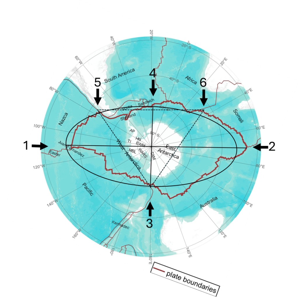
Its principal dimensions are:
| Parameter | Value |
|---|---|
| Centre | South Pole, 90°S |
| Semimajor axis | 60° |
| Semiminor axis | 30° |
| Full major axis | 120° |
| Full minor axis | 60° |
| Major-to-minor axis ratio | 2:1 |
The four mathematically defined endpoints are:
| Axis endpoint | Latitude | Longitude |
|---|---|---|
| Major axis, Pacific sector | 30°S | 109°37.5′W |
| Major axis, Indian Ocean sector | 30°S | 70°22.5′E |
| Minor axis, Ross Sea sector | 60°S | 160°22.5′E |
| Minor axis, Weddell Sea sector | 60°S | 19°37.5′W |
The angular separation between adjacent axis directions is exactly 90°. The ellipse is therefore symmetrical around the South Pole.
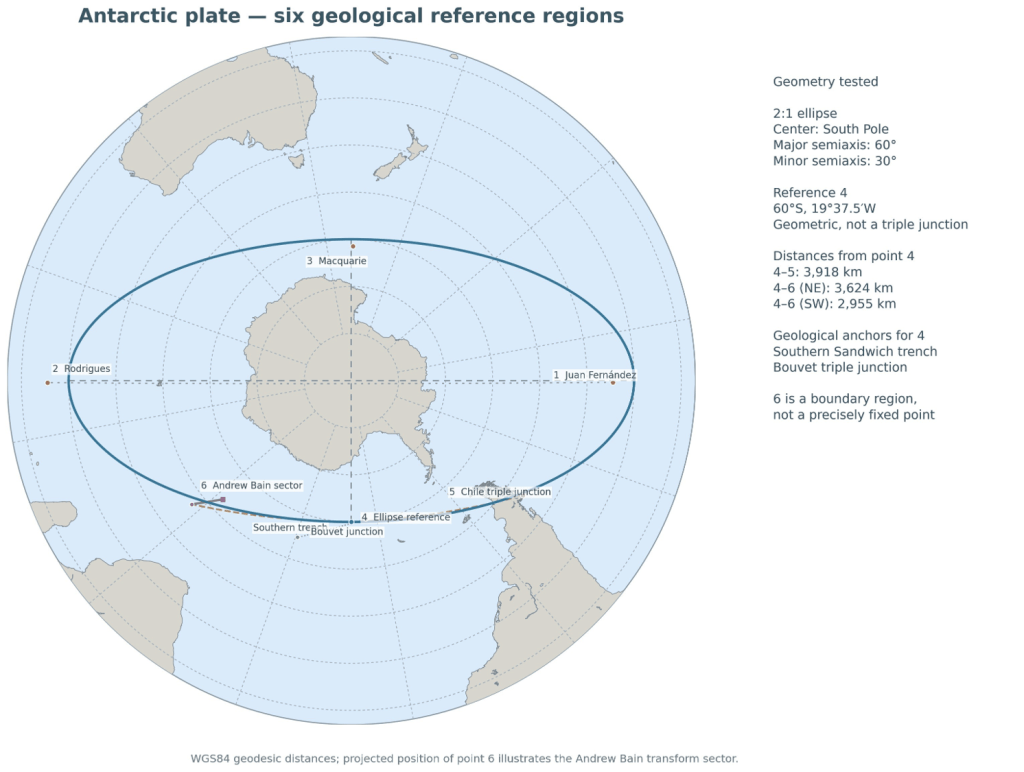
The 2:1 ratio is a property of this mathematical construction. The dimensions follow from averaging the polar distances of the two major oceanic reference points.
3. Points 1 and 2: The major-axis alignment
Point 1 — Juan Fernández, East Pacific Rise
The first reference point is located near 34°30′S, 109°15′W, in the southern Juan Fernández microplate region.This area forms part of the tectonically complicated boundary system involving the Pacific, Nazca, and Antarctic plates. The Juan Fernández microplate modifies the otherwise relatively simple intersection between the East Pacific Rise and the Chile Transform system.
The selected coordinates correspond to the intersection of the eastern Juan Fernández spreading ridge with the Chile Transform, rather than necessarily representing a single stable three-major-plate junction.
Point 2 — Rodrigues Triple Junction, Indian Ocean
The second point lies near 25°30′S, 70°E. Here, the Central Indian Ridge, Southwest Indian Ridge, and Southeast Indian Ridge meet. The Rodrigues Triple Junction is a well-established example of a ridge–ridge–ridge triple junction involving the Antarctic, African, and Indian plate systems.
The geographical relationship between Points 1 and 2 is particularly notable. Their longitudes differ by approximately 179.25°, placing them almost directly opposite one another relative to the South Pole. The great-circle route connecting them passes approximately 72 km from the pole.
Their angular distances from the South Pole are:
- Point 1: 55.5°.
- Point 2: 64.5°.
The mean distance is 60°.
This gives the proposed major axis a total length of 120° in the polar projection. The observed junctions are not themselves the exact endpoints of the symmetrical ellipse. They lie on opposite sides of those theoretical endpoints, each differing by approximately 4.5° in polar distance.
Nevertheless, their nearly opposite longitudinal directions provide a clear geometrical basis for defining the major-axis orientation.
4. Point 3: The Macquarie Triple Junction
Approximate position: 61°30′S, 161°E.
The third reference point is located south of New Zealand, where the Antarctic, Australian, and Pacific plate-boundary systems intersect. This region is associated with the Southeast Indian Ridge, the Macquarie Ridge, and the Hjort Trench system. The geological configuration also involves the more recently recognised Macquarie microplate.
In the proposed ellipse, the corresponding minor-axis endpoint is located at:
60°S, 160°22.5′E.
The geographical separation between the reference point and the theoretical endpoint is approximately 171 km. This represents a relatively small difference on the scale of the Antarctic Plate. Point 3 therefore provides an important reference for the orientation of the minor axis, independently of the Pacific and Indian Ocean junctions used to establish the major axis.
5. Point 4: A mathematical endpoint between two geological features
Point 4 requires a different definition from the other locations.
It is not an independently identified geological triple junction.
It is the theoretical Atlantic-sector endpoint of the minor axis:
60°S, 19°37.5′W.
Two important geological features lie on opposite sides of this longitude.
The South Sandwich subduction system
West of Point 4 lies the South Sandwich Trench, where oceanic lithosphere of the South American Plate is subducted beneath the South Sandwich Plate. The southern part of the trench terminates near the South Sandwich Fracture Zone, which forms part of the boundary system involving the Antarctic Plate.
Factorian Deep, located near 60.479°S, 25.542°W, provides a measured geographical reference in the southern trench. Its distance from Point 4 is approximately 332 km. The South Sandwich Fracture Zone itself extends approximately between 24°W and 17.5°W, near 60.5–60.75°S. Its gazetteer reference position lies within about 93 km of the theoretical endpoint.
Thus, the mathematical point is close to an actual tectonic transition zone, although it should not be identified directly with a particular triple junction.
The Bouvet Triple Junction
East of Point 4 lies the Bouvet Triple Junction, near:
54°50′S, 0°40′W.
Here, the South American, African, and Antarctic plates meet at the intersection of the southern Mid-Atlantic Ridge, the American–Antarctic Ridge, and the Southwest Indian Ridge.
Its geographical distance from Point 4 is approximately 1,270 km. Consequently, Point 4 lies between the South Sandwich system to the west and the Bouvet Triple Junction to the east in terms of longitude. It is not equidistant from them, nor is it their geographical midpoint. Its significance is that the independently defined minor axis passes through this part of the southern Atlantic plate-boundary system.
6. Point 5: The Chile Triple Junction
Approximate position: 46°12′S, 75°48′W.
The Chile Triple Junction marks the intersection of the Nazca, Antarctic, and South American plates near the Taitao Peninsula in southern Chile. At this location, the Chile Ridge, a spreading boundary between the Nazca and Antarctic plates, reaches the Chile Trench and is being subducted beneath South America.
North of the junction, the Nazca Plate descends beneath South America. South of it, the Antarctic Plate occupies the corresponding oceanic plate-boundary sector.
Point 5 can therefore be regarded as the northern termination of the Antarctic–South American convergent boundary in this particular sector, rather than the northernmost point of the Antarctic Plate as a whole. Its geographical position provides an additional test of the proposed ellipse.
At longitude 75.8°W, the theoretical 2:1 ellipse reaches approximately 46.81°S. The observed triple junction lies near 46.2°S, corresponding to a radial difference of approximately 66 km. The proximity is notable because Point 5 was not used to determine either the major-axis or minor-axis lengths.
7. Point 6: The African deformation system and the Southwest Indian Ridge
Point 6 concerns a particularly complicated and often less prominently discussed part of the global plate-boundary system. The African continent is commonly represented as one large plate, but present-day plate-kinematic models distinguish between the Nubian and Somalian plates, separated by the East African Rift System.
Farther south, the boundary becomes diffuse and difficult to identify from ordinary geological maps. Nevertheless, plate-motion studies indicate that deformation associated with the separation of Nubia and Somalia extends toward the Southwest Indian Ridge, where the African plate system meets Antarctica. Horner-Johnson and colleagues (2005) placed the intersection of a hypothetical narrow Nubia–Somalia boundary with the ridge between approximately 26.3°E and 32.2°E.
Subsequent studies identified the Lwandle Plate between the Nubian and Somalian plates in parts of the southwestern Indian Ocean. Consequently, this region is better understood as a complex plate-boundary system than as a single, permanently fixed triple junction.
The Andrew Bain Transform Fault Complex
One of the most prominent structures in this region is the Andrew Bain Transform Fault Complex. It offsets the Southwest Indian Ridge by several hundred kilometres and extends between two important ridge–transform intersections:
| Reference location | Latitude | Longitude |
|---|---|---|
| Southwestern intersection | 52°50′S | 27°40′E |
| Northeastern intersection | 47°10′S | 32°35′E |
These are real geological reference points, but neither necessarily represents the precise meeting point of the Nubian, Somalian, and Antarctic plate systems. The proposed 2:1 ellipse intersects a straight-line approximation between these two locations near 50.04°S, 30.09°E. This position is a calculated intersection, not a newly identified geological triple junction. Nevertheless, it lies within the geographically relevant Andrew Bain region and provides a useful target for further examination of plate-boundary data.
8. The relationship between Points 4, 5, and 6
One of the potentially significant geometrical observations concerns the distances and directions between Points 4, 5, and 6.
Taking Point 4 as the theoretical minor-axis endpoint at 60°S, 19°37.5′W gives the following approximate distances.
| Relationship | Distance |
|---|---|
| Point 4 to Chile Triple Junction (5) | 3,918 km |
| Point 4 to northeastern Andrew Bain intersection | 3,624 km |
| Point 4 to southwestern Andrew Bain intersection | 2,955 km |
| Point 4 to calculated ellipse–Andrew Bain intersection | 3,277 km |
The distance from Point 4 to the northeastern Andrew Bain reference point differs from the distance to Point 5 by approximately 294 km, or 7.5%.
Their initial geographical bearings from Point 4 are also strikingly close to opposite directions:
- Toward Point 5: approximately 267.2°.
- Toward the northeastern Andrew Bain reference: approximately 90.7°.
The angular difference is approximately 176.6°, close to 180°.
Thus, Points 5 and 6 lie in nearly opposite directions from the theoretical Point 4.
However, because Point 6 represents a broad and geologically complicated boundary region, the apparent symmetry depends on which part of that region is selected. The distances are not precisely equal, and a geological definition of Point 6 must precede any claim of exact geometrical correspondence. This makes the relationship a useful hypothesis for further testing rather than a demonstrated geometrical law.
9. The Icelandic shelf ellipse and its relationship to Antarctica
A separate but potentially related elliptical structure has been proposed for the Icelandic shelf.
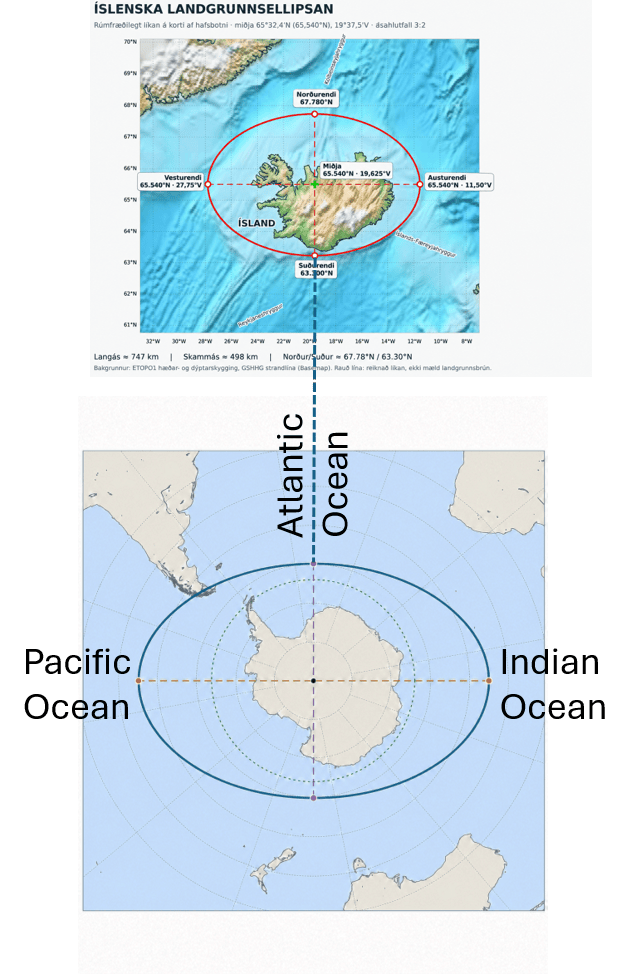
The Icelandic shelf is an elevated region of the North Atlantic seafloor, associated with the Greenland–Iceland–Faroe Ridge system and the interaction between the Mid-Atlantic Ridge and Icelandic mantle processes.
In the proposed geometrical model, the shelf is represented by an ellipse with the following dimensions:
| Parameter | Icelandic shelf ellipse |
|---|---|
| Centre | 65.54°N, 19°37.5′W |
| Major-axis orientation | East–west |
| Minor-axis orientation | North–south |
| Major-axis length | Approximately 747 km |
| Minor-axis length | Approximately 498 km |
| Axis ratio | 3:2 |
The minor axis extends along the meridian 19°37.5′W.
This is particularly interesting because the Atlantic-sector minor-axis endpoint of the Antarctic ellipse is also defined at 19°37.5′W. The two axes consequently lie in the same great-circle plane, passing through both geographical poles.
This does not imply that the Icelandic and Antarctic ellipses have identical dimensions or necessarily share a physical origin. Indeed, the newly proposed Antarctic ellipse has a 2:1 ratio, whereas the Icelandic shelf ellipse has a proposed ratio of 3:2. Their relationship is primarily one of geographical alignment, within a wider investigation of geometrical patterns in tectonic systems.
The Icelandic shelf model also associates the minor-axis direction with the alignment of volcanic centres including Eyjafjallajökull, Tindfjöll, and Hekla, as discussed in The Elliptical Form of the Icelandic Shelf and Its Geological Significance (2025).
You can read about it here: .https://magicmagma.com/2026/06/01/eyjafjallajokull-and-katla-an-east-west-volcanic-axis-in-south-iceland/
The Eyjafjallajökull Ellipse and Its Geometrical Relationship to Iceland and Antarctica
An additional geometrical relationship emerges from the elliptical structure surrounding Eyjafjallajökull in southern Iceland. The proposed ellipse encompasses the volcanic edifice and its surrounding foothills, with an east–west major axis of approximately 34 km and a north–south minor axis of 17 km, giving a 2:1 axis ratio. Its centre is located at 63°37.5′N, 19°37.5′W, directly along the minor axis of the larger Icelandic shelf ellipse, whose centre lies at approximately 65.54°N on the same meridian.
These relationships are particularly interesting because the minor axes of the two Icelandic ellipses follow the same meridian, 19°37.5′W, which also defines one of the minor-axis directions of the Antarctic ellipse. Thus, the proposed geometrical framework connects a local volcanic structure, the Icelandic shelf, and the Antarctic Plate through a shared geographical orientation, while displaying different axis ratios at different scales. Whether these correspondences reflect an underlying tectonic or mantle-dynamic relationship remains a subject for further investigation.
10. Relationship to mantle convection and the three tectonic rings
The proposed Antarctic geometry can also be examined in the context of the Convection Rolls Model.
In that model, the lower mantle is represented by a system of circular convection components spaced at 15° longitudinal intervals. Three further elliptical systems are proposed around the Pacific, Indian, and Atlantic Oceans, with centres separated by 120° of longitude. The Antarctic Plate occupies a central position relative to their southern sectors. Its major-axis directions point toward the Pacific and Indian Ocean ridge systems, while its minor-axis directions connect the Ross Sea and southern Atlantic sectors.
The Antarctic ellipse, the three tectonic rings, and the Icelandic shelf ellipse therefore provide different scales of geometrical comparison within the proposed convection-roll framework. Whether the alignments arise from a common mantle-dynamic organisation remains an open question. The correspondence of selected locations alone cannot demonstrate that mantle convection takes the form proposed by the model.
11. Conclusions
The six-point analysis produces several testable results. The first two reference points, near the Juan Fernández microplate and the Rodrigues Triple Junction, establish an almost straight major-axis direction passing close to the South Pole. Averaging their polar distances gives a major-axis semilength of 60°.
Point 3, at the southern Macquarie plate-boundary junction, lies approximately 171 km from a theoretical minor-axis endpoint at 60°S, 160°22.5′E.
Point 4 is a mathematical endpoint, rather than a geological triple junction. It lies between the South Sandwich subduction system and the Bouvet Triple Junction, and close to the South Sandwich Fracture Zone.
Point 5, the Chile Triple Junction, lies approximately 66 km radially outside the proposed elliptical boundary.
Point 6 involves the diffuse boundary system extending from eastern and southern Africa toward the Southwest Indian Ridge. The Andrew Bain Transform Fault Complex provides important geological reference locations, and the proposed ellipse crosses this region.
The approximate opposition of Points 5 and 6 relative to Point 4 is a particularly interesting additional geometrical feature, although the location and width of the African boundary system introduce considerable uncertainty.
Finally, the Icelandic shelf ellipse introduces a second geographical scale. Its proposed minor axis shares the meridian of the Antarctic ellipse’s Atlantic-sector minor-axis endpoint.
Taken together, these relationships suggest that elliptical geometry may offer a useful framework for comparing the positions of major plate-boundary junctions, spreading ridges, and selected volcanic regions.
Selected references
Anderson-Fontana and colleagues (1987). Tectonics of the Nazca–Antarctic plate boundary. Earth and Planetary Science Letters. DOI
Falconer (1972). The Indian–Antarctic–Pacific triple junction. Earth and Planetary Science Letters. DOI
Horner-Johnson et al. (2005). The angular velocity of Nubia relative to Somalia and the location of the Nubia–Somalia–Antarctica triple junction. Geophysical Journal International. DOI
Horner-Johnson and colleagues (2007). Plate kinematic evidence for the existence of a distinct plate between the Nubian and Somalian plates along the Southwest Indian Ridge. Journal of Geophysical Research. DOI
Phillips and Tapscott (1976). The Bouvet Triple Junction. Journal of Geophysical Research. DOI
Thorbjarnarson (2025). The Elliptical Form of the Icelandic Shelf and Its Geological Significance. MagicMagma


