
Antarctica displays several different levels of large-scale geometric organization. These should not be confused with one another, because they are based on different observations and have different degrees of certainty.
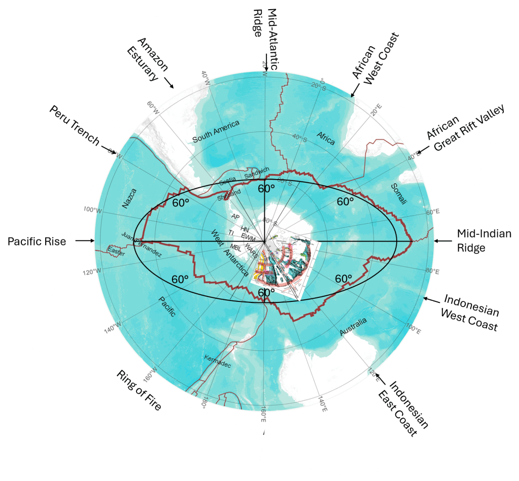
Article link (with inserted map): https://www.nature.com/articles/s41561-026-01991-6
Map base: https://www.sciencedirect.com/science/article/pii/S1674984722000775
At the most familiar level, the continental part of Antarctica is divided into East Antarctica and West Antarctica. East Antarctica consists largely of old Precambrian continental crust, whereas West Antarctica is much more tectonically fragmented and includes the West Antarctic Rift System. The Transantarctic Mountains form the most conspicuous boundary between these two major regions. This fundamental division has been recognized for many decades and is firmly established by geological and geophysical observations.
At another scale, when the entire Antarctic tectonic plate is considered, including its oceanic lithosphere, a broader geometric pattern becomes visible. In the Mantle Convection Roll model, the outline of the Antarctic Plate can be approximated by an elliptical form centred approximately on the South Pole. A major and a minor axis then divide this ellipse into four main sectors. The axes used in this comparison are approximately 70°22.5′E–109°37.5′W and 160°22.5′E–19°37.5′W, respectively.
A third and much more tentative possibility has now become particularly interesting. New geophysical results from East Antarctica may indicate that another level of organization exists: a division into sectors of approximately 60° around the South Pole.
This is not established. It is a geometric possibility suggested by comparison between the new observations and the larger Antarctic pattern. But the measurements are remarkable enough to make such a comparison worthwhile.
The East Antarctic Fan-Shaped Basin Province
In 2026, Armadillo et al. described what they call the East Antarctic Fan-Shaped Basin Province (EAFBP). Using improved subglacial topographic data together with seismic, gravity and magnetic information, they identified 30 major basins beneath a very large part of the East Antarctic Ice Sheet. Many are approximately V-shaped and elongated radially towards the interior of Antarctica. Collectively, the basins form a huge fan-like structure extending roughly from Prydz Bay at 70°E to the Transantarctic Mountains at about 160°E.
This is not merely a visual impression from a map. The authors fitted 60 great circles to the longitudinal edges of the basins and calculated more than one thousand intersections. From these they obtained a best-fitting Euler pole at 86.4°S, 129.9°E.
This point is only about 3.6° of latitude, or roughly 400 km, from the geographic South Pole. The fan also has a well-defined axis close to the 130°E meridian, passing through the Belgica Subglacial Highlands. The authors call this the Belgica Bisector. The observed basin system is divided by this line into a sinistral sector to the west and a dextral sector to the east.
There is additional evidence that the geometry penetrates deeply into the lithosphere. Models based on seismic and gravity information show reduced crustal thickness beneath the major basins, while seismic tomography identifies low-velocity anomalies beneath the Wilkes and Aurora basins at upper-mantle depths. Thus, the fan-shaped pattern is not simply a feature produced by glacial erosion at the surface.
Perhaps even more strikingly, the authors identify two approximately circular transverse shear belts. Independent fitting gives Euler poles at 84.2°S, 130.8°E and 83.1°S, 129.5°E.
Thus three separately calculated geometric poles cluster within a relatively small region close to the South Pole and close to the same meridian: 86.4°S, 129.9°E, 84.2°S, 130.8°E, and 83.1°S, 129.5°E.
This repeated convergence towards the polar region is an important observational result, regardless of how its cause is ultimately interpreted.
Rotational extension — observation or explanation?
Armadillo et al. interpret the structure as the product of distributed intraplate rotational extension. In their model, the crust opened rather like a handheld fan around an Euler pole close to the South Pole. The Aurora and Wilkes basins developed on opposite sides of the Belgica Bisector, and displacement increased away from the pivot. The geometry certainly supports a rotational description.
However, there is an important distinction between describing the resulting deformation and identifying the deeper force that produced it. In the interpretation considered here, rotational extension may be a secondary kinematic effect rather than the primary geodynamic cause.
The proximity of the calculated Euler pole to the geographic South Pole is therefore particularly important. It does not, by itself, prove that Earth’s rotation caused the deformation. An Euler pole is fundamentally a geometric description of rotational motion, and many plate motions have Euler poles unrelated to geographic poles. Nevertheless, when a continental-scale system of radially arranged structures produces several independently calculated deformation poles close to the geographic pole, the relationship deserves attention—particularly in a model in which mantle convection itself is organized by planetary rotation.
The role of Earth’s rotation
Earth’s rotation alone cannot provide a satisfactory direct mechanical explanation for opening major crustal basins hundreds or thousands of kilometres long. The stresses required must ultimately be transmitted through the lithosphere from processes capable of doing substantial tectonic work.
In the Mantle Convection Roll model, the connection is indirect but mechanical:
Earth’s rotation → organization of mantle convection → systematic mantle-flow stresses → deformation of the lithosphere.
The rotation of the Earth organizes the convection system. The mantle flow then supplies the forces acting on the overlying lithosphere. From this perspective, a tectonic pattern centred close to the geographic pole would not result simply from a vague “rotational force”. It would reflect the geometry of a mantle-flow system whose organization is itself controlled by rotation.
The new Antarctic measurements provide evidence for the geometry of deformation. They do not establish the Mantle Convection Roll interpretation. But they provide a new and unusually clear geometric pattern against which that model can be tested.
Could Antarctica contain six alternating 60° sectors?
The mapped EAFBP extends approximately from 70°E → 160°E.
Its Belgica dividing line lies near 130°E. Consequently, the observed western part extends approximately 70°E → 130°E = 60°.
The mapped eastern part extends only 130°E → 160°E = 30°.
But 160°E corresponds approximately to the Transantarctic Mountains and the transition into West Antarctica. The quality and nature of the available observations change substantially beyond this region. The absence of a mapped continuation therefore does not necessarily demonstrate that deformation stopped there. Indeed, the West Antarctic Rift System itself records enormous crustal extension and a long history of tectonic reorganization.
This permits an alternative geometric question. What if 130°E represents the boundary of a 60° sector, rather than the centre of the complete Antarctic deformation system? A hypothetical dextral sector could then extend approximately 130°E → 170°W, with its centre at 160°E.
The next 60° sector would extend 170°W → 110°W, and could potentially display predominantly sinistral characteristics.
If this alternating pattern continued around the pole, the full 360° circumference would consist of six sectors:
sinistral – dextral – sinistral – dextral – sinistral – dextral, each occupying approximately 60°.
This is presently only a hypothesis. The available geophysical mapping is far too incomplete to claim that such a sixfold structure has been demonstrated. But there is an interesting numerical consequence. A system beginning with a sector boundary near 130°E generates boundaries approximately at:
10°E – 70°E – 130°E – 170°W – 110°W – 50°W.
Its sector centres would lie at:
40°E – 100°E – 160°E – 140°W – 80°W – 20°W.
This has an unexpected relationship with the independently derived elliptical geometry of the Antarctic Plate.
The proposed major elliptical axis, at approximately 70°22.5′E ↔ 109°37.5′W,
lies almost exactly on two opposite boundaries of such a 60° system.
The proposed minor elliptical axis, at approximately 160°22.5′E ↔ 19°37.5′W, instead lies almost exactly through the centres of two opposite sectors. Thus the possible sixfold division would not replace the fourfold elliptical division. The two geometries could be superimposed.
One describes the principal axes and quadrants of the Antarctic Plate, and the other might describe an alternating pattern of deformation around the pole.
Antarctica therefore shows three different levels of organization
The distinction can be summarized conceptually as follows:
1. Twofold division — continental geology
East Antarctica and West Antarctica represent the first-order geological division of the Antarctic continent.
2. Fourfold division — Antarctic Plate geometry
When the oceanic part of the tectonic plate is included, the larger outline can be examined as an approximately elliptical, pole-centred structure divided into four quadrants by its major and minor axes.
3. Possible sixfold division — internal deformation
The newly identified fan-shaped basin system raises the possibility that deformation around the pole may additionally be organized into approximately 60° sectors, possibly with alternating sinistral and dextral characteristics.
Only the first of these is conventional tectonic classification. The second is a geometric observation made in the Mantle Convection Roll analysis. The third is presently a hypothesis arising from comparison with the newly published EAFBP results.
It is important not to present the sixfold division as established geology.
What is established by the new measurements is already remarkable: a semi-continental-sized system of subglacial basins is arranged radially around a focal region very close to the South Pole; two major basins are approximately symmetrically arranged about a ~130°E bisector; the crust is thinned beneath major parts of the system; and three independently calculated deformation poles cluster close to the South Pole.
A pole-centred continent
This is the broader significance of the observations.
Antarctica contains geological structures whose large-scale geometry is demonstrably organized with respect to a region close to the geographic pole.
The authors of the EAFBP study explain this through rotational extension around an Euler pole. That is a legitimate kinematic interpretation of their observations.
The Mantle Convection Roll model asks a different question: Why should a continental-scale deformation system have a rotational centre so close to the geographic South Pole in the first place?
Within this model, the answer would not be that Earth’s rotation directly tears the crust apart. Rather, Earth’s rotation organizes the underlying mantle-convection system. Different components of that system generate different directions and strengths of mantle flow, and those flows provide the forces required for extension, shear, compression and eventual continental separation.
This also provides a possible context for the fragmentation of Gondwana around Antarctica. Different continental fragments separated from different parts of the Antarctic margin at different times. Australia, Zealandia, India, Africa and South America did not detach simultaneously, and their individual histories must be treated separately. Nevertheless, it remains possible that pre-existing, pole-centred mantle-flow geometry influenced where the lithosphere was stretched, where major weaknesses developed, and how those weaknesses were repeatedly reactivated.
Interestingly, Armadillo et al. themselves propose that the northern margin of the fan-shaped province created or exploited a lithospheric weakness that later influenced the separation of Australia from Antarctica and the geometry of the conjugate continental margins.
The difference lies mainly in the proposed primary cause.
Their model begins with rotational extension of the Antarctic lithosphere.
The Mantle Convection Roll interpretation would place another level beneath it:
planetary rotation → organized mantle convection → lithospheric stress field → rotational extension and other tectonic responses.
The fan-shaped opening would therefore be an expression of the system rather than its fundamental cause. For that reason, the new East Antarctic results are particularly useful. They do not need to have been discovered from the Mantle Convection Roll model, nor do they need to have been measured specifically to test it. Quite the opposite: their value lies in being independent geophysical observations.
The structures were mapped from subglacial topography, seismic data, gravity and magnetic measurements. Their geometry was calculated independently. Only afterwards can these observations be compared with the predicted or previously identified geometry of a pole-centred mantle-convection system.
That is precisely the kind of comparison on which the model can be tested.
Reference: Armadillo, E. et al. (2026), A fan-shaped subglacial basin province in East Antarctica formed by rotational extension, Nature Geoscience 19, 715–722, doi:10.1038/s41561-026-01991-6.


