The northerly flowing rivers of northern Iceland provide an intriguing window into the deeper tectonic and geological structure of the region. North of Iceland lies the Kolbeinsey Ridge, a spreading ridge that exerts a significant influence on the country’s geology. Unlike the Reykjanes Ridge, the Kolbeinsey Ridge does not visibly intersect or “reach” the Icelandic mainland. Nevertheless, its structural imprint is evident.
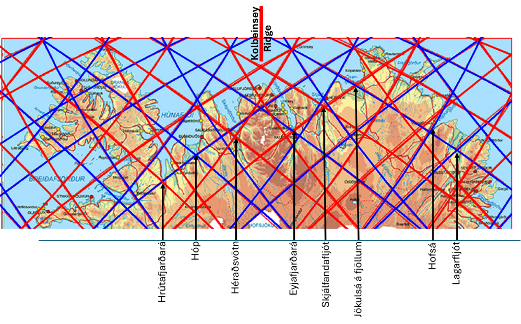
The ridge exhibits a pronounced north–south (N–S) orientation, and this same directional trend can be observed across much of northern Iceland. One of the most compelling expressions of this alignment is seen in the river systems. Major rivers such as Hrútafjarðará, Héraðsvötn, Eyjafjarðará, Skjálfandafljót, Jökulsá á Fjöllum, Hofsá, and Lagarfljót largely follow northerly courses, reflecting a structural control that is unlikely to be coincidental.
In addition to their general N–S alignment, these rivers display occasional deviations that appear to coincide with subtle structural boundaries or division lines in the crust. These interruptions in flow direction may mark transitions between different tectonic domains or the influence of underlying mantle dynamics.
The estuaries of these rivers further reinforce this pattern. Their distribution shows a striking regularity that aligns with the proposed grid of convection rolls beneath Iceland. Each estuary can be interpreted as forming a “hub” within this grid, suggesting that surface hydrology may be responding to deeper, organized mantle processes. This spatial consistency lends support to the idea that convection rolls patterns influence not only volcanic and tectonic features, but also the development of drainage systems.
A careful comparison of topographic and geological maps with the river network makes these relationships more apparent. The rivers are not randomly distributed; rather, they appear to trace out an underlying structural framework. In this sense, northern Iceland’s river systems may serve as surface indicators of deeper geodynamic organization (the grid formed by mantle convection rolls), reflecting the combined influence of the Kolbeinsey Ridge and broader mantle convection patterns.
