Uncategorized

Why is North America divided so drastically into East and West?

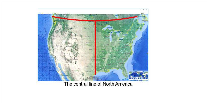
The United States of America are divided into two parts. So can we explain that further? Let us draw a NS-axis accurately in the middle.

The central line of NA

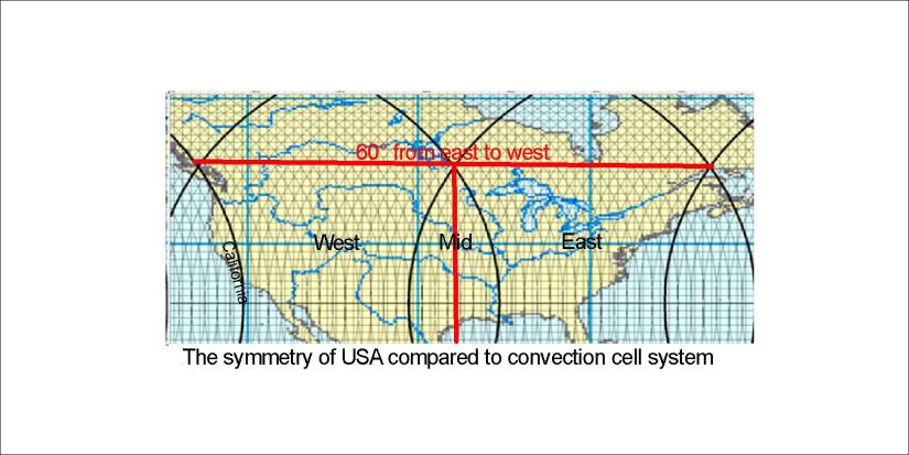
The contrast becomes clear with a single line. But the upper horizontal line is important. It spans exactly 60°. And the two corners are those of two hubs of the convection cell system. So here is the position of the USA:

US symmetry compared with convection lines

The path of the convection lines forms hubs where upper and lower cells meet with each other. So the coasts are actually found to lean to those two points. Just to show how detailed this marvelous coherence between the continent of America and the convection cells underneath is, have a look at this map:

US symmetry convection lines

This is how the North American continent is divided into two, or perhaps a few, parts.

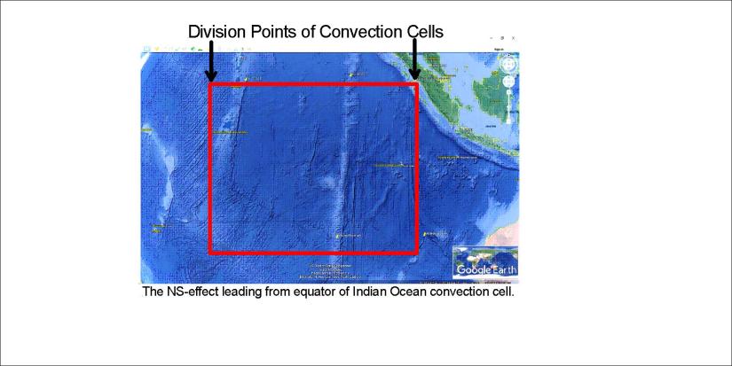
Probably someone does not understand the meaning of the lines drawn. The basics: A pair of parallel lines shows the location of one convection roll. There are two layers of convection rolls between 120-410 km depth. Below that, there are large convection rolls, marked with wider lines.

Uncategorized

Everyone can see Ninetyeast Ridge on a World Map, but how to explain it?

Looking at a World Map, a long ridge does decorate the Indian Ocean, called the Ninetyeast Ridge. It simply lies close to 90°E. It is not the only NS feature in the area, because the Chagos Trench is found west of it, forming a parallel. And there is a mystery:

Ninetyeast Ridge

This square is surprisingly regular, besides that the interval between Ninetyeast and Chagos along equator spans 15°. That is half the width of a large convection cell in lower mantle… So why is that? Actually we need one more step of investigation to understand a bit what is going on. There are more NS faults found east of the Ninetyeast Ridge, so they seem to be a part of the same piece in the puzzle.

The Indian Ocean floor Indian Ocean floor drifts to NE, a direction that does not seem to have anything in common with NS. Still, at equator the main division point between convection cells is found at the coast of Sumatra. Therefore this NS framework can be considered as spanning 30° along equator and showing its effect directly southwards due to NS symmetry of the convection currents.

Indian Ocean - East

This is therefore the holistic piece. The Central Indian Ridge forms the western edge of the framework. The eastern most suspicious NS lines are found extending from the division point of Sumatra coast of the equator line.

The equator plane is essential for the convection cell system. Therefore I add the division points map here:

World at equator - 01

Finally, to get a bird’s eye view of the surroundings of Ninetyeast Ridge and the relevant square, let us compare it with the convection cell division line main pattern:

World - Ninetyeast Ridge

This is the square, spanning 30° along equator.

Uncategorized

Hveragerði – where mantle division line does cross the tectonic division line

Hveragerði is a town surrounded with steam. Tracing the mantle currents, the town is found to have a very central location.

20180708_073434

Greenhouses of Hveragerði with steam from hotsprings in the background.

The main mantle division line is considered to be that of the deep mantle currents responsible for opening the Atlantic Ocean. A further analysis shows how the convection rolls above form a network providing circulation of magma material around the globe. The division lines of convection rolls of all the layers happen to cross under Hveragerði, including the main division line of the lower mantle. This makes the location so special.20180708_072905

What is found on the surface at Hveragerði…

Hveragerdi

What is found to be below…


Uncategorized

Langisjór – representing the Eastern Volcanic Zone

Langisjór is a world of its own, and so important to geology. As it is a very long feature, about 20 km, it shows the main alignment of the relevant volcanic zone quite well. The world’s mantle convection cells are arranged according to the formula used here, and it is exhibited quite clearly at Langisjór:

Langisjór - alignment

The accuracy is a proof that this is the correct way to compare surface features with the system of convection currents underneath, as shown in a previous post about Langisjór.

Uncategorized

Skógafoss – the regular A4 shaped waterfall

The most regularly shaped waterfall is Skógafoss, like an elongated page of a book. Let us have the same kind of analysis as for the the other famous waterfalls at hand.

20171227_105055

There was not much water in it during the winter time, but the edge of it can be clearly seen. From above the alignment can be measured and compared with calculated direction of convection rolls:

Skógafoss - 01

No surprise, because it fits exactly to the expected value.

And above Skógafoss there are at least 25 smaller falls within the Skógá river. Are they aligned according to a formula too?