Uncategorized

The 180° of Eurasia between Norway and the Bering Strait

According to the analysis presented here, equator and the parallel of 64°N have mathematically identical outcomes. Even though the rotation provides much more angular velocity at equator, special things appear at 64°N as well.

Mainland of Eurasia 180 at 64N - 02

Some would just show some reflex and start talking about something else, but there is a reason for this.

Norway - Bering Strait

The division lines between mantle convection rolls have a long term guiding effect for the tectonic drift, leading to these results.


Uncategorized

Connection between Tungnafellsjökull and Bárðarbunga volcanic sites

It has been noticed that rifts have opened up in the area of Tungnafellsjökull. At the same time, Bárðarbunga has been quite active. According to the layout of the grid of Munroe lines feeding the volcanoes, it looks likely that magma actually flows from the line through Tungnafellsjökull into the magma chamber under the caldera of Bárðarbunga. The flow would follow this arrow:

Tungnafellsjökull - Bárðarbunga

The magma did flow a long way until the eruption of 2014 in Holuhraun started. As shown in former blog post:

Bárðarbunga magma trail


Uncategorized

The Caribbean twins

Of course no one can answer this properly. The similarities are countless and both areas are formed due to the formation of the Atlantic Ocean. The island arches forming at the eastern margin are arranged similarly. The area marked on the map below is very well known as the Caribbean Sea.S-Ameríka - Skil norðan við

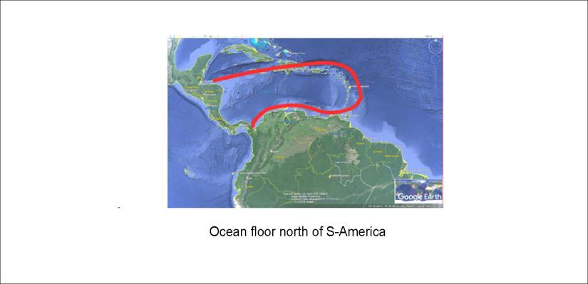
But south of S-America is a less known ocean:

S-Ameríka - Skil sunnan við

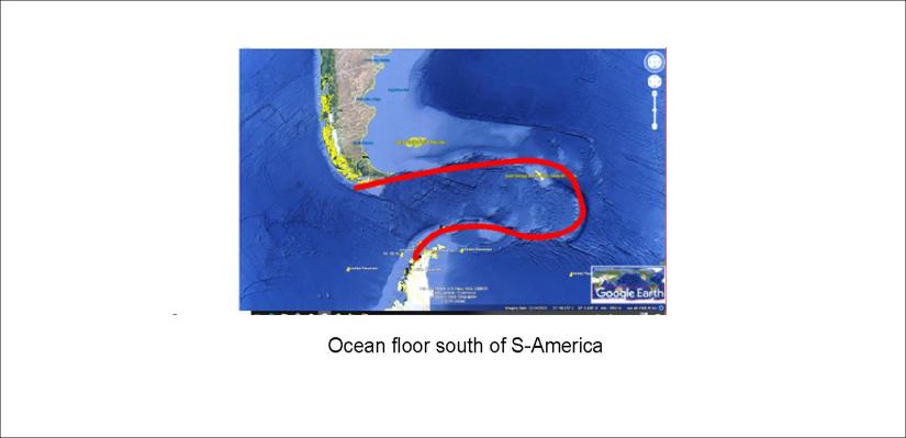
These two areas, somehow inserted into the Atlantic Ocean, are strikingly similar. The settings are comparable, at the outreaching ends of N-America, S-America and Antarctica, so we can have some kind of feeling for why the similarity occurs. One of many magic wonders!

So what does this tell us? The fact that this degree of similarity can occur, aligned exactly the same way compared to NS and EW axis, the interplay of tectonic drift and rotation of the Earth has to be very similar. Those traveling through S-America might also be interested in this. At least, if this kind of similarity would be found north and south of Iceland people would mention it. S-America is big enough to somehow keep this out of sight.


Uncategorized

Hidden eruptions under the glaciers

During this decade, a few volcanic eruptions have been recorded under a glacier without breaking through the ice. It has occurred twice under Mýrdalsjökull in South Iceland, both in the year 2000 and 2011. These eruptions are comparatively small and last for a short time. The effect is usually limited to a flood, and in 2000 the bridge over Jökulsá River withstood the extra flow. On the contrary, the flood of 2011 took the bridge over Múlakvísl River.

The floods find their way under a glacier tongue, and this is a picture taken on the middle of Sólheimajökull where the flood of 2000 took place.

20180729_162421

On the top, black basaltic sand and volcanic ash covers parts of the ice. The river Jökulsá flows peacefully down below.

Sólheimajökull og Kötlujökull - flóð

The location of those two floods / eruptions are roughly pointed out on this map from Náttúrfræðistofnun of Iceland, with the convection cell grid added.