Uncategorized

The Mid-Atlantic Ridge zik zak

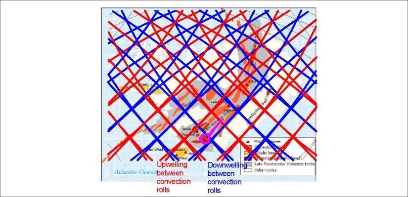
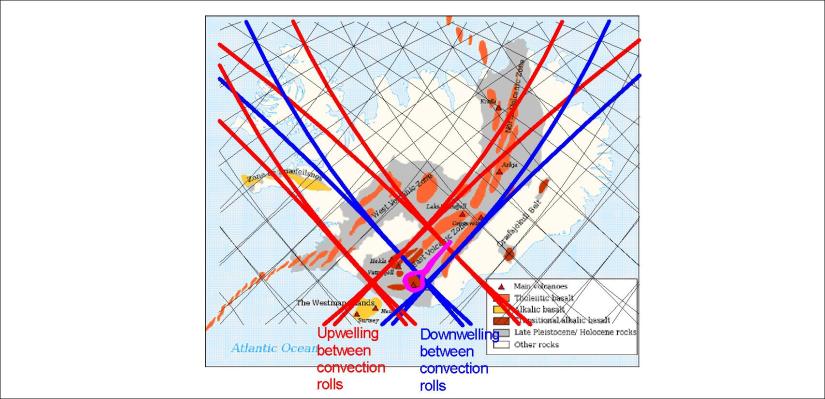
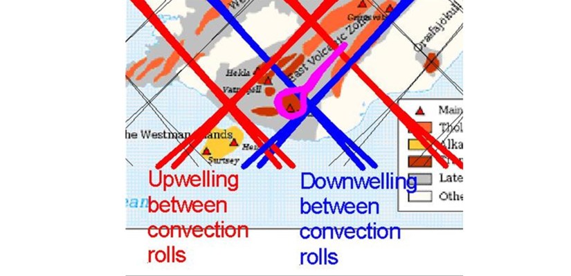
The Mid-Atlantic Ridge sways rather regularly throughout the N-Atlantic sea bottom. The two large convection rolls which must be found at each side of it, can not make jumps or sway irregularly, becuse it is composed of flowing mantle. It must therefore be shaped according to the Earth’s radius and in coherence with the rotation of the Earth.

Mid-Atlantic Ridge - the zikzak

The crossing between mantle division line of the large cells and the Mid-Atlantic Ridge is found at 32°N, which is where the mantle rolls division line is exactly oriented NS.

The magma flow therefore tends to find its way west of the central line in southern latitudes, but east of it north of 32°N. Then it follows the middle line closely along the Reykjanes Ridge, following the next upwelling line east of the main line.

Again, at equator, the two lines merge into one.


Uncategorized

Following the grid, understanding the geology of Iceland – and the World

The map shows it all 🙂 The volcanic sites in Iceland are arranged in a systematic way. First, the Reykjanes Ridge is found along a calculated line extending through the middle of the Atlantic Ocean, with a starting point at equator exactly 30° awy from the coast of S-America on one side and 30° from the coast of Africa on the other side. Then the grid shows how the tectonic plates meet in Iceland. One aspect is the NS-axis from Öræfajökull to Öxarfjörður. Then the Tjörnes Zone in the North shows very clearly the function of the polygon system over Iceland.

Following the grid

It can not be more clearly manifested. Explaining in this way the geology of Iceland makes it easier for comprehend the volcanism, geothermal activity and the geological history of Iceland. With the mechanism in mind, and when everything can be calculated mathematically, it becomes easier to trace changes back in time.


Uncategorized

The upwelling and downwelling lines of Iceland

Downwelling means a tendency to converge, and upwelling means divergence. The small scale convection rolls intervene with the main trend following the large convection cells of lower mantle. That main line lies through the middle of the country from SW to NE. The two southern volcanic zones, called WVZ and EVZ, are found within the same settings, namely with upwelling to the west and downwelling at the eastern side. The reason is conflict between the tectonic drift to the NW and the opposite trend resulting from the upwelling and downwelling lines.

Upwelling and downwelling

The MIVZ in central Iceland actually also has this setup, but to the NE and SW. The shift of tightness of the polygons at 65°N results in almost continuous volcanic areas from Snæfellsjökull to Snæfell. Then there is the NS-axis from Öræfajökull to Axarfjörður, besides the less known NS axis from Eyjafjallajökull through Hekla to Drangey.

Uncategorized

The Katla Volcanic System

How to explain the existence of the EVZ and Katla volcanic system? We can analyze it by looking at the convection cell system, its lines and polygons. Katla takes over two polygons as shown here:

Katla Volcanic System

The four lines are all downwelling. The caldera is found in the east corner of the southern polygon. When magma finds its way out of the caldera, it flows along the fissures exactly from one side to another of the northern polygon. The tension is created by the conflict between large scale tectonic drift, pulling from NE to NW, and the small scale (1.5° wide) pulling of the uppermost convection roll under the EVZ from NW to SE.

To see this more clearly, zoom in a bit:

Katla - hyrningar - þysjað

The violet color shows Katla Volcanic System, both caldera and the fissure swarm extending to the NE. The other fissure swarm, extending from NE to SW, is the Grímsvötn system, where the caldera is also found adjacent to a corner of the relevant polygon.


Uncategorized

The North Volcanic Zone of Iceland

The North Volcanic Zone is differs from the WVZ and EVZ in the south. It is aligned directly NS as a whole, but individual volcanic systems point slightly to the NE. Comparing the grid to the map of National Land Survey of Iceland gives this picture:

Drift - North Volcanic Zone

The vectors of tectonic drift as mesures for ISNET 2004 are divided around the NS-oriented NVZ. By marking the main polygons of the zone red, the main volcanic areas are seen to be found within them, thereby functioning to meet the tectonic drift as these polygons break up, making space for more magma input from below.

The directional effect on tectonics resulting from diverging to the east and west on the polygons is thereby quite obvious.