Blog

Uncategorized

Comparing Hornstrandir with Austfirðir

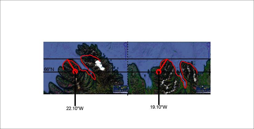
The eastern part of the NW-Peninsula and the Eastern Fjords of Iceland show remarkable resemblance. In addition, the angle between them is 44° of rotation, and the points of rotation are exactly 6° apart on 66.5°N and 64°N respectively as shown here:

Vestfirðir og Austfirðir - samanburður

How can different parts of Iceland be replicas of each other? The answer must be found in the coherent mathematics and information about tectonic drift.

The sections are so alike that the north end of them both have the same name: Kögur.

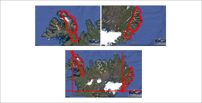
As shown in previous posts, the middle part of the Western Fjords Peninsula has a similar shape as the Tröllaskagi peninsula. When mathematical preconditions repeatedly manifest themselves, showing clear resemblance with real circumstances, it becomes a proof of relevance of the background theory.

Uncategorized

Comparing Tröllaskagi with Vestfirðir

It is amazing how the process of shaping the surface has resulted in similarities at different locations. Look at Tröllaskagi compared with the peninsula of Vestfirðir. Noticing that Ísafjarðardjúp has the alignment of equatorial mantle convection cells while Eyjafjörður has the direction of polar cells, the difference is about 22° of rotation for a match. In addition, the east coast of Skagafjörður and Arnarfjörður also match together. To trace the history of those two areas is a job for Superman.

Tröllaskagi compared with Vestfirðir

Actually, the fit itself is not the mane issue here. The main issue is that this resemblance could be systematically searched for, because the rotation points are exactly 3° apart, representing the distance between the division lines of two convection rolls along the parallel of 66°N. At those two locations, similar conditions of mantle convection cells should prevail.

Uncategorized

The twin fjords of Ísafjarðardjúp and Eyjafjörður

The two fjords Ísafjarðardjúp and Eyjafjörður are twin fjords. The shape is identical and their openings are on the same latitude.

It can be shown how the fjords have rotate around identical points 3° of longitude apart.

Ísafjarðardjúp og Eyjafjörður

The direction of the vectors from the point of rotation is the same as the calculated value of convection cells at 66°N, that is N33°E and N33°W. The rotation angle of Eyjafjörður compared to Ísafjarðardjúp is 22°, the same as the difference between equatorial and polar convection rolls alignment at the latitude.

A coincidence of this degree of mathematical coherence is virtually impossible.

Uncategorized

Distance from Snæfellsjökull and Snæfell to division line is equal

The fascinating symmetry of the convection cell system appears in this drawing:

Snæfellin 02

The mountains Snæfellsjökull and Snæfell have the same distance to the division line from Ölfus, over Hveravellir and to Skjálfandi.

To emphasize further on the regularity, look at the position of Hekla:

Snæfellin 01

This is one of many proofs of the existence of the system of mantle currents.

Uncategorized

The EW-alignment of Eyjafjallajökull, and the position of Seljalandsfoss

Eyjafjallajökull had everyone’s attention in 2010 when it erupted and spread volcanic ash over Europe. This mountain shows clearly how the forces underneath shape the surface of Earth. The perfect EW-alignment is exaggerated by a regular elliptical form, and the adjacent area of Þórsmörk and the river Krossá follow the same trend. Eyjafjallajökull’s top crater is on the NS-axis of its polygon of convection rolls division lines. The waterfall Seljalandsfoss then faces the West along with Gljúfrabúi and other smaller waterfalls at the westernmost end of the Eyjafjöll area. In the south of Eyjafjöll, the waterfall Skógafoss shows the effect of the NW to SE trend, with its edge aligned N41°W, the same direction as the frame of the convection cell polygon at the latitude of 63.5°N. Here I have lined up some of the features on a Google map:

Eyjafjallajökull - EW alignment