Blog

Uncategorized

The lakes of Finland

conifer daylight environment evergreen
Photo by eberhard grossgasteiger on Pexels.com

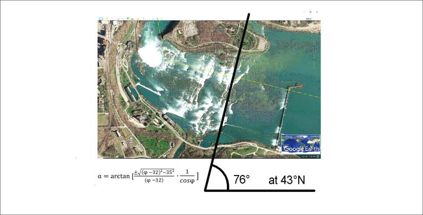
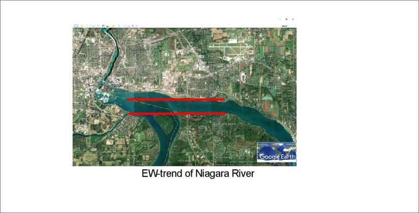
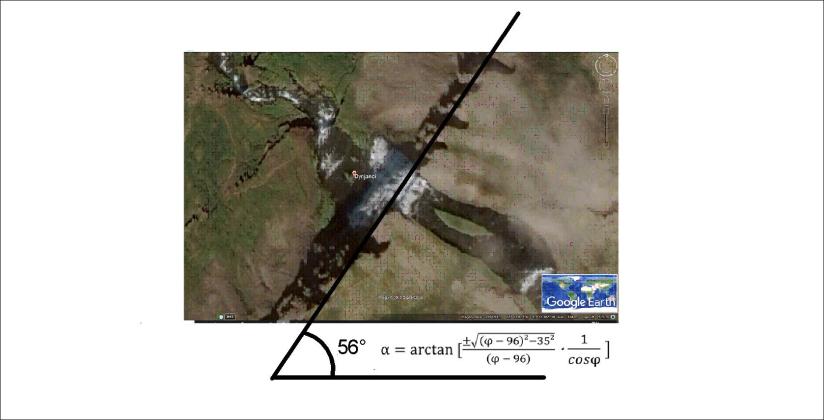
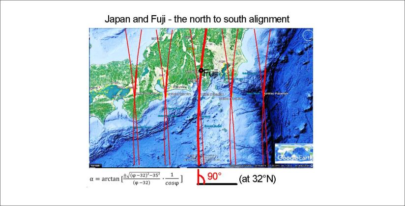
Finland is a country of lakes. The glacier of the ice age did dig out these sites of peaceful surroundings. One can easily find a certain direction many of the lakes follow. Calculating according to Coriolis Effect the path of mantle convection rolls fits exactly to this alignment. This can be shown on the base of a Google map:

Finnland - 01

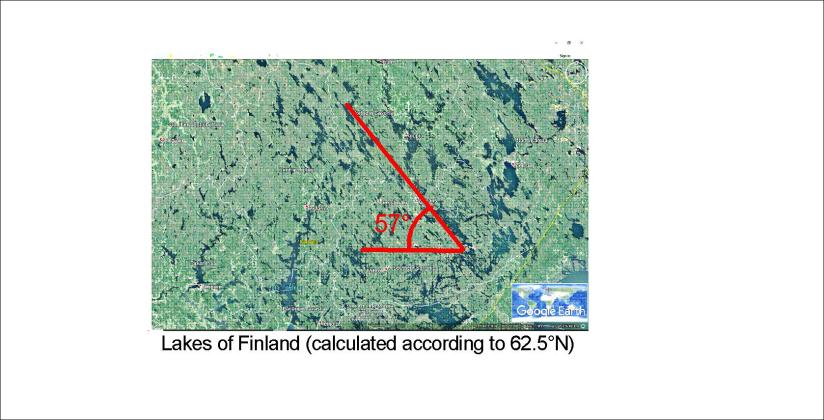
It is just amazing how accurately these calculations fit for tectonics and topography.

This can be calculated because the convection rolls sway according to the difference of rotation speed of the Earth from one latitude to another in a perfectly regular way. This is the same effect as governs the path of wind and sea currents. The mantle under Finland has made way for the glacier in harmony with the alignment of convection rolls.

holidays car travel adventure
Photo by Mihis Alex on Pexels.com
Uncategorized

Earth and Mars – can they be compared?

The largest shield volcanoes on Earth and Mars are exactly on the same latitude (18.6°N). Mauna Loa, Loihi and other volcanoes of Hawaii and the huge Olympus on Mars are found there. Let us compare the planets accordingly:

Earth and Mars (Hawaii and Olympus)

I got this map of Mars from http://mapgame.wikia.com/wiki/File:Mars_map.jpg

Of course this is an indication that Earth and Mars have hot spots formed in an identical way. Planets should have a tendency to form the same kind of convection rolls system.

This comparison fits also quite clearly for Ascraeus Mons, another shield volcano on the next convection rolls division line east of Olympus. Anyway, someone familiar with geology on the planet Mars could make this comparison.

white space ship and brown planet
Photo by SpaceX on Pexels.com

If the convection cells systems for Earth and Mars are identical, the grid lines of longitude for Mars have been shifted about 22° to the east, as can be seen on the picture above.

To keep our feet on the ground, here is a picture from Hawaii. This also happened on Mars billions of years ago.

erupting lava during daytime
Photo by Pixabay on Pexels.com


Uncategorized

Niagara Falls – origins of the Horse Shoe and the American Falls / Bridal Veil Falls

Looking at waterfalls is wonderful. We can also try to get some insight into the real background of these special sites, visited by so many people.

niagara falls in canada
Photo by Tomas Anunziata on Pexels.com

The Niagara Falls begin with a gentle slope in Niagara River. It follows the calculations:

Niagara 01

This is achieved by direct calculation, which means that the upper most part of Niagara is aligned i the same way as the convection rolls of the mantle underneath.

The tectonics of the waterfall itself can also be calculated:

Niagara 02

There is a reason for this proportion, namely balance between convection cell alignment and the tectonic EW-axis in the area.

The EW-axis even appears quite clearly:

Niagara 03

Agree? OK then 🙂

The difference between the angles of tectonic lines becomes 19°, that is 1/4 of the angle of convection rolls compared with the EW-axis.

It is a coincidence that the tectonics of the Golden Waterfall in Iceland are also calculated in this way.

Complicated? Geology, geophysics, tectonics… these are quite difficult subjects. What I am showing here is almost embarrassingly simple in comparison to many things found in basic textbooks of those subjects. This is new, and the work leading to these calculations was complicated, but not using the method once it is here is very easy.

Uncategorized

Dynjandi – another tourist spot of tectonics – calaculated!

beautiful cascade environment fall
Photo by Ghost Presenter on Pexels.com

Dynjandi, a mighty waterfall, is located in the Western Fjords area of Iceland, far away from the volcanic zones. Still the orientation of the waterfall can be calculated in the same way as the volcanic zones:

Dynjandi - 02

It is located on 65.7°N, about the same latitude as Dettifoss. So those two waterfalls are aligned the same way!

Just have a look:

Dettifoss - 01

So is there a basic reason for this?

Uncategorized

Japan and the location of Fuji

black and white mountain over yellow white and blue sky
Photo by Pixabay on Pexels.com

Mount Fuji is located on a triple junction between three plates. It should explain it all, besides the vicinity to the Pacific Plate descending into the mantle. But compared to the convection cell model, the position is unique. Fuji is located directly on one of the division lines of the lower mantle as shown here:

Lines - Iceland - Japan

Now we zoom in on Japan to show more details. It is interesting that the convection cells are aligned directly NS at 32°N, and Japan is just north of that parallel, so here is an example of how it works:

Japan - Fuji - 01

This line is a counterpart of the main division line under Iceland:

Iceland division line

As has been pointed out in other posts, this line represents both the main convection division at 410 km depth, and the upper most division line of small cells at 120 km depth. The smaller cells are down-welling, and the two lines to each side of course up-welling.

Therefore, in Iceland, The Reykjanes Ridge is found west of this line, whereas Hekla is east of it. Still, many volcanic and geothermal sites are also on the main division line, with the controversy of having up-welling deep below, but down-welling in the upper layer.

This is of course in a way complicated, but it is easy to see what Japan and Iceland have in common according to this model of the convection rolls within Earth’s mantle.