Blog

Uncategorized

Can we make use of our knowledge about Earth’s layers to anticipate the Moon’s structure?

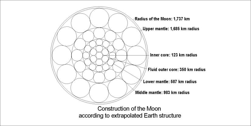
Is it possible to use what we know about Earth to find out more about the Earth’s Moon? At least we can extrapolate the proportions of Earth’s layers and see whether that fits for the Moon. It looks like this:

Tunglið 03

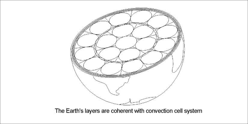
This is a guess, but it fits very well, and is in coherence with the convection cell theory.

What is new in this is claiming that the inner core has the radius of about 123 km. The other layers have been measured according to Apollo seismic data.

Extrapolating in this simple way is of course a bold method, but what we begin with is this picture of the Earth:

Earth askew - equator

As long as direct measurements are not violated, this can be seen as a valid contribution to the discussion. As far as I know, the diameter of the Moon has not been measured directly yet. Inge Lehmann found the inner core of the Earth in 1936.

Uncategorized

Earthquakes on Reykjanes Ridge – perpendicular to the ridge itself?

Earthquakes can tell a story. The The Icelandic Met Office provides information about earthquakes in and around Iceland. The earthquakes which occurred yesterday (15th of July 2018) on the Reykjanes Ridge make up a row perpendicular to the ridge itself.

Skjálftar á Reykjanesi 15-7-2018

I added a line showing the calculated angle of the lower convection cell layer. this type of alignment often occurs, more and less unnoticed.

Just for comparison, the convection cell grid is shown here on a map from the Icelandic Met Office to see how it works.

Skjálftakort með grind - Reykjanes      
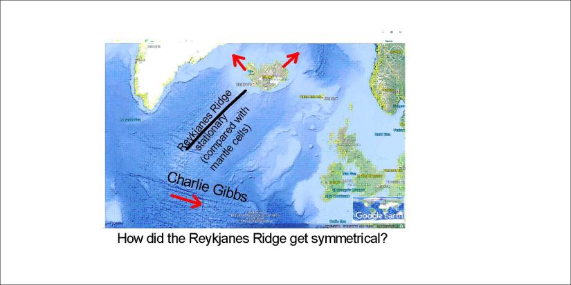
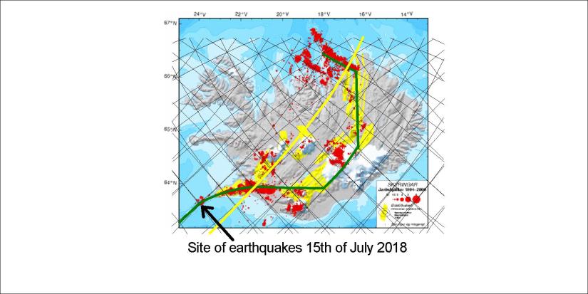
This is the site of an intersection point between polygons, where the Reykjanes Ridge makes a slight turn towards the Reykjanes Peninsula. South of this point, the Reykjanes Ridge follows the convection cell line.


Uncategorized

Siberia – the other border between Eurasian Plate and N-American Plate

In Iceland divergent boundaries between plates can be watched directly. Plates also meet in Siberia, but in much more obscure way. Map showing the exact location is hard to find. There should be similar logic everywhere for boundaries between tectonic plates, so let us check Siberia:

Siberia - division - theoretic

The so called MORVEL model shows most plates location, so please compare it to what is shown here. The exact comparison can then be made in a similar way as for Iceland where every detail of how the plates are deviding from each other can be traced accurately with the mantle convection cell model.

Uncategorized

What if we look at Australia as a puzzle?

Each continent has a position in dynamic puzzle of Earth. Here is Australia:

Ástralía 01

At the latitudes where Australia and Antarctica split apart a 100 million years ago, close to 60°S, Australia would span 60° from east to west. Drifting northwards with the role of a puzzle it maintains the shape of the time when it split apart from Antarctica. Scientists can then easily “play back” the continental drift to the exact position where the division process took place. Looking forward to it.

Uncategorized

How did the Reykjanes Ridge become symmetrical?

Considering that Iceland has symmetrical drift vectors, pointing NE and NW respectively, how did the Reykjanes Ridge get mirrored magnetic anomalies compared to its axis aligned NE-SW? We can have a look into it:

Landrek - Ísland 01

The rotation of N-American and Eurasian plates (along with Africa) is rather symmetrical and in coherence with the directions found in eastern and western parts of Iceland. If these vectors were prolonged along the Reykjanes Ridge, this would make no sense. The puzzle is dynamic, and whereas the Charlie Gibbs Fracture Zone can explain the discrepancy, another drawing on a map is added:

Landrek - Atlantshaf

If the Reykjanes Ridge remains stationary over the relevant division line between upwelling convection rolls, when the sea bottom south of Charlie Gibbs is shifted eastwardards compared to the convection cell system, then the Ridge can be regular. When it comes to Iceland, a similar shift is found in Southern Iceland, and in Northern Iceland the division line is directed NS.

If this mechanism is active, it should also be measurable. In the South Atlantic, the ridge is mainly NS oriented.