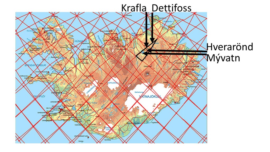
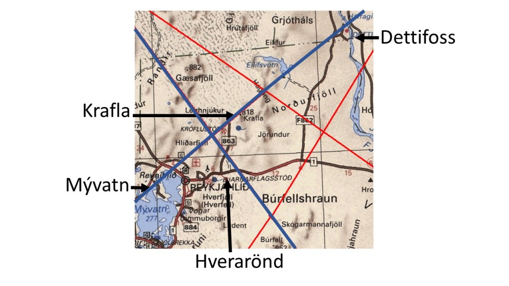
Blog

Uncategorized

How the Pacific Ocean Tectonic Plate Works

The huge Pacific Ocean Plate moves fast westwards, and the reason is flow of mantle material. But how? Many convection rolls participate in moving the plate. The rolls moving in the same direction as the plate must be more coupled to the plate than those opposing the dirft direction. Thereby, the drift can be maintained over this huge distance. The small rolls, spanning 1.5° from east to west are mainly responsible for the direct force applied on the plate, but large scale trend is ruled by the large scale rolls underneath.

This can be shown with a section of the equator plane seen from the north.

The Pacific Ocean Convection Rolls Lines

View Post

The Pacific Rise along equator has, at first sight, an opposite flow direction to the drift direction of the plates, but the Pacific Plate is pulled away by the large section west of it, and the Nazca Plate is then the counterpart drifting to the other direction, namely to the east.

So the Pacific Ocean conceales the system below by not having formed a ridge where Hawaii is located. At first sight, The ridge should have formed there, with a whole plate reaching S-America, and the other half extending to Japan. If it was like that, the system above would have been realised a long, long time ago, when the ocean ridges were first mapped.

The 30° step pattern along equator has been mentioned here several times. It is more obvious for S-America, Atlantic, Africa and Indonesia. The Pacific Ocean division points are found at other latitudes, but easily comparable, and the starting points of S-America and Indonesia are of course in common with the end points of the ‘coast – 30° – coast – 30° – ocean ridge – 30° – coast – 30° – coast – 30° – ocean ridge – 30° – coast – 30° – coast – 30° pattern’ from S-America to Indonesia.

Convection Rolls in East Pacific Ocean

The down-welling line in the middle is also responsible for Juan de Fuca, so between Hawaii and N-America there is mainly only one convection roll found of 30° from east to west.

Uncategorized

The Relationship Between Japan and Hawaii of the Western Pacific Ocean

Fuji in Japan and Hawaii have similar relation to the main division lines of lower mantle. Therefore they are found 60° apart, as shown on this drawing:

Japan and Hawaii

Both areas are located on up-welling lines. The main chain of Hawaii spans 30° from east to west, from Hawaii Island itself to the southern end of the Emperor Chain. The background of that turn is therefore more complex than most people think (the common explanation that the tectonic drift just made a turn one day due to changes elsewhere). Today, the Hawaii chain seems to be developing southwards. The drawings of convection rolls represents a vertical section of the rolls. The ridge extending south of Japan is therefore one of the main manifestations showing the location and shape of the convection rolls within the mantle. The detailed analysis has to be made with the map of the upper-most convection rolls, understanding the implications within the volcanic areas of Japan and Hawaii Islands. But with this general section in mind, the exceptional volcanism of Japan and Hawaii becomes much easier to understand. Note that the volcanism in Hawaii has to be explained according to at least two small scale rolls, spanning 2×1.5° from east to west. The volacanism is found where certain conflict is found between the large scale convection roll of Central Pacific and the general tectonic drift direction. Once the sea floor is pulled over to the convection roll west of the volcanic islands, volcanism ceases.

Uncategorized

Fuji on a Main Division Line of Lower Mantle

Mt. Fuji in Japan is a symbol of all volcanoes, and is very strategically located on one of the six main up-welling lines of the World.

Fuji is located on up-welling mantle line

The ridge south of Japan follows the line accurately.

Fuji and the convection rolls division line

This shows that the trench system spans 3° from east to west, beginning with a local down-welling of upper mantle at 120 km depth, and the seafloor seems to be engulfed by the main division line of lower mantle, resulting in shaping the western edge of the ridge, besides Mt. Fuji.

The local upper mantle down-welling line is directly above the large-scale lower mantle up-welling line, resulting in a contraversy between large-scale tectonic drift and local trend.

Uncategorized

Indonesia Along Equator

Another example of how the topography follows the division lines of convection rolls along equator is Indonesia. It spans 30° from east to west, just like South America. Also, the two points of east and west have exactly the correct position as compared to S-America. We find steps of 30° around the world!

Indonesia along equator line spans 30° from east to west

So this pattern is obvious. The up-welling line is found at the western point of the 30° string, extending farther to the south where you find Krakatoa, one of the most famous volcanoes in the world. Therefore, behind the trench and relevant geology, there are geophysical preconditions we should look into.

Equator Plane with S-America and Indonesia

The string length along equator over S-America and Indonesia is exactly the same. Both span 30° out of the 360° of the whole of equator. Besides that, the two strings are found exactly opposite to each other as shown in the drawing above. It should be enough just to point this out, so everyone can see that this can be no coincidence. This distribution is also consistent with the convection rolls model, with the width of the convection rolls underneath being the same as the height. By noticing this, we add to our possibilities to understand the functions of the Earth, on which we live.

Uncategorized

The Amazon Area of South America

The Amazon basin is aligned predominantly west–east, and the Amazon estuary lies on the Equator. According to the convection-rolls model, this estuary is situated on a major downwelling division line between large lower-mantle convection rolls.

In addition, 30° westward along the Equator from the Amazon estuary lies the west coast of South America, where a deep oceanic trench is present. This trench corresponds to another division line of large scale lower mantle convection rolls associated with the implications of uppermost mantle convection rolls of the asthenosphere.

South America Spans 30° along Equator Line

South America spans roughly 30° of longitude along the Equator, from the Amazon estuary to the Pacific margin. This is followed by an approximately 60° longitudinal span along the Equator across the Atlantic Ocean to Africa (with the Mid-Atlantic Ridge in the middle, and therefore we have two 30° steps across the ocean), and then a further 30° span from the west coast of Africa to the Great Rift Valley. At each of these longitudinal intervals, a division line between major lower-mantle convection rolls can be identified.

The Amazon River, marked approximately by a blue line, closely follows the equatorial parallel and appears to be structurally guided by this deep mantle boundary. This spatial correspondence suggests that large-scale mantle convection geometry exerts a first-order control on continental-scale river systems, plate boundaries, and major tectonic features.