The Tjörnes Fracture Zone combines the North Volcanic Zone with the Kolbeinsey Ridge. The alignment of epicenters follows the mathematical model of convection rolls closely. Today, the ‘Met Office’ map looked like that:
Epicenters of TFZ 17-8-2020
Comparing with the convection rolls model shows how the SE-NW alignment follows the division line, whereas the N-S aligment does trace the central axis of the polygon marking the very beginning of Kolbeinsey Ridge.
Seismic activity of TFZ 17-8-2020
Besides that, Grímsey is pointed out. Grímsey Island is the northern most inhabited part of Iceland. It is found close to a ‘hub’ of division lines of different layers, leading to an anomaly of volcanic and geothermal activity within the surrounding area.
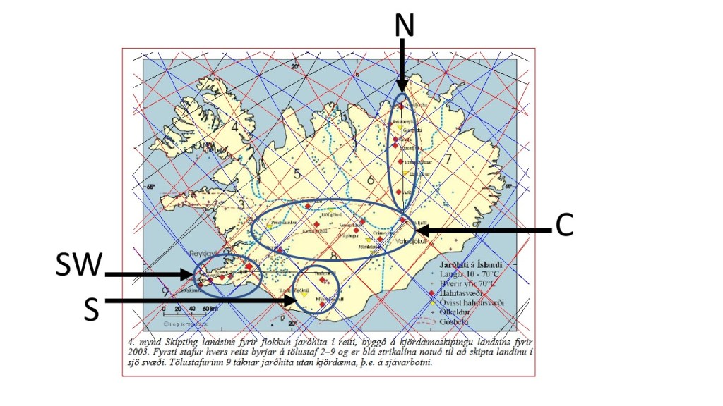
The high temperature areas in Iceland can be divided into four, rather distinct, areas. Here they are marked with SW = southwest (Reykjanes Peninsula), S = South Iceland, C = Central areas, and N = North Iceland.
SW: Reykjanes consists mainly of one polygon, with Svartsengi on a division line, and also Hengill, but the other three areas of Reykjanes, Krýsuvík and Brennisteinsfjöll are found on the tectonic division line between N-America and Eurasia.
S: These areas are found to the SW of the main rift zone of Iceland, East Volcanic Zone.
C: This is the largest area. The hight temperature areas are found at the main crossings found between the division lines, therefore forming a rather regular pattern. This consistency between division lines and high temperature areas is one of the proofs of the existence of the division lines surrounding the polygons.
N: These areas form a line oriented directly N-S. Two of them are strictly originated from the tectonic division line, besides being centrally located within the relevant polygon, namely Askja and Fremrinámar. The others are found in context with the Mývatn hub of small polygons. Öxarfjörður is here classified as high temperature area, being exactly at crossings of convection rolls division lines and the tectonic N-S division line.
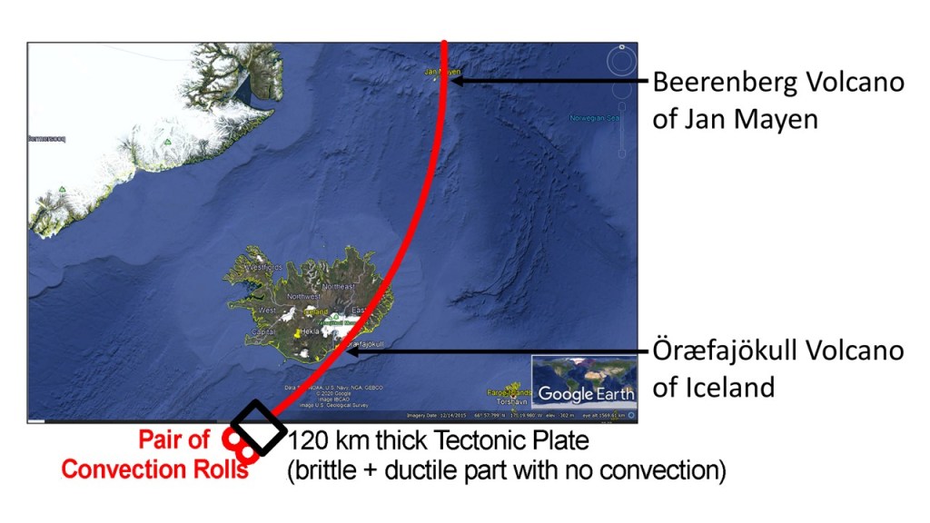
Jan Mayn is a part of the same volcanic structure as Iceland. It can be shown by pointing out the pair of convection rolls connecting the highest volcano of Iceland, Öræfajökull, with the volcano of Jan Mayen, Beerenberg.
The two scenic spots of Þríhnúkagígur and Leitin are found near Reykjavík. The former is a crater with an empty magma chamber underneath. Now it is possible to enter the resulting cave, one of its kind in the world. The second is a crater very few people visit, but the lava from it created the Raufarhólshellir lava tube, known as the Lava Tunnel in tourism. It also created Rauðhólar pseudocraters and Tröllabörn hornitos in the same eruption, over 5000 years ago. Both craters are found along the mysterious 64th parallel.
Comparing convection rolls and real time events is one aspect of looking into the details of the magma currents. Earthquakes along the line extending from the Reykjanes Ridge follow very similar pattern. The earthquakes occur on lines crossing the RR extension line. The green stars show earthquakes over 3 on Richter scale.
Earthquakes compared with convection rolls division lines.