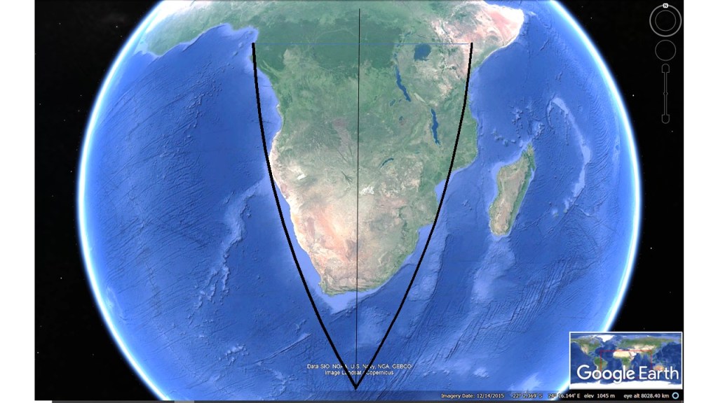
Our Earth looks beautiful seen from space, and one reason is the symmetry of continents and oceans. Africa is the best example, as the southern half of it is explicitly picturesque. It is no coincidence, as is shown here below.
The symmetry of Africa.
The lines make it already a little bit easier to appreciate the symmetry. Taking the mantle currents into account, we get this drawing showing the basic situation:
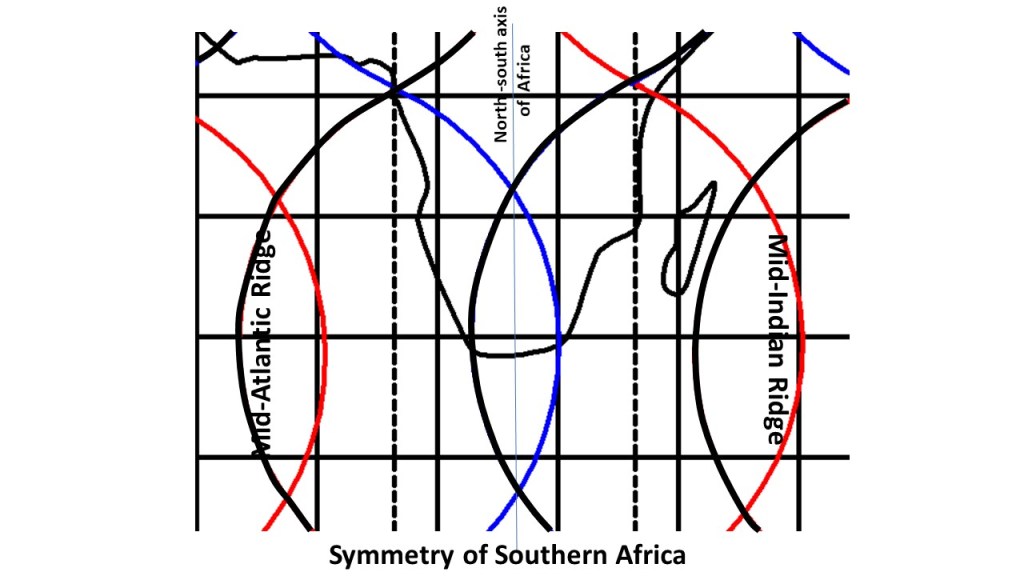
The symmetry of Africa compared with convection rolls division lines.
This shows the main lines of the position of Africa compared with the mantle currents. A north-south axis forms in between the two ridges of the Atlantic Ocean and the Indian Ocean, being roughly 60° apart at these latitudes. This location over downwelling (blue) lower mantle division line is making the continent relatively stationary during this geological era. Upwelling lines of lower mantle are marked with red.
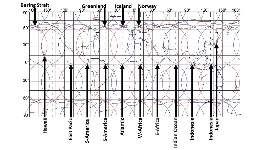
The world has a distinct pattern, as shown below. This is due to the effect of mantle currents.
The World Pattern.
Apart from the 30° steps along equator, the convection rolls pattern explains the volcanic activity of Hawaii, Japan and Iceland.
Although obvious, the pattern has to be explained. The large scale convection rolls span 30° from east to west, and sway in an ‘S’-shaped way along the globe from north to south. Besides that, the magma circulates, not only within each section of the relevant convection roll, but also horizontally around the globe. To put it simple: If not, the system would not work.
The points selected here with arrow all need special attention. How did the Bering Strait open up? How does the volcanic activity of Hawaii work? The answer is that Hawaii is located over the division line of two large scale convection rolls. The East Pacific main ridge is close to the point pointed out with the arrow here, but there is a smaller ‘side ridge’ at the division point between large scale convection rolls. The west coast of S-America is a prominent point, with a huge trench. Then the Amazon delta is also one of the most decisive equatorial points of the convection rolls system of the Earth. The long stretch of Mid-Atlantic Ridge along equator has of course a point at the center of the ocean, pointed out here. Then, 30° farther eastwards is the west coast of Africa. Going 30° to the east from there, you will see the Great Rift Valley of Africa. Another 30° to the east, the Mid-Ocean Ridge of the Indian Ocean is found exactly where it should be according to this model. Going farther, namely 30° to the east, the west coast of Indonesia provides the base for the next point. Travelling 30° over Indonesia, you will reach the eastern coast. To explore the next division line between convection rolls, it is best to see Japan, actually Mt. Fuji, the most famous volcano of Japan. To further convince oneself of the sensibility of this system, we should have a look at Greenland, Iceland and Norway, providing a pattern over the North Atlantic. The model of the world is so inaccurate that the details cannot be detected, but luckily, I have worked them out also. It is always possible to ‘zoom in’ on each location to analyze in detail what really happens there, when doing so, the interaction between different layers of the mantle can be considered, and you will feel everything starts making more and more sense.
Because how obvious this is, everyone can accept the idea that large scale convection rolls shape the world. As can be seen in other posts, there are countless examples of the tiny details which can be explained with this model.
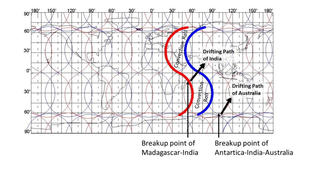
The breakup of Antarctica, India and Australia can be traced accurately, and here we look a bit further into the process. India ‘left’ Madagascar behind on its way towards Eurasia, and the responsible forces down below can be analyzed as shown here:
The breakup of Antarctica, India and Australia
The convection roll forcing India to cross equator is marked specially with wide red and blue lines. After entering the area above the adjacent large scale convection roll, India turns anti-clockwise.
Australia, on the other hand, follows a northern trend within a single convection roll. The eastern edge is confined with a downwelling division line, shaping the mountain range on that side.
The Indo-Australian Plate does therefore move in the same direction. Note that upwelling and downwelling of large-scale convection rolls does not govern tectonic drift directions. The direction is determined much more randomly, and once on the plates move along a certain path, the opposing small-scale convection rolls get decoupled and the pro-active convection rolls tend to get coupled to the tectonic plate bottom. It is easy to see though, that the alignment of convection rolls is a ruling factor for the drift direction of India and Australia for the last 50 Ma.
The lowest point of Earth is found at the Dead Sea, so some particular conditions must be prevalent there. Looking at the mantle convection pattern, some explanations can be made.
North-South alignment of convection rolls within the Mediterranean.
The main division line, as defined here, is actually at the western margin of the Nile Delta. This particular main division line, marked with slightly wider red line than the others, is not of a single origin, according to the convection rolls model. First, it is a main division line of the convection rolls of the outer core. Second, it is a division line of the lower set of convection rolls found between 265-410 km depth. The rolls of the upper set (between 120-265 km) and the lower set interact, as the division lines almost coincide at these latitudes.
The Nile is kept in an incredible way on its northwards path with this system, and the main part of the delta is found in between two cooperating downwelling lines. Farther to the east, this combination of convection rolls marks the beginning of the Great Rift Valley system with the Dead Sea fault line. As can be seen, the relevant upwelling division line is quite parallel to the Dead Sea fault, but is found slightly west of it, except at the intersection point of the upper and lower convection rolls, where the rift system shifts to the west of the convection rolls division lines.
The Aegean Sea is a famous part of the Mediterranean, where the African Tectonic Plate meets with the Eurasian Tectonic Plate. Description of the geological features can be seen here: https://en.wikipedia.org/wiki/Aegean_Sea_Plate
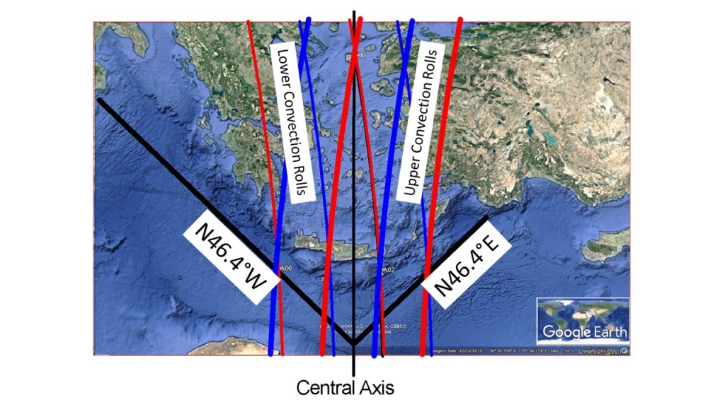
Symmetry of the Aegean Sea
Apart from the deep understanding the Aegean Sea geology already found in scientific articles, the convection rolls pattern tells an untold story. The two trenches (Hellenic Trench and Strabo Trench) are accurately symmetrical, as shown here, aligned 46.4° from north. A closer look would lead to the conclusion that the edges sway a bit. The alignment can actually be pinpointed with calculation, being the alignment (from east and west respectively) of a tectonic roll of the relevant latitude divided with two. The central axis is formed in between convection rolls division lines, marked with intersection point of the northern part of the Sea.
The Mediterranean Sea is characterized by north-south oriented convection rolls, and along the 32nd parallel, the alignment er exactly N-S. This leads to the rather unique symmetry of the Aegean Sea.
The relevant convection rolls are shown superimposed on the Google Earth map. Red lines stand for upwelling between rolls, blue lines stand for downwelling. The upper set of rolls is drawn with slightly wider lines, the lower convection rolls have thinner lines for marking the divisions between them.