The world has a distinct pattern, as shown below. This is due to the effect of mantle currents.
Apart from the 30° steps along equator, the convection rolls pattern explains the volcanic activity of Hawaii, Japan and Iceland.
Although obvious, the pattern has to be explained. The large scale convection rolls span 30° from east to west, and sway in an ‘S’-shaped way along the globe from north to south. Besides that, the magma circulates, not only within each section of the relevant convection roll, but also horizontally around the globe. To put it simple: If not, the system would not work.
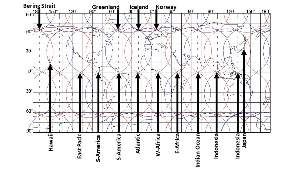
The points selected here with arrow all need special attention. How did the Bering Strait open up? How does the volcanic activity of Hawaii work? The answer is that Hawaii is located over the division line of two large scale convection rolls. The East Pacific main ridge is close to the point pointed out with the arrow here, but there is a smaller ‘side ridge’ at the division point between large scale convection rolls. The west coast of S-America is a prominent point, with a huge trench. Then the Amazon delta is also one of the most decisive equatorial points of the convection rolls system of the Earth. The long stretch of Mid-Atlantic Ridge along equator has of course a point at the center of the ocean, pointed out here. Then, 30° farther eastwards is the west coast of Africa. Going 30° to the east from there, you will see the Great Rift Valley of Africa. Another 30° to the east, the Mid-Ocean Ridge of the Indian Ocean is found exactly where it should be according to this model. Going farther, namely 30° to the east, the west coast of Indonesia provides the base for the next point. Travelling 30° over Indonesia, you will reach the eastern coast. To explore the next division line between convection rolls, it is best to see Japan, actually Mt. Fuji, the most famous volcano of Japan. To further convince oneself of the sensibility of this system, we should have a look at Greenland, Iceland and Norway, providing a pattern over the North Atlantic. The model of the world is so inaccurate that the details cannot be detected, but luckily, I have worked them out also. It is always possible to ‘zoom in’ on each location to analyze in detail what really happens there, when doing so, the interaction between different layers of the mantle can be considered, and you will feel everything starts making more and more sense.
Because how obvious this is, everyone can accept the idea that large scale convection rolls shape the world. As can be seen in other posts, there are countless examples of the tiny details which can be explained with this model.
