A large river of North Iceland shows resemblance with the forces underneath. It finds its way directly to the north by swaying to the polygons east of the central axis of the North Volcanic Zone. The small polygons there are under pressure from the central polygons of the volcanic zone, thereby breaking up diagonally from north to south, providing tectonic lines for the river to follow.
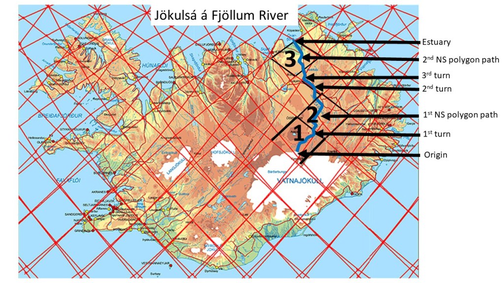
Jökulsá á Fjöllum River.
Three polygons are marked on the map, namely those with inner tectonic structure for the river to flow afert. The first is still affected by the East Volcanic Zone, with tensional forces leading the river to the NE. At the boundary of the next polygon, the river is already east of the central axis, and the polygon must therefore be subject to some pressure and rotation, breaking it diagonally NS. The river flows to the 2nd turn where it starts following the border between two polygons. At the western corner of that polygon, it enters the realm of the third polygon, being the northernmost of the North Volcanic Zone series, it has a trend for providing NS tectonic features, leading the river accurately to the northernmost corner, where the estuary is found.
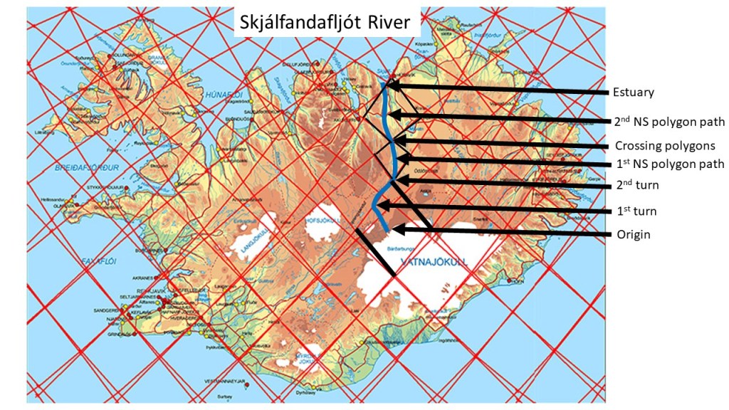
The path of Skjálfandafljót can be traced according to the tectonics related to magma flow. First, the direction of each section follows the tensional matrix, or pressure induced on the primarily diamond-shaped polygons as shown here.
Skjálfandafljót River.
The origin follows an NW aligned path, until it reaches the border of the polygon, then it turns towards NE along the division line. At the northern end of the polygon, the river turns northwards, and crosses the northern corner of the other small polygon as well (1st NS polygon path), repeating the same story within the next polygon (2nd NS polygon path) until it reaches the estuary.
The name, Skjálfandafljót, refers to the Skjálfandi Bay, literally meaning Trembling Bay due to frequent earthquakes in the area. The tectonical activity level probably contributes to the clear features of this particular river alignment.
The North Volcanic Zone of Iceland is clearly aligned from north to south. But Iceland has another axis like that, farther to the west. The two different axis or lines are of the same nature. Actually, the North Volcanic Zone did replace the Skagafjordur Volcanic Zone. Therefore, the distance between the two axis is exactly 3° from east to west, because both axis have their roots in the convection rolls pattern.
The two NS-axis of Iceland – old and new
The western axis is older, and contains the central polygon of the Icelandic Plateau, where the distance to the edge of the elliptically shaped plateau is the same to the east and west. As shown in other posts, that axis is also centrally located between the main outposts of Icelandic volcanoes, Snæfellsjökull and Snæfell.
We get a geological/geographical bonus by seeing how the glacier Vatnajökull is shaped by the convection rolls framework, as one polygon is colored almost completely white. The other parts of the glacier seem to reach out from that central area. Similar features can also be clearly found for Langjökull, covering the western half of its polygon.
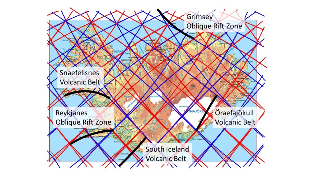
Usually, we mention the large volcanic rift zones extending over central Iceland. But the small volcanic zones deserve attention as well. According to this model, they have one thing in common, that is they extend over a pair of convection rolls. Here, the zones and belts are marked centrally with a black line.
The smaller volcanic zones and belts of Iceland.
Grímsey Oblique Rift Zone is least known and hardly mentioned in overview material about the geology of Iceland. It connects the North Volcanic Zone with the Kolbeinsey Ridge. It has a similar function as Reykjanes Oblique Rift Zone, providing a connection with the Reykjanes Ridge. Apart from those two systems, there are three other marginal systems. First is Snaefellsnes Volcanic Belt, found in the West of Iceland and it seems to be hard to explain why it exists at all. In the East, Öraefajökull Volcanic Belt is also hard to explain, although it is usually said that it represents a new development as volcanic activity gradually moves eastwards. Finally, the South Iceland Volcanic Belt is not always regarded as an independent area, as it connects directly with the East Volcanic Zone.
All those zones and belts should be analyzed according to the effect of the relevant pair of convection rolls and how coupling between layers will affect their development. One more volcanic zone could be mentioned in this context, that of Hofsjökull. It is small and behaves in a different way than the West, East and North Volcanic Zones.
The NW of Iceland has the same shape as the North and East. Do yo believe that? Of course not! All right then. Some things have to be explained step by step.
The geologically oldest parts of Iceland. Map fromIcelandic Institute of Natural History.
First, I point out three different parts of consideration. I will compare the northern and eastern parts, with the NW part.
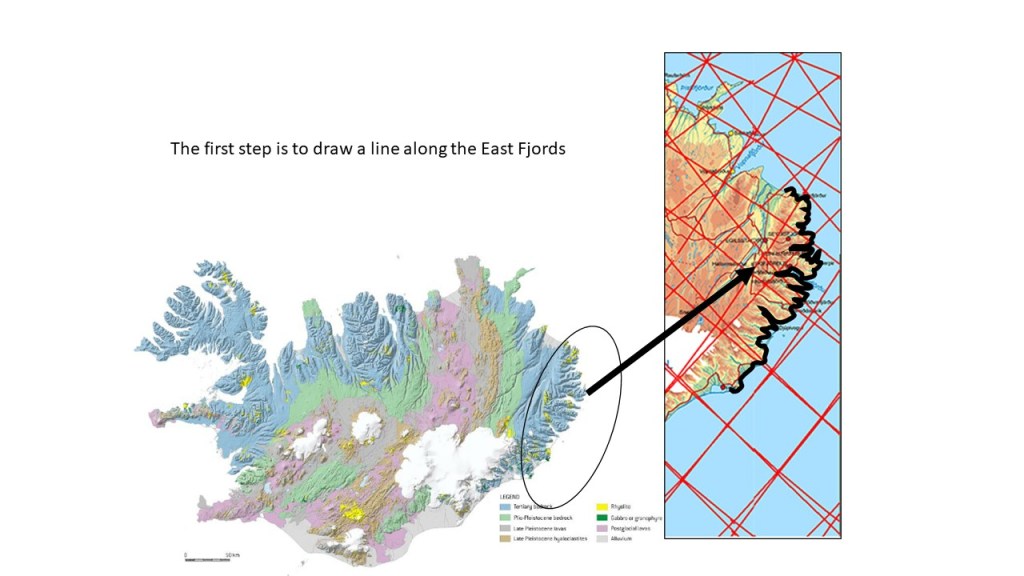
A line drawn along the East coast of Iceland.
The East is a rather distinct area, characterized by fjords, surrounded with mountains. Once having the line drawn, we can duplicate it and past it on the NW peninsula.
The East coast of Iceland compared with the East coast of the NW peninsula
This is an interesting story. This ‘fit’ is not easy to get, it follows the curvature of the entire coastline and quite a lot of details enhance the match. Besides that, turning anti-clockwise 45° is not that random. These areas are often compared, because they have similar age geologically. Some might say that the line is thick, so it hides the differences. I anticipate that, and to be able to continue with the story, a map with a thin line is added. Sure, there are tiny differences, so tiny that they have to be searched out with some difficulty. So I have to find someone who wants to say: ‘During 10 million years, the factors shaping these two sides of the country should have formed the areas differently’. I totally agree, but the word should is not that scientific. I have facts here to deal with. So I keep on with the story with a big smile, just like no one ever thought of interrupting me 🙂
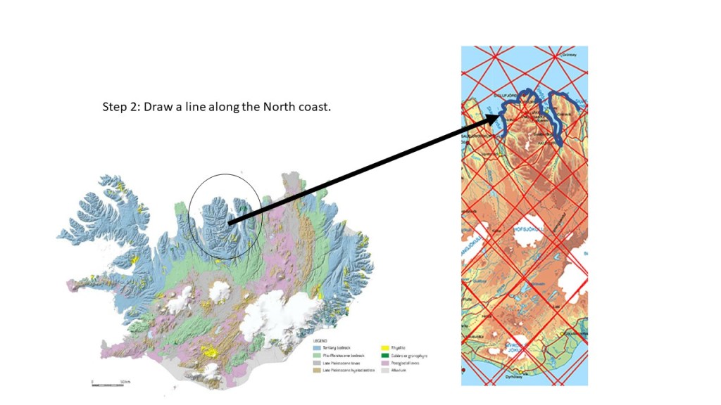
The North coast of Iceland marked with a line.
Now another geologically old part of Iceland is examined. We draw a line along the coast of the central North. The main peninsula is called Tröllaskagi (The Troll Peninsula), because of its rugged appearence. The Eyjafjörður area is also included, as it the bedrock there is of similar age.
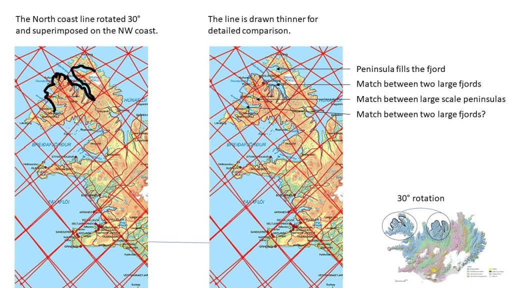
The North compared with the NW peninsula.
Now the line along the North is copied and rotated anti-clockwise 30°. It fits amazingly well with the NW coast of the NW peninsula. Why is that? Again, a thinner line is used for detailed comparison. The northernmost part has a larger small peninsula, but generally the topography is shaped in similar way. The large scale fjords of Eyjafjörður and Ísafjarðardjúp fit surprisingly together. After that, the central peninsula of the large scale NW peninsula fit with the Tröllaskagi shape. The comparison ends with Skagafjörður and Arnarfjörður, because Skagafjörður was enlarged about 2-3 million years ago when a rift zone developed within it. It can therefore hardly be compared with its counterpart of the NW, Arnarfjörður, which has never underwent any rifting process.
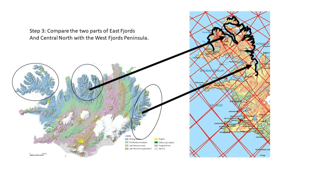
The three areas of NW, N and E, compared.
As this blog has a bit longer text than usually, a wider comparison is made here at the end. The two areas of N and E have now been added to the NW peninsula. What do we then have? Actually, a superimposed drawing of the whole peninslula is emerging, like it has been duplicated! I can tell you why. These areas have emerged in the same way as the NW peninsula, and then drifted away from the volcanic zones to the present locations. Therefore, they have similar edges, with similar weaknesses, taking on similar forms when the glacier and ocean shape them through millions of years. As tectonic drift is not that random, subject to the regular forces of magma flow, the angular difference becomes regular as well. Rotation of 30° and 45° respectively, making a match, is far beyond any chances of coincidence.
So here we end this story of this long blog post about magic magma. There is much more to tell, as we ended the comparison mentioning the Skagafjörður Rift Zone, altering the north coast of Iceland. There is also a ‘tiny’ piece of old rock in the middle of the West of Iceland (Borgarfjörður). Does that one also match with a part of the NW peninslula? There are so many questions to ask about this subject. So, please relax. These were just a few facts pointed out to everyone, put into the form of a story, so you are not required to either believe or deny anything 🙂