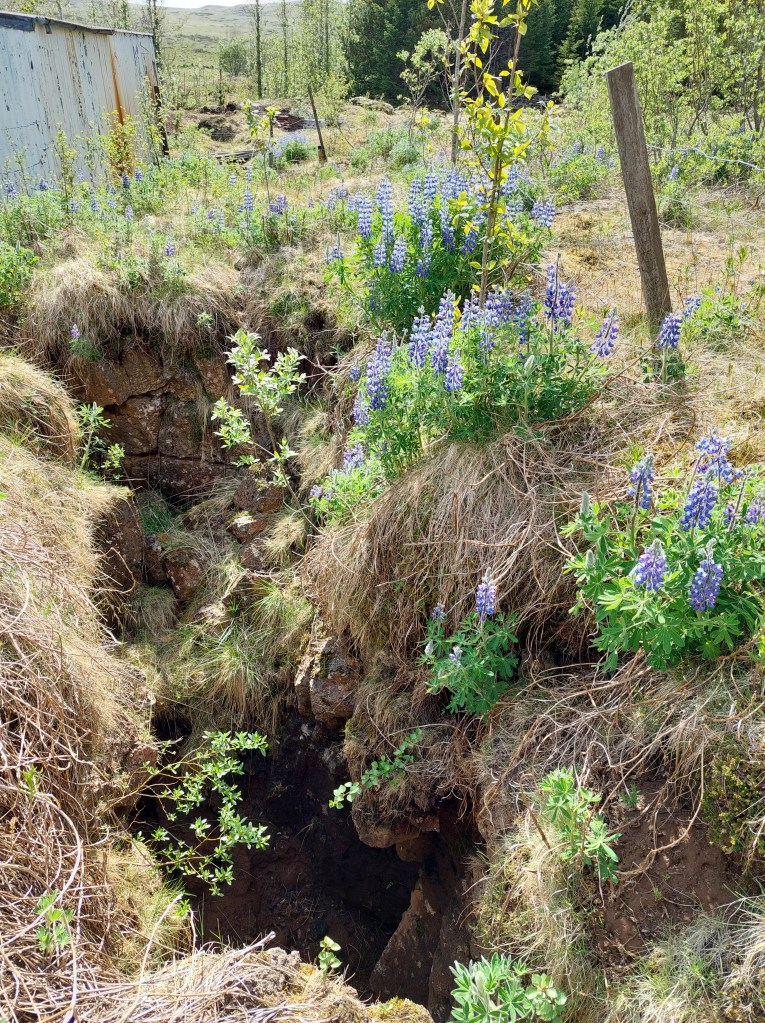
This crack was measured to be 10 meters deep shortly after the large earthquake of Southern Lowlands in Iceland, June 21 in the year 2000, measured to be 6.6 on Richter scale.
The earthquake fault of June 21 2000.
The picture is taken just south of road number 1, towards the shouth. The fault is right-lateral, so if you would have stood at the side of the moving fault, the other side would have been seen to move to the right hand side.
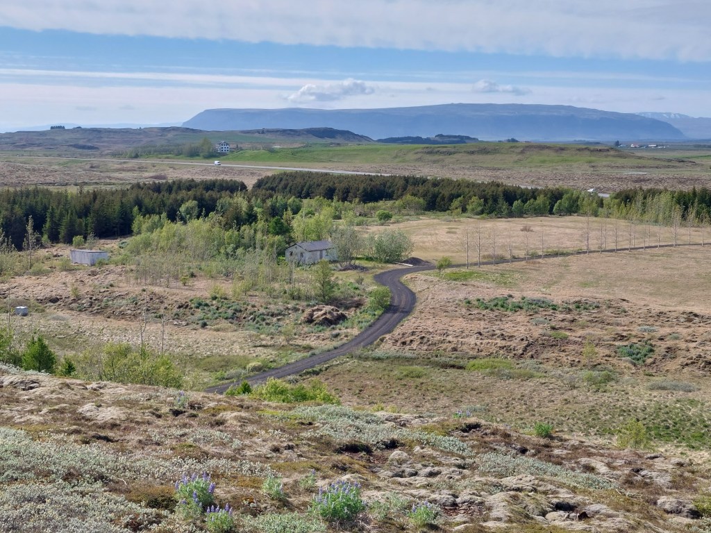
The fault area (the crack extends between the small houses), and Ingólfsfjall in the background.
The side of Ingólfsfjall seen above is actually marked by an earthquake fault, oriented directly N-S. This is just south of 64°N, the central latitude of the South Iceland Seismic Zone. The faults themselves are all parallel, with the average distance of 715 meters in between them.
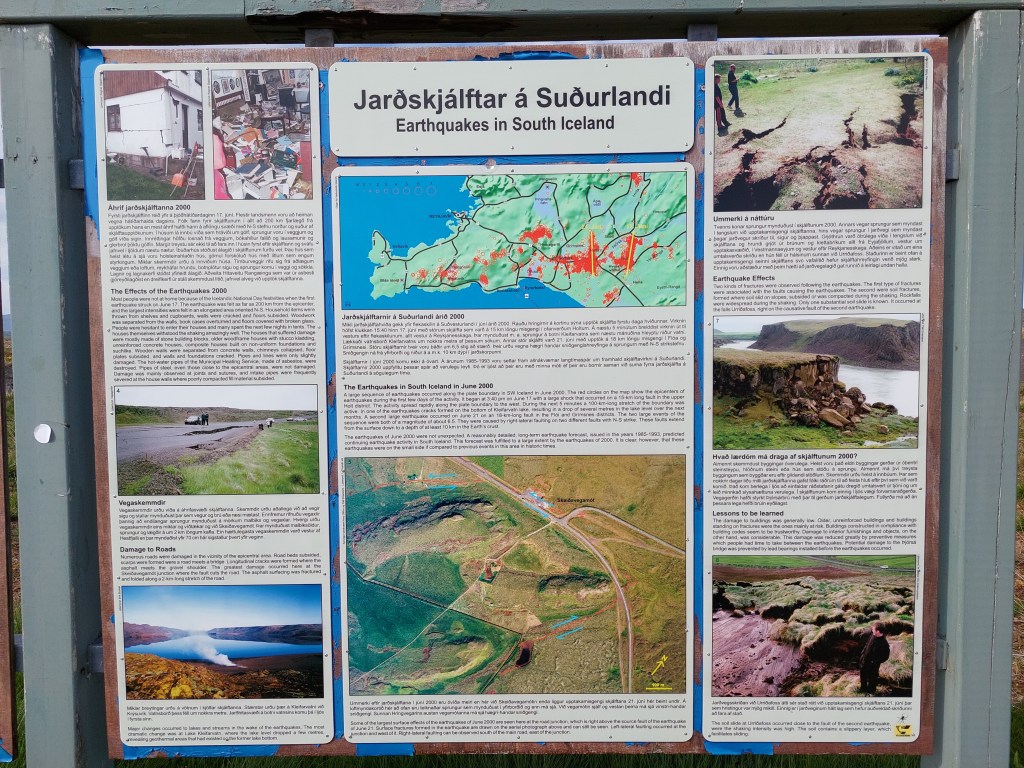
Explanation sign at the crossroads where the earthquake occurred.
The South Iceland Seismic Zone reveals the convection rolls, because it extends exactly over one roll from west to east, that is from the town Hveragerði to Hekla Volcano.
Perhaps some people have noticed that Italy and New Zealand have the same latitude, in the north and south hemisphere though. The center of the countries is found at 42°N and 42°S, respectively. It is not a joke, but a fact, that the shapes of both countries resemble a shoe, and the distance from 42° to the heel of the two shoes is the same. Then I can tell you a joke: I have found those two countries to be a geological pair of shoes! Those shoes are namely approximately identical, just as should be expected from a single pair. The comparison can be further extended by the fact that those two shoes of one pair are the mirror image of each other. Therefore, I present the mirror image of New Zealand for everyone to appreciate how similar the shapes of those countries really are. It would probably not sound so interesting if it was the only similarity, but as mentioned before, the central points are at the same latitude N and S, and the proportions as measured from there are the same. Both countries have volcanoes close to the ‘toe’, in a mirrored way though. Moreover, the two countries are aligned similarly, but again, you have to remember that they are mirrored, so the aligment effect of North Italy applies to the opposite end of the shoe shape of New Zealand. OK, if you do not follow me any more, please remember it can hard to understand geology jokes.
The world geology pair of shoes – Italy and New Zealand
The alignment of both countries follow the formula α = (arc tan {[(35.342 – (ϕ – 32)2) 0.5 / (ϕ – 32)](1/cos ϕ)})/2 where α is found in the mathematical way as compared with x-axis, that is latitudinal axis. It is thereby found to be approximately E39°N at the latitude ϕ=42°N for Italy. Then we can calculate the mirrored result for New Zealand, being W39°S at the latitude ϕ=42°S 🙂 Then you can calculate the value for other latitudes.
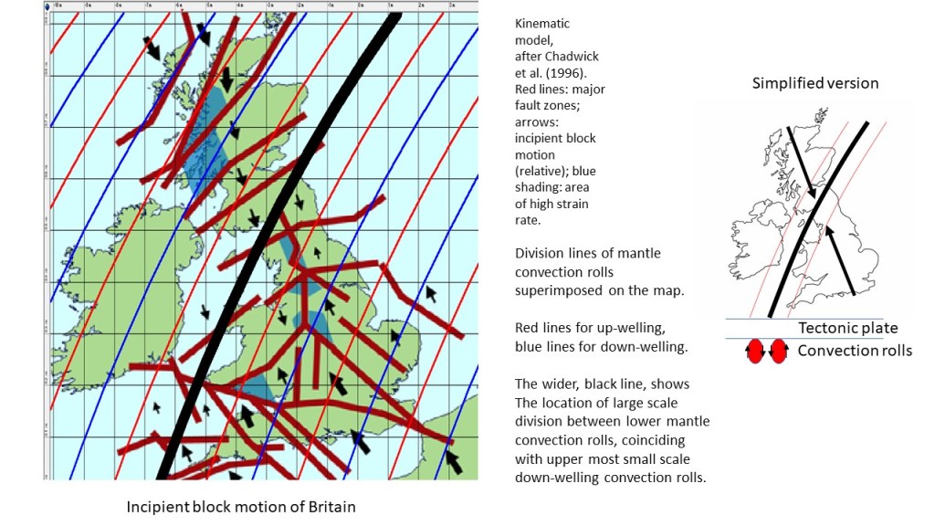
Comparing model with real measurements is essential, and it will eventually lead to better understanding of the forces behind the data we accumulate. The incipient block motion of Britain clearly converges around the line indicating main division deep underneath between two large-scale convection rolls, each spanning 30° from east to west. The upper more convection rolls do also play a role, of course, each spanning 1.5° from east to west. This drawing should explain it all:
Kinematic model of Britain with convection division lines superimposed.
Some details can also be added if the lower layer of small scale convection rolls is added.
Kinecatic model compared with convection rolls model.
Tectonic features in the north follow division lines quite closely, and high strain area (blue) in Scotland shows clear resemblance with the polygons of the convection rolls system. The arrows are more and less perpendicular to the upper more convection rolls, as might be expected.
Large scale features of the Earth can be represented with mathematics. The western side of the East European Craton is associated with the zone, and it can be clearly defined seismically, as shown here: https://www.sciencedirect.com/science/article/pii/S1611586419300034.
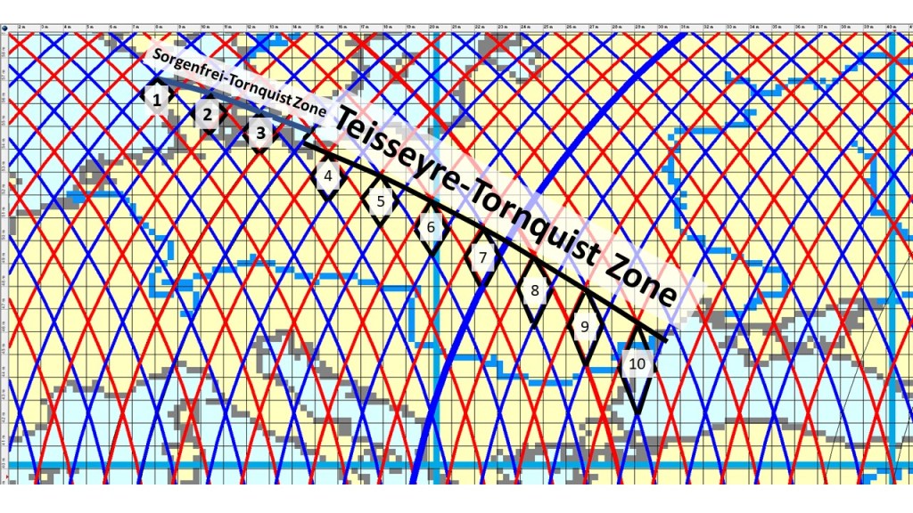
The mathematics of the convection rolls system fit to the alignment of the Teisseyre-Tornquist Zone and its Danish counterpart Sorgenfrei-Tornquist Zone. The seismicity follows the pattern of polygons very accurately, as shown here by numbering the adjacent polygons. When the alignment follows 10 polygons in exactly the same way, the accuracy and regularity indicates that the line of seismic activity is indeed affected by this pattern.
Teisseyre-Tornquist Zone and Sorgenfrei-Tornquist Zone compared with mathematical grid.
This is a main feature of Europe’s geology, and it coincides with the estuary of the Danube river into the Black Sea.
The shift from Sorgenfrei-Tornquist Zone to Teisseyr-Tornquist Zone also fits mathematically to the pattern of convection rolls, as shown here.
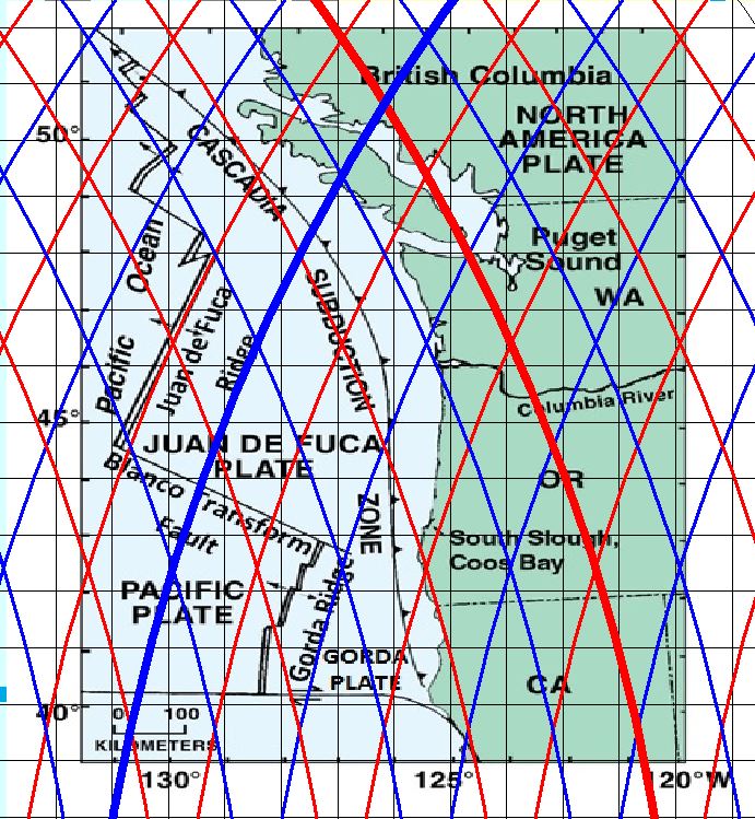
It is easy to detect the resemblance, and analysing the geophysical proberties becomes much like reading a book. The ridge of Juan de Fuca extends along a red division line (up-welling) for a distance resembling two polygons, marked by the convection rolls below.
The Gorda Ridge is of slightly different nature, because it is not found on a division line, but between them. It means that the area between the relevant divsion lines is being pulled by the main tectonic drift, resulting in the tension creating the ridge. Similar difference between features located directly above division lines (Reykjanes Ridge) and those occupying the areas above a single convection roll (East Volcanic Zone of Iceland) are aligned along the convection rolls system.
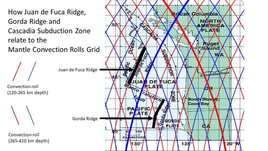
For a second look, this drawing, based on the same map as above, can be added:
Juan de Fuca system.
There are many details to be noticed, even though this map is not nearly as accurate as could be provided. The Blanco Transform Fault extends between two points where division lines cross each other, because those are points of weakness in the deep tectonic framework. The Gorda Ridge bends at the border line between polygons, as the stress field changes there. The Cascadia Subduction Zone bends back and forth along a lower convection rolls division line. As most people have not yet learned about the convection rolls system, and its implications, it is good to check the present state of knowledge regarding Juan de Fuca plate and its development on the Wikipedia site: https://en.wikipedia.org/wiki/Juan_de_Fuca_Plate.