Uncategorized

Special conditions – NS alignment of convection cells at 32°N and 32°S

The convection rolls shall be oriented exactly NS at 32°N and 32°S. Is there any indication for this? Let us have a quick look. What about these two locations:

S-America NS at 32S

This surely can not be closer to NS.

Japan NS at 32N

Neither can this.

This means we can find very prominent features at 32°N and 32°S aligned NS, the same way as the convection rolls underneath.

Can we find something more special at the 32nd latitudes?

Uncategorized

Convection within the Earth’s mantle

Knowing that the distance from the outer part of Earth’s core to the top of the Gutenberg layer is the same as the diameter of the core, you can tell that convection within that space is virtually circular. It is one of those ideas becoming clear in a fraction of a second. After that we just need to work through the details to find out new things about Earth.

It is logical that convection that has been going on for billions of years has identical height and breadth. By adhering throughout to the same principle of identical height and breadth of convection rolls within every layer, and then a perfect horizontal path shaped by the Coriolis Effect, the interior of the Earth had been mapped.

Therefore it is possible to provide endless examples about wonders of the world.

It is easy to learn step by step. Step 1: In the upper most 120 km of the Earth, no convection takes place. The brittle layer of continents is thick, while the brittle layer of oceans is thinner. The ductile layer below works as a buffer, always adjusting the total thickness of a tectonic plate to 120 km.

So let us have a look at a drawing:

Tectonic plate

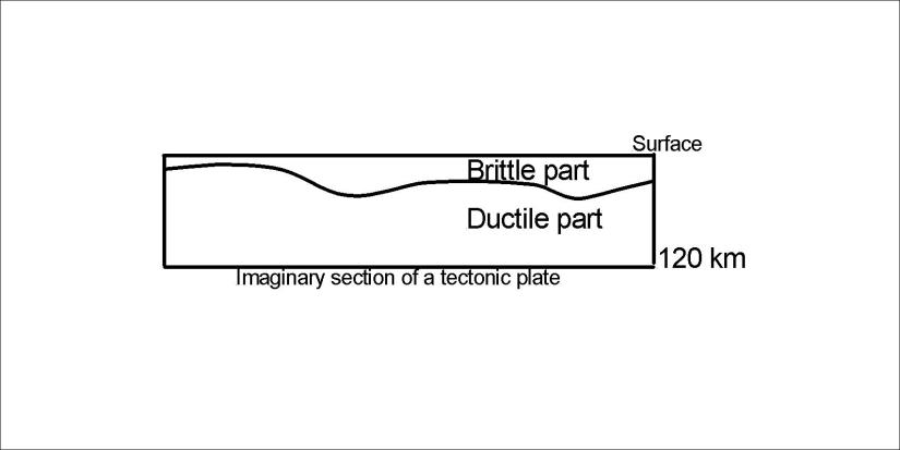
All the Eart’s surface is of that total thickness. The division line between brittle and ductile part is called the Moho discontinuity. The 120 km discontinuity divides the tectonic plates from the convective under-layer.

Step 2: Looking a bit further down it looks like this, with the two upper most layers of convection:

Tectonic plate and convection rolls

Step 3: Learn how these rolls extend over the whole Earth!

Step 4: Realize what the regular pattern of mantle convection rolls looks like 🙂

These rolls can be compered with the upper and lower currents of the ocean, and the upper and lower part of the troposphere of our atmosphere. Therefore it was possible to derive the exact shape and position of these rolls.


Uncategorized

The symmetry of S-America and Indonesia

The large convection cells within the Earth according to analysis of a model where rolls are formed with identical height and breadth. S-America and Indonesia are ‘mirrored’:

Equator Plane with S-America and Indonesia

This amazing fact can be elaborated on in countless ways. Let us compare two points:

S-America and Indonesia - similarity - lines - 01

These pictures show how the coasts of S-America and Papua follow the same trend. The trend can be calculated as for horizontal forces at 0° latitude, about 12.5° compared with EW-axis. As the red arrow show, identical tectonic features appear exactly the same distance away from the division point of convection rolls at equator, marked with yellow position pin of Google map inside the red circles.

Uncategorized

The lakes of Finland

conifer daylight environment evergreen
Photo by eberhard grossgasteiger on Pexels.com

Finland is a country of lakes. The glacier of the ice age did dig out these sites of peaceful surroundings. One can easily find a certain direction many of the lakes follow. Calculating according to Coriolis Effect the path of mantle convection rolls fits exactly to this alignment. This can be shown on the base of a Google map:

Finnland - 01

It is just amazing how accurately these calculations fit for tectonics and topography.

This can be calculated because the convection rolls sway according to the difference of rotation speed of the Earth from one latitude to another in a perfectly regular way. This is the same effect as governs the path of wind and sea currents. The mantle under Finland has made way for the glacier in harmony with the alignment of convection rolls.

holidays car travel adventure
Photo by Mihis Alex on Pexels.com
Uncategorized

Earth and Mars – can they be compared?

The largest shield volcanoes on Earth and Mars are exactly on the same latitude (18.6°N). Mauna Loa, Loihi and other volcanoes of Hawaii and the huge Olympus on Mars are found there. Let us compare the planets accordingly:

Earth and Mars (Hawaii and Olympus)

I got this map of Mars from http://mapgame.wikia.com/wiki/File:Mars_map.jpg

Of course this is an indication that Earth and Mars have hot spots formed in an identical way. Planets should have a tendency to form the same kind of convection rolls system.

This comparison fits also quite clearly for Ascraeus Mons, another shield volcano on the next convection rolls division line east of Olympus. Anyway, someone familiar with geology on the planet Mars could make this comparison.

white space ship and brown planet
Photo by SpaceX on Pexels.com

If the convection cells systems for Earth and Mars are identical, the grid lines of longitude for Mars have been shifted about 22° to the east, as can be seen on the picture above.

To keep our feet on the ground, here is a picture from Hawaii. This also happened on Mars billions of years ago.

erupting lava during daytime
Photo by Pixabay on Pexels.com