I am a geologist, graduated from the University of Iceland, and taught geology for a few years. I have gained some knowledge about Earth's inner structure, so I provide this website as my contribution to answer one of the greatest questions remaining within the realm of geoscience. Experiments show that the mantle should form convection rolls when close to the melting point. I took this literally, and calculated the dimensions and shape of these mantle convection rolls. Then I compare that model with the surface. This makes it possible to provide many interesting examples about geology found on my blog.
One of the famous hot springs where people can take a bath is at Landmannalaugar. It is found in the middle of a polygon, with Hekla and Laki at each side.
The central position of Landmannalaugar within a polygon
Landmannalaugar are found at 64°N, the same parallel as Hekla and Laki. The latitude is also the central axis of the SISZ, extending from Hveragerði to Hekla. Repeatedly, we can trace the NS and EW-axis of different polygons. The ductile part of the tectonic plate, reaching 120 km down where convection of mantle starts to take place, gives way to the tectonic drift and breaks along the middle axis from one corner of the polygon to the other. Therefore this is repeatedly seen on the surface.
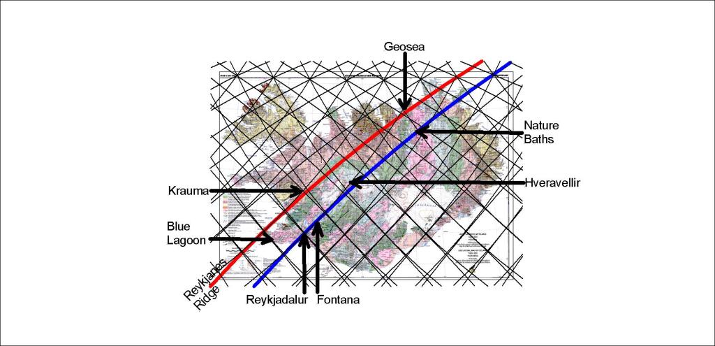
The Reykjanes Ridge can be extended over Iceland (red line), explaining the location of several geothermal spa sites in Iceland.
The geothermal baths in Iceland found along the main division lines of mantle convection rolls
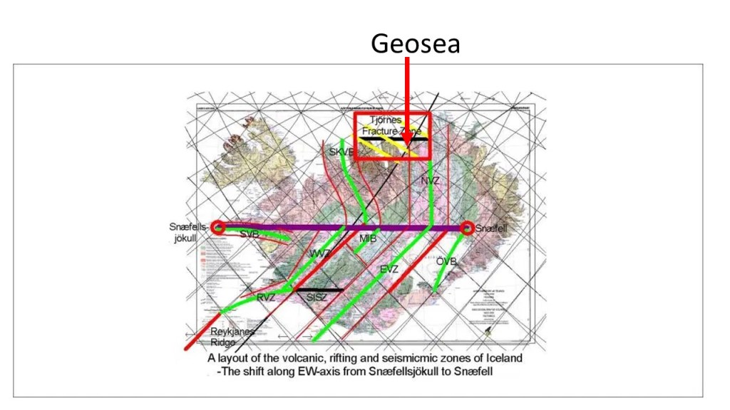
The red line shows the Reykjanes Ridge and how the two relevant convection rolls extend over iceland. Over the division line, or close to it, the Blue Lagoon at Svartsengi, Krauma of Deildartunga, and Geosea of Skjálfandi Bay, near Húsavík are found.
The blue line is actually the main division line of the two large convection rolls in lower mantle, but the upper most small convection rolls converge against each other. The division line marks the eastern edge of the West Volcanic Zone, where Fontana at Laugarvatn is located, and Nature Baths of Mývatn. It is also close to the Geysir area and Hveravellir in the center of Iceland. The Reykjadalur geothermal river has many bathing sites, near Hveragerði, which is of course on the blue line. Therefore, some additional points could be added with explanations according to the mantle currents pattern underneath. It is not necessary, though, because this shows the main pattern.
This shows the resemblance between convection rolls of the mantle and the main geothermal spa areas in Iceland.
Here is a list of web sites for those spa sites.
Krauma – at Deildartunga in Borgarfjörður area, West Iceland:
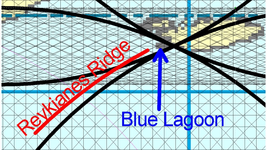
The Blue Lagoon in Iceland is close to the Reykjanes Ridge which divides the Eurasian tectonic plate from the North American tectonic plate. Shown in context with the mantle currents, the exact location is on the top of a perpendicular division line.
Blue Lagoon location
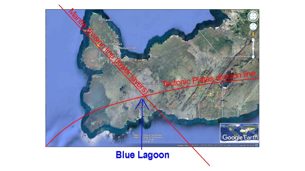
Besides this, the Reykjanes Ridge actually ends close tho the Reykjanes Peninsula, and a volcanic zone replaces its role as a divisional feature between the tectonic plates. The Blue Lagoon is found within that volcanic zone, explaining the location further. Zooming in and adding the tectonic division line shows how accurate the crossings fit with the location of the Blue Lagoon:
Blue Lagoon at the crossings of tectonic and mantle division lines
The tectonic featueres consist mainly of NE trending volcanic fissures and N-S oriented earthquake faults, but NW trending topography might also be found. Detailed material and maps can be found at this site:
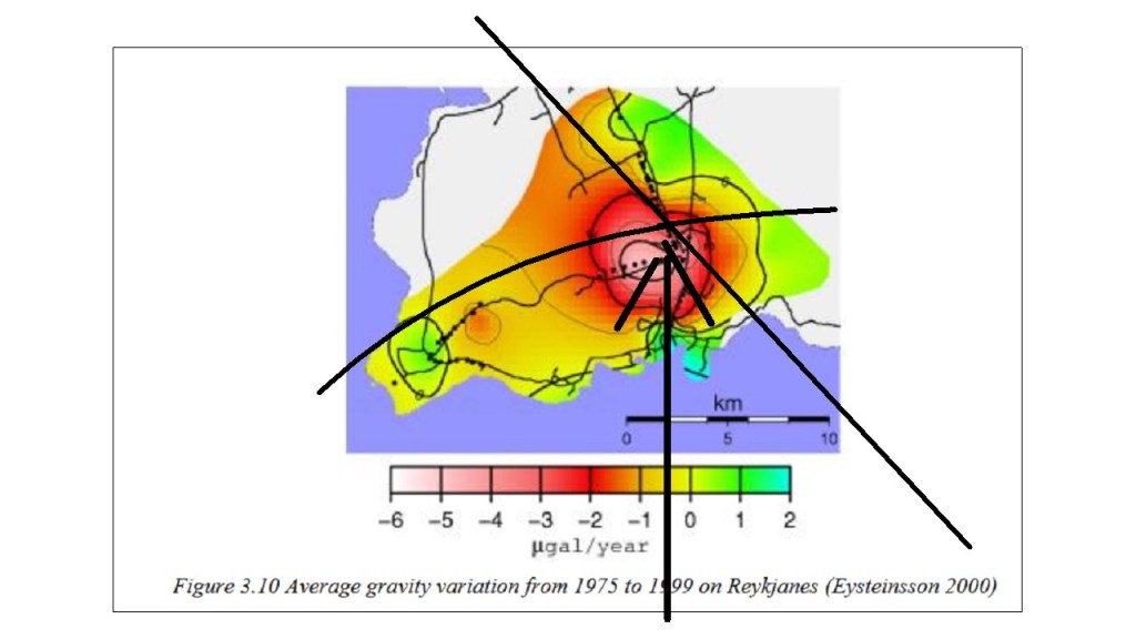
An indication that the NW-SE oriented mantle division line, underneath the convection rolls oriented NE-SW shaping the Reykjanes Ridge, have direct effect on the area is this map showing the changes of gravity as measured from 1975 to 1999:
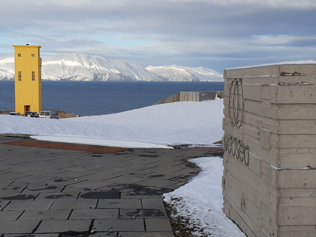
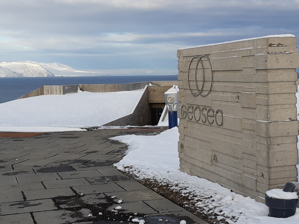
Geosea near Húsavík in Iceland is a new tourist attraction. The baths make use of geothermal heat in the area, originating from boreholes at the seaside.
Geosea and the lighthouseThe entrance of GeoseaThe position of Geosea, on the division line
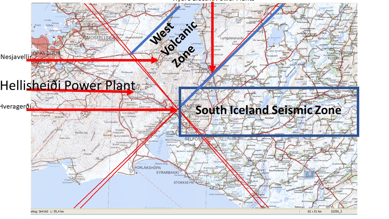
The Hellisheiði Power Plant is found on the list of top ten geothermal power plants in the world. As a single power plant producing about 300 MW of electricity and with the equivalent of 133 MW for supplying hot water, it provides a total of over 400 MW of energy.
The location of Hellisheidi Power Plant is in accordance with the convection currents of Earth’s mantle, as shown on this map:
The location of Hellisheidi Power Plant
These lines are derived from the section of convection rolls found at equator.
The equator plane section of measured layers, with convection rolls pattern inserted.
By deriving the division lines to the north from equator, they can be traced towards Iceland. The main division line between two of the twelve large convection rolls of lower mantle is found under the power plant, providing the energy and geological preconditions for utilization of geotherrmal heat.
Where the Power Plant is located, the two plates of Europe and America meet. But underneath the two mantle convection rolls under the eastern and western side of the Atlantic Ocean pull in opposite directions, excerting the force necessary for the tectonic drift to occur.
Let us have a closer look (zoom in) at the crossings, pointed out on the large scale map above:
The location of Hellisheiði Power Plant compared with crossings of main division lines of convection rolls
The town of Hveragerði has the most spectacular location, as the main crossings are found at the montain Reykjafell at its side. Only just over 10 km away is the Hellisheidi Power Plant. Another power plant of Nesjavellir is nearby. In between them is the volcano Hengill, with the division line under it, with the orientation of NW-SE. In this way, we can look into the details of the main crossings of convection rolls in Iceland, providing a set of very special geological phenomena.