Uncategorized

The Geometry of the Greenland–Iceland–Faroe Ridge Complex

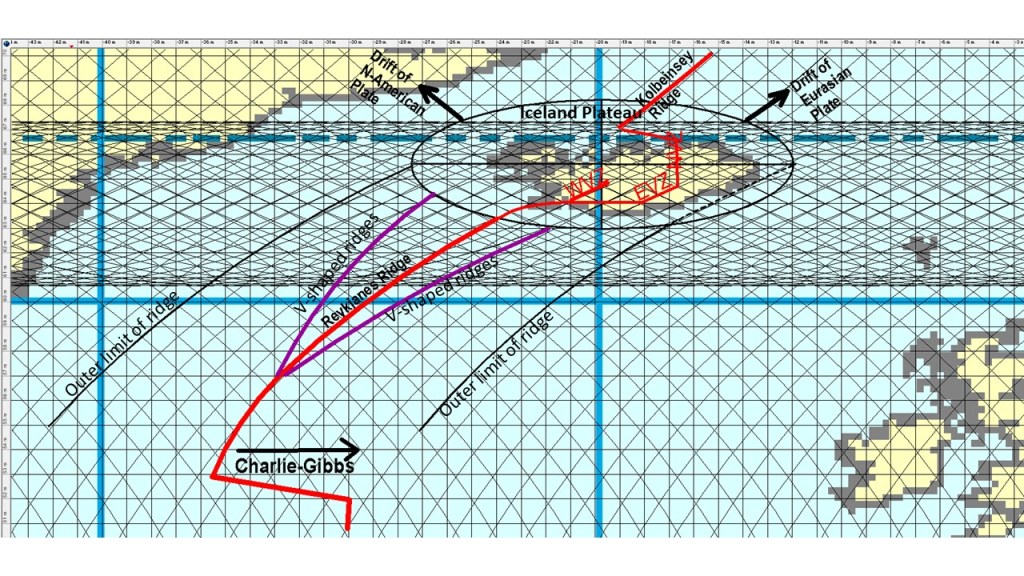
The ridges connecting the Icelandic Plateau with Greenland and the Faroe Islands are equidistant from a single point in central Iceland. This can be seen in the map below:

The equidistant points of the Greenland–Iceland Ridge (GIR) and the Iceland–Faroe Ridge (IFR) compared with central Iceland

The basic map is from https://sp.lyellcollection.org/content/447/1/127/tab-figures-data

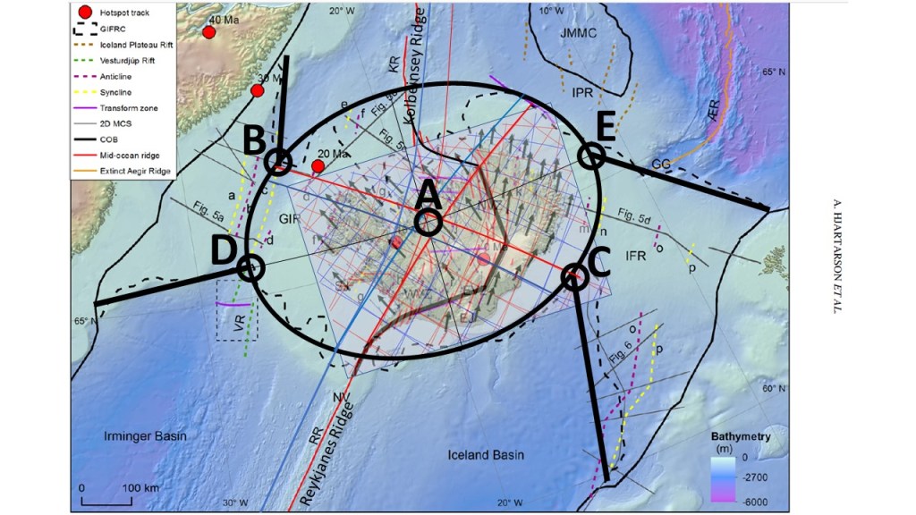
On the base map, the elliptical outline of the Icelandic Plateau has been added, with its central point marked as A. The locations where the Greenland–Iceland Ridge and the Iceland–Faroe Ridge meet the ellipse are marked as B and C; both lie at equal distances from point A. Similarly, points D and E, defined along the ellipse, are also equidistant from A.

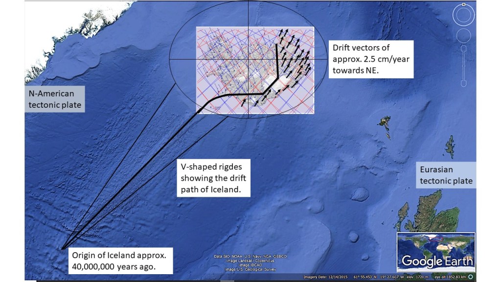
When the bathymetric extensions of the Reykjanes Ridge and the Kolbeinsey Ridge are traced, they also converge toward point A. Thus, if we normalize the surrounding topography relative to the elliptical form, all of these ridge systems ultimately meet at a single focal point: A.

It is notable that points D and E lie on the same latitude, while B and C fall along the same meridional division, reinforcing the symmetry of the structure.

The Icelandic abyss appears to have developed gradually into a remarkably precise elliptical form. This ellipse is oriented exactly east–west, with its major axis defining the long dimension of the Icelandic Plateau.

When the outline of the ellipse is compared with surrounding ridge systems, the symmetry is striking. The Greenland–Iceland Ridge and the Iceland–Faroe Ridge both coincide with the ends of the major axis. The other two margins align with features that reflect mirrored convection rolls relative to those of the Reykjanes Ridge. In other words, the abyssal form not only echoes the geometry of the connecting ridges but also mirrors the mantle dynamics that created them.

Eliminating the strong bathymetric influence of the Reykjanes Ridge and the Kolbeinsey Ridge, the elliptical outline becomes nearly perfect. Yet this geometric precision has largely gone unnoticed, perhaps because attention has traditionally been focused on local volcanic and tectonic features rather than the broader structural form of the abyss.

The symmetry becomes even more compelling when viewed along the central meridional division through point A, the ellipse’s geometric center. This line passes directly through the craters of Hekla and Eyjafjallajökull — arguably Iceland’s two most famous volcanoes. Moreover, if the axes of the Reykjanes Ridge and the Kolbeinsey Ridge are extrapolated inland from the seafloor, both converge at point A as well.

Such a degree of geometric and geodynamic coincidence is unlikely to be accidental. It suggests that the Icelandic abyss represents not only a surface plateau but also the expression of deeper, organized mantle flow. Explaining why this elliptical form has persisted — and why it has been overlooked — remains an important challenge for understanding Iceland’s unique geodynamic setting.

Uncategorized

The Connection between Iceland and Charlie-Gibbs Fracture Zone

It would be hard to understand the formation of the Reykjanes Ridge and Iceland without Charlie Gibbs Fracture Zone. The shift of location of the central axis of the Ridge along Charlie-Gibbs is in fact exactly half the width of the Mid-Atlantic Ridge. Thereby we have a reason why the drift vectors appear to be along the eastern side of the Reykjanes Ridge, not away from it.

Charlie-Gibbs Fracture Zone and Iceland
Uncategorized

The Consistency between Reykjanes Ridge, V-shaped Ridges and the Icelandic Elliptical Plateau

Iceland is a part of a large geological structure, consisting of the Reykjanes Ridge and the bathymetric Elliptical Plateau of Iceland. In turn, Reykjanes Ridge is marked by V-shaped ridges. We can try to look closer at the context:

The Icelandic Elliptical Plateau in context with Reykjanes Ridge and V-shaped ridges

The V-shaped ridges converge at the point where the alignment changes to north-south. This brings us closer to the exact consistency between the convection rolls and the Icelandic Elliptical Plateau, with a NS-axis through Eyjafjallajökull, Hekla and Hveravellir, along with the (volcanically extinct but still seismically active) Skagafjördur Volcanc Belt, which is connected with the Kolbeinsey Ridge north of Iceland.

A map from the Icelandic Land Survey is superimposed on the Google Map, and some of the measured drift vectors shown with black arrows. These vectors show the current tectonic drift directions of Iceland. The country is mainly drifting northwards, but being divided at the same time to the NW and NE. This is more complex than the old version of saying that the two halfs of Iceland should be drifting opposite to the other to the west and east. The true description of tectonic drift of Iceland is more complicated than that.

Uncategorized

The Origin of Iceland

The origin of Iceland can be traced according to recent measurements. Following the drift vectors of the Eurasian Tectonic Plate backwards, we find the exact point.

The V-shaped ridges representing the drift path of Iceland.

The drift vectors can be measured in the eastern half of Iceland with GPS technology. The report is published here: https://www.lmi.is/static/files/utgefid_efni/Maelingar/isnet_endurmael_2016_skyrsla.pdf

The V-shaped ridges are in fact not perfectly symmetrical around the Reykjanes Ridge Central Axis, because the N-American Tectonic Plate drifts perpendicularly to the ridge. Symmetry is found around the North Volcanic Zone of Iceland, though, because it is aligned directly from north to south.

For clarification, I also include the map fram the National Land Survey of Iceland, along with the relevant text:

Tectonic drift of the Eurasian Tectonic Plate. Darker drift vectors superimposed in the Eurasian half of Iceland.

This might seem contrary to what is shown on most geology maps, showing the drift vectors of the Eurasian Plate towards the east, or slightly south of east. It is simply because most geoscientists choose to omit the northern drift component, emphasizing on the divergent effect of the tectonic drift.

The V-shaped ridges have been found to be the result of propagating anomaly along the Reykjanes Ridge. A good article is found here: https://agupubs.onlinelibrary.wiley.com/doi/10.1029/2002GC000361

The variations in melt production rate at the Mid‐Atlantic Ridge (Reykjanes Ridge) extend to the point where Iceland started to form, and the southern more Charlie Gibbs Fracture Zone explains how the two plates of N-America and Eurasia have been drifting away from each other, while the drift vectors have not been directly opposite to each other.

Uncategorized

Deep Magma Flow at the Reykjanes Peninsula

Recent earthquakes on Reykjanes Peninsula show the trend of propagating from west to east. One reason for the earthquakes is magma intrusions, and therefore we should try to understand from where the extra magma is originated. The candidate is the upwelling line of the Reykjanes Ridge. Magma flows into the tectonic plate from the division line, and then horizontally within the polygon. Rifting, aligned perpenticular to surface tectonic features, can occur within the uppermost convection rolls layer at 120 km depth (convection layer 1), due to coupling effect of the next layer below (convection layer 2). This will open the way for molten magma towards SE, until it reaches the border line between the tectonic plates within the southern half of Reykjanes Peninsula. The main two channels within the polygon are found at 1/3 of the length of the NW-side of the polygon (formed by the Reykjanes Ridge Lines), in turn forming, in the long run, the two volcanic systems of Krýsuvík and Brennisteinsfjöll. The Svartsengi volcanic area is formed due to the existence of a division line of layers 3 and 4 directly below, but the origin of intrusions there is probably also magma from the Reykjanes line.

The deep flow of magma (below Moho) from Reykjanes Convection Rolls Division Line towards the relevant volcanic systems. Superimposed on map from the Icelandic Meteorological Office.

This flow (below the Moho discontinuity) results in rising of the surface close to the border line of tectonic plates (black line). This interplay of different convection rolls layers, division of two different tectonic plates, and the resulting seismic area, creates a complicated cycle of volcanism and seismic activity, along with several geothermal sites.