I am a geologist, graduated from the University of Iceland, and taught geology for a few years. I have gained some knowledge about Earth's inner structure, so I provide this website as my contribution to answer one of the greatest questions remaining within the realm of geoscience. Experiments show that the mantle should form convection rolls when close to the melting point. I took this literally, and calculated the dimensions and shape of these mantle convection rolls. Then I compare that model with the surface. This makes it possible to provide many interesting examples about geology found on my blog.
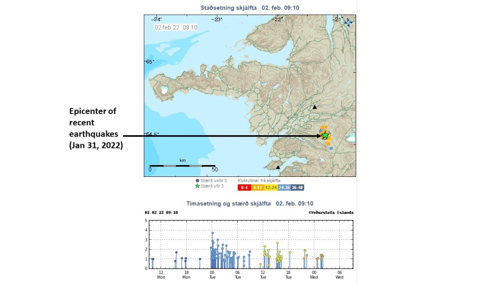
The earthquakes make people wonder – what is going on there? The location is outside the West Volcanic Zone and is by some regarded as intra-plate seismic activity.
This is a geothermal area, just south of the most powerful low temperature geothermal are in Iceland. Some large earthquakes occurred there in 1974 https://timarit.is/page/1453203#page/n0/mode/2up. According to the model considered here, with convection rolls found underneath, these earthquakes can be explained differently.
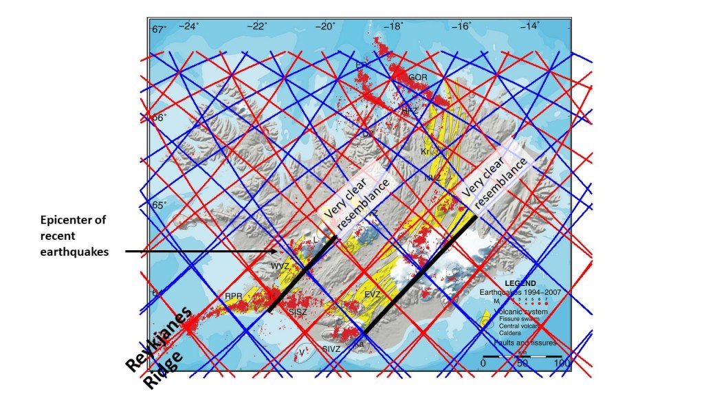
The location of epicenter can be compared with the West Volcanic Zone (WVZ), which closely resembles the East Volcanic Zone (EVZ) in many ways. The eastern margins of the WVZ and the EVZ are oriented in the same way, but the western margins differ.
The WVZ and the EVZ, the SISZ and the recent epicenters of recent earthquakes.
As the southern half of the WVZ is here regarded as a square, the N-S axis is vulnerable to shearing. The red lines west of the epicenter extend from the Reykjanes Ridge, and are supposed to be the up-welling division line between two convection rolls at the depth of 120 km, and another pair of convection rolls farther down, also up-welling. This causes tension, because the local convection rolls (in between red and blue lines) oppose the main drift of the North American Tectonic Plate, causing rifting. This causes earthquakes in the area, even though it is outside the WVZ as detected from the surface.
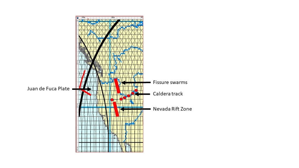
The Yellowstone Caldera is not alone. Many older remains of similar calderas can be found arranged in a row west of the presently active one. But there is something more about it.
The Yellowstone Caldera track.
Besides the calderas, fissure svarms and the Nevada Rift Zone are found north and south of the track. https://www.usgs.gov/observatories/yvo/news/just-how-long-has-yellowstone-hotspot-been-around?qt-news_science_products=4. These extra volcanic features are about 17 million years old, and show resemblance with the convection rolls presumed to be found underneath. The convection rolls theory can also explain the long features associated with the caldera. In Iceland, there are many volcanic systems combined of a caldera with fissures extending from it to the north and south. Another analogy is the fact that the Emeror Chain, considered to be a part of the Hawaii Chain, actually formed along a north-south aligned line, with volcanic activity propagating south until it reached the latitude of the present Hawaii hotspot. Therefore, the hot spots, such as Yellowstone and Hawaii, are actually short sections of ´hot lines´, extending secretly north and south of them, underneath the tectonic plates.
This year, 2021, it became the hobby of many people to climb the vicinity of Fagradalsfjall to watch the eruption of Geldingadalir on Reykjanes Peninsula of SW Iceland. Then, for three months, no lava was detected flowing from the craters, and we officially claimed that the event was over. (https://www.ruv.is/frett/2021/12/18/gosinu-lokid-en-afram-kvikusofnun-vid-fagradalsfjall?term=goslok&rtype=news&slot=6) Three days later, similar earthquakes started as preceded the eruption in March. As I have my own model to scrutinize the ongoing, there are a few things to be noted:
The dike keeps un-solidified in the dike for a rather long time after the eruption has stopped. A possible explanation is continuous flow taking place within it. The flow must have traceable beginning and end point. According to my logic, for those three months of quiescence, magma has been flowing smoothly into the dike from the NE, and out of it at the SW end. If nothing like this would have occurred, the relatively thin dike should have solidified.
The volume of lava already on the surface can be compared with some facts we know about its origin. (A) With petrological methods it has been found out that it has been melted at the depth of 14-16 km. It gives us the height of the melt zone of 2,000 -3,000 meters from the lowest to the highest level. (B) During the half a year, or so, the first chapter of the eruption lasted, 150,000,000 cubic meters of lava flowed on the surface.
We know that no indication is available about the real source of the magma. We know about the influx into the dike NE of the eruption site. We can not trace any magma chamber, no original inflow, no lowering at a place where magma might be flowing out to somewhere. We only notice that magma has been flowing into the dike and the related changes of its surroundings. These transactions take place within the ductile crust below Moho, where the flow can not be measured directly.
I would add a guess, according to my model, that the source of magma is found within the central axis of the Mid-Atlantic Ridge. That axis is actually the division line of two convection rolls, rolling opposite to each other, causing upwelling of magma along the entire Reykjanes Ridge. The line of division can be traced farther than the Reykjanes Ridge itself, and the perpendicular line from the eruption site and the relevant dike is 23 km long, or 23,000 meters.
We therefore have some information available. a) V=150,000,000 km3, b) h=3,000 m, L=23,000 m. We can the calculate that dike-like melting volume, within the ductile part ot the depth level between 14-16 km, 23 km long, would be about 2 meters wide.
Considering that not all magma should find its way to the surface, but maybe half of it, the deep-dike width should be about 4 meters. Moreover, the heat source is ascending molten rock, not finding its way to the surface.
The first melt has accounted for the first chapter of the eruption, but the heat source seems to be still actively adding to the melting process. If the eruption starts again, the petrological difference, evolving over time, could therefore indicate where the real source of magma is found.
This is one way in which we can explain the absence of measureable indications of the origin of magma, providing lava for the Reykjanes Eruption. In Iceland, the name is Geldingadalir Eruption, according to the area where the craters are found. The Geldingadalir valleys are at the side of Fagradalsfjall, a mountain of Reykjanes Peninsula.
A system of earthquake faults is traceable over the peninsula, and the mountain Fagradalsfjall. The eruption takes place through one of those earthquake faults, with N-S orientation at depth, but NE-SW trend at the top. The NE-SW aligned dike does cros the N-S fault at the side of the mountain, and there the eruption takes place. The system of earthquake faults does sway from the E-W oriented South Iceland Seismic Zone over the peninsula, only to become adjacent with the Reykjanes Ridge. As the faults become filled with additional lava, gravity anomalies develop as a result. This is a likely explanation why the so-called V-shaped ridges form semi-parallel to the Reykjanes Ridge. Those are not real ridges, but gravity anomalies due to this additional mantle material which has consolidated within the crust.
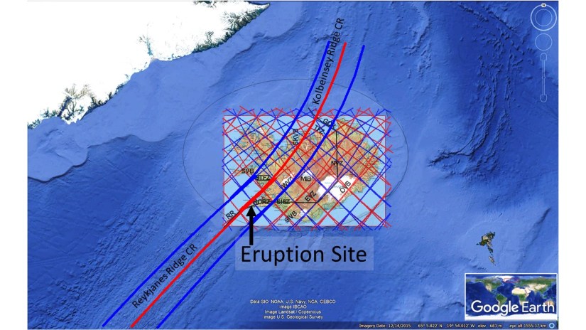
For basic orientation, I add this map:
The eruption site of Geldingadalir in context with the Reykjanes Ridge and the Kolbeinsey Ridge.
Hopefully, we can use this opportunity to learn more about the basics of this structure underneath, leading to volcanic eruptions, earthquakes and formation of geothermal areas.
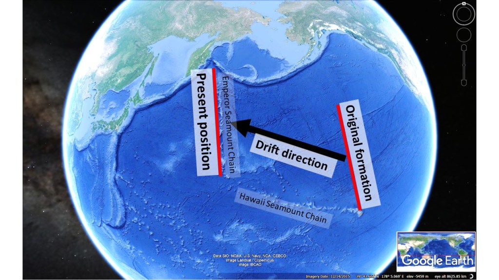
Most people think that the Hawaiian-Emperor Chain bends because the direction of tectonic drift changed. It is wrong, according to new evidence. The Hawaiian–Emperor seamount chain is divided, as the name indicates, into the Hawaiian and Emperor seamount chains. The Emperor part did form in a different way than the Hawaiian part. This is described by Foulger (2010):
Therefore, the picture of formation + drift processes looks like this:
Formation and drift of the Emperor Seamount Chain.
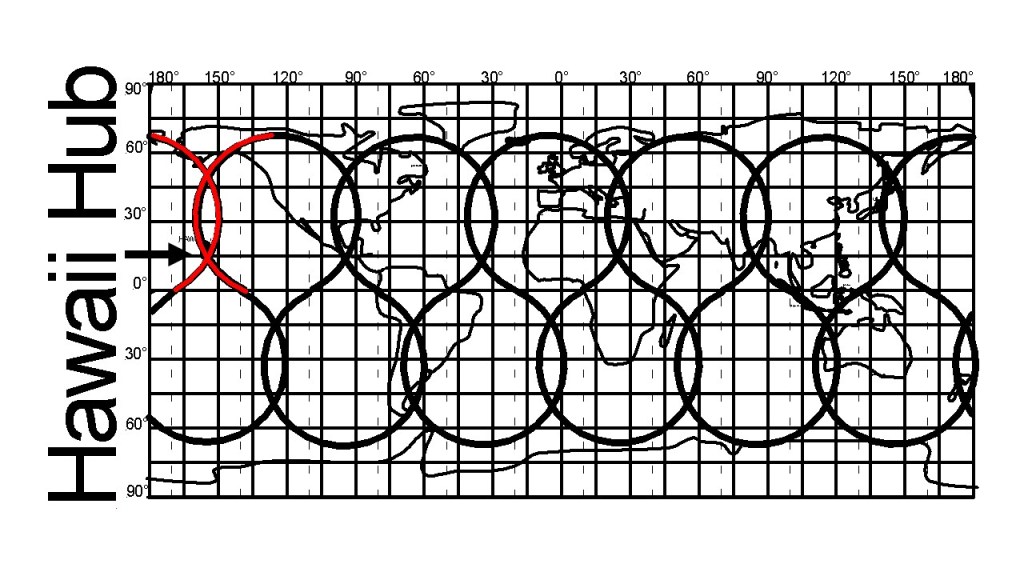
This can be compared to the convection rolls system shown below:
Haiwaii crossings of convection rolls division lines
It is quite obvious what has happened according to the Convection Rolls Model. The whole central line of the Pacific started to divide the plate, in the same way as the central ridge of the Atlantic Ocean. Before the division was complete, though, the Pacific Plate started drifting westwards, leaving only the hub of Hawaii active.
The volcanic zones of Iceland replace the Reykjanes Ridge in the south and Kolbeinsey Ridge in the north. This interval, found approximately between 63°N and 67°N, is as complex as the ridges look simple.
The volcanic zones of Iceland.
Here is a list of the zones: A = Snæfellsnes Volcanic Zone B = Reykjanes Peninsula Rift C= Western Volcanic Zone D = Central Iceland Volcanic Zone E = South Iceland Volcanic Zone F = East Volcanic Zone G = North Volcanic Zone H = Öræfajökull Volcanic Zone = I = Grimsey Oblique Rift J = Skagafjordur Volcanic Zone (extict). The red arrows at the bottom indicate mantle convection flow vectors (convective layer 1) just below 120 km depth. Names derived mainly from https://jardvis.hi.is/sites/jardvis.hi.is/files/Pdf_skjol/Jokull58_pdf/jokull58-einarsson.pdf
The drawing is superimposed on a map from the report from National Land Survey of Iceland: https://www.lmi.is/static/files/maelingar/isnlet2004-skyrsla.pdf. The map includes tectonic drift vectors showing shift of position of relevant points was measured with GPS technology within the time interval of 1993-2004.
Here the relationship between individual zones and a relevant pair of convection rolls is considered:
A – Snæfellsnes Volcanic Zone covers a pair of convection rolls, according to the model.
B – Reykjanes Peninsula Obique Rift Zone is not very well defined at its western end, because mapping is terminated at the coastline. It is not a proper geological border, but according to this model the system extends out to the beginning of the regularly aligned Reykjanes Ridge, before it starts bending eastwards towards the peninsula.
C – The Western Volcanic Zone, as defined, extends to the third convection roll in the north, but within that polygon the faults start bending northwards, in the same way as the rifts of D and F.
D – Central Iceland Volcanic Zone is mainly confined to only one polygon, except a part trending slightly west of north. It can be explained according to this model that the convection rolls of second layer affect the surface along the downwelling line.
E – South Iceland Volcanic Zone is itself very divided into the Eyjafjallajökull-Katla part and the Westman Islands part. Those two parts clearly cover a pair of rolls.
F – The East Volcanic Zone spans four polygons. But the central two polygons have a special status, being the only two clearly belonging to it. The southernmost polygon is divided into two parts, as a transition over to the South Iceland VZ (marked E). The northernmost polygon plays the role of transition over to the North Volcanic Zone, and has similar features as the polygon of the West Volcanic Zone at the same latitude.
G – The North Volcanic Zone, as defined here, extends over a pair of convection rolls, of convective layers 3 and 4. If we would define the NVZ as extending farther south (to Kverkfjöll Volcano), the zone would be seen covering two rolls of layer 1 and 2. A question of definition is met at the northern end, because it is submerged and not as clearly mapped as other parts.
H – Öræfajökull Volcanic Zone is a flank zone, clearly extending over a pair of convection rolls of the 4th layer, that is closest to the 410 km discontinuity.
I – The Grímsey Oblique Rift Volcanic Zone is hardly ever mentioned as a volcanic zone, because it is found under the ocean. Geologically, it has similar properties as the Reykjanes Peninsula. The upper most convection rolls below 120 km depth are found to mark the ends of this zone.
J – The extinct volcanic zone of Skagafjordur is most often omitted on simplified geological maps. The last eruption took place there less than 800.000 years ago, so the main features of Iceland were the same as today. The area is still geothermally active. Therefore, I tend to include this as a volcanic zone, specially because some rifting took place making Skagafjordur wider (perhaps 10 km wider) during a million years period of rifting process. https://orkustofnun.is/gogn/Greinar-starfsmanna/Arni-Hjartarson-2003-PhD/AH-04-Skagafjordur-Zone-an-ephemeral-Rift-Zone.pdf. The zone also seems to have covered a pair of convection rolls, of layer 4.
The volcanic zones, seem to fit quite well into sections of pairs of volcanic rolls. The model might therefore prove useful for a more accurate mapping and definitions of the outer limits of the zones, besides combining in the south with the Central Iceland VZ (D).
The four convective layers mentioned are found in between 120 and 410 km depth, the uppermost one labelled as convection layer 1.