Understanding the geological processes in Iceland and elsewhere, both tectonic drift and mantle currents have to be considered.
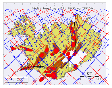
This map shows it all, tectonic drift vectors from the National Land Survey of Iceland. The grid of division lines superimposed on this map shows the outlines of convection rolls below Iceland. The convection rolls can not be measured yet, due to several reasons.
5 Core Factors + 2 Observables:
5 CORE FACTORS (causes in the mantle)
Temperature
Composition (chemistry)
Pressure / depth
Mineral phase (structure)
Partial melt / fluids
2 OBSERVABLES (what we measure)
Seismic velocity (Vp, Vs)
Attenuation (Q)
An addition to low resolution, these factors make it too complicated to get a clear picture of the vertical structure aspects of the mantle. But the methods used here to make the convection rolls model are a shorter way, thereby deducting these lines before modern sensors, relevant AI and other types of technology provide direct observation opportunities.
Each of those lines shows the division between two convection rolls, found below Iceland at different depth, but all of them affect the tectonic plates of N-America and Eurasia. The first demonstration is how the volcanic zones follow the scope of the convection rolls. The only way to explain this consistency is finding out how those division lines affect the tectonic plates (and the crust). Ignoring this consistency would be wrong.
This leads us to consider further what happens down below, within the asthenosphere, the transition zone of the mantle, and the lower mantle. These lines are really narrow and sharp, so the way magma ascends through the tectonic plate should be analysed. The only way is the accumulation of martial melt exactly where the division lines are found, a mechanism of the convection rolls to release the partial melt there and make it possible for the lines of ascending magma to proceed all the way upwards, a distance of 120 km.
With this in mind, a myriad of geological features can be explained, hitherto hidden and not understood.
As can be seen on the map, the tectonic drift vectors are remarkably parallel to the convection rolls. This is a mathematical coincidence, found at the starting point of tectonic drift of the two plates. Farther out, this consistency is not seen, as the two plates drift and rotate in their independent ways.
