It is well known that the interplay between volcanic and seismic zones is at work on the Reykjanes Peninsula. The peninsula is being pulled apart by the same forces as shape the Mid-Atlantic Ridge, and that is by definition a divergent effect. This causes the volcanic fissures to open up, being aligned from SW to NE. The dykes responsible for the eruptions have the same alignment, being in the same direction as the model used here. It is important that a mathematical formula can be used to calculate alignment of volcanic dykes, and it also adds to the credibility of the theory that convection rolls are found underneath the tectonic plates.
The seismic area of Reykjanes is bent, but the seismic faults are oriented N-S within the bent area. In addition, the Reykjanes seismic area extends from the South Icelandic Seismic Zone. These two seismic zones are therefore connected, and the connection point is also the point connecting two polygons of the convection rolls model. The Reykjanes seismic zone is formed due to compression of the area, perpendicular to the extension due to the divergent effect of the Mid-Atlantic Ridge. These pressure vectors are quite comparable to those of the South Iceland Seismic Zone.
What makes the Reykjanes Seismic Zone special is the fact that it is bent, making it possible to connect the Reykjanes Ridge and the South Iceland Seismic Zone. The two different forces therefore become compatible, resulting in a wholistic and logical drift system.
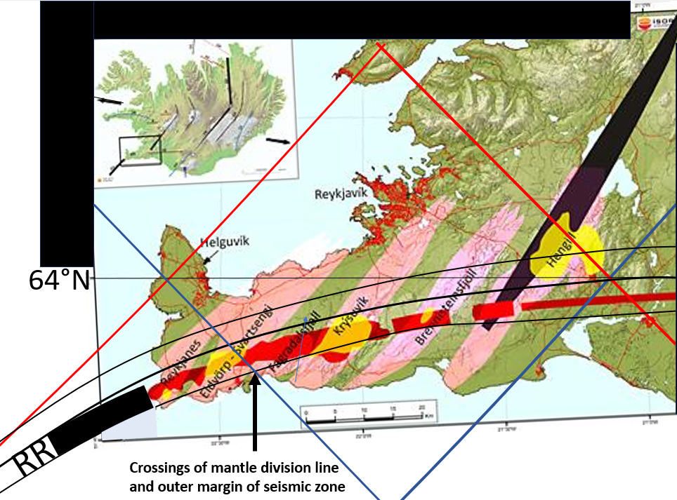
Superimposed blue line, showning mantle divisions, crosses the seismic and volcanic areas on the Reykjanes Peninsula, pointed out with an arrow on the map. Volcanic systems on the Reykjanes peninsula are shown in pink. The red lines indicate the tectonic plate boundary, where earthquakes are common. Geothermal areas are marked in yellow. Black lines indicate fissure swarms. Modelled division lines and the outlines of seismic zones are superimposed on a map base from ISOR.
The main active areas are found within the southern half of the bent seismic area, as it extends from the South Iceland Seismic Zone.
Comparing the model with the basics of the Oblique Rift Zone of Reykjanes does not explain the present activity to a full extent. On the other hand, it shows that the present event brings into light the combined effect of several factors, mainly the volcanic fissure swarms, the seismic zone, and the mantle rolls division lines.
A scientific approach to these three combined factors would be to compare them with petrological and seismic evidence, along with other information available about surface movements. That could answer many questions.
Not much is known about the source of this magma. It is only possible to trace its history with some degree of accuracy from the time when it is already being accumulated somewhere within the tectonic plate. The energy necessary to provide the magma is only found below the tectonic plate, and therefore the flow should be traced all the way down to the depth where convection can take place.
