When GPS was used to measure tectonic drift, the tectonic equator appeared.
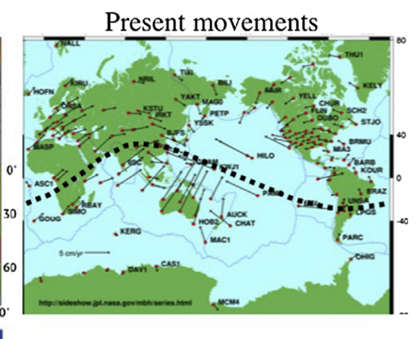
This tectonic equator, as described by the GPS Nasa database, does cross the rotational equator at two locations, and the most intriguing point is at the Great Rift Valley of Africa. The alignment of the tectonic equator follows that of the convection rolls, being about N65°W. The two equatorial lines of rotation and tectonics then cross each other again 120° farther to the east in the Pacific Ocean.

The southern half of the tectonic equator covers 240°, twice that of the northern half, mainly because its curvature is enlongated over the Pacific Ocean. The Pacific Rise fits into that pattern, being the starting point of the Pacific Plate, extending over to the Asian coast.
One aspect of the tectonic equator is the fact that it reaches the limits of 32°N and 32°S. The latitudes of 32° include the central points of the mathematically circular shape of the convection rolls, and therefore the alignment there is exactly N-S. All of this follows the mathematics of the sphere, or more precisely, the geoid.
What is not considered here in context with the tectonic equator, is the rotation of North America. It rotates in a similar way as the African-Eurasian complex, but with a smaller radius, apparently only equivalent to 90° along equator, not 120°.
I can point out this consistency, the exact driving mechanism of convection rolls leading to the tectonic drift is a bit complex to derive and explain. But with the Convection Rolls Model derived and the exact information about tectonic drift vectors, the functions can easily be modelled and understood. The same consistency between convection rolls alignment and tectonic drift vectors is found in NW and NE Iceland, indicating the functionality of convection rolls at these locations.
