Looking at the grid formed by the division lines of the convection rolls, together with the division boundary within the tectonic plate itself, we can identify crossings located precisely where uplift is occurring.
Crossings Between Tectonic Division Boundaries and Mantle-Roll Boundaries on the Reykjanes Peninsula
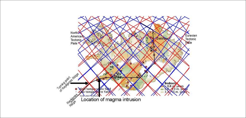
The broad curvature of the tectonic division boundary extending from Hveragerði to the Reykjanes Ridge is mirrored around a point near the Blue Lagoon and Grindavík. This is also the area where the recent uplift center has developed.
Geologists have discussed why the uplift center is located close to the geothermal power plant, west of the Sundhnúkur crater row and the associated dyke intrusion system. Current observations indicate that magma initially flows eastward from the deeper reservoir before entering a dyke system aligned NE–SW.
However, when the mantle-roll division boundaries are included in the model, the geometry becomes easier to visualize. In this interpretation, one of the deeper mantle division lines is aligned NW–SE beneath the area. This alignment may provide a structural pathway guiding magma movement upward and slightly toward the southeast. After reaching shallower crustal levels, the magma flow then makes an approximately 90° turn and enters the NE–SW-oriented dyke system associated with the Sundhnúkur eruptions.
This arrangement suggests that the magma transport system may reflect the interaction of two different structural controls:
- the deeper mantle convection-roll boundary system, influencing the initial ascent and lateral transport of magma, and
- the shallower tectonic rift geometry of the Reykjanes Peninsula, which controls the orientation of the dyke swarm and eruptive fissures.
Seen this way, the location of the uplift center west of the crater row is not necessarily anomalous. Instead, it may represent the point where these two structural systems intersect most effectively, concentrating magma accumulation and crustal deformation in a predictable geometrical position.
The regular bow of tectonic division line from Hveragerdi to the Reykjans Ridge is mirrored around the point close to the Blue Lagoon and Grindavik. The point of uplift is therefore central to the system, connecting the Reykjanes Ridge and the so-called South Iceland Seismic Zone.
