Uncategorized

Langisjór – representing the Eastern Volcanic Zone

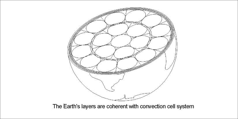
Langisjór is a world of its own, and so important to geology. As it is a very long feature, about 20 km, it shows the main alignment of the relevant volcanic zone quite well. The world’s mantle convection cells are arranged according to the formula used here, and it is exhibited quite clearly at Langisjór:

Langisjór - alignment

The accuracy is a proof that this is the correct way to compare surface features with the system of convection currents underneath, as shown in a previous post about Langisjór.

Uncategorized

Skógafoss – the regular A4 shaped waterfall

The most regularly shaped waterfall is Skógafoss, like an elongated page of a book. Let us have the same kind of analysis as for the the other famous waterfalls at hand.

20171227_105055

There was not much water in it during the winter time, but the edge of it can be clearly seen. From above the alignment can be measured and compared with calculated direction of convection rolls:

Skógafoss - 01

No surprise, because it fits exactly to the expected value.

And above Skógafoss there are at least 25 smaller falls within the Skógá river. Are they aligned according to a formula too?

Uncategorized

Goðafoss – aligned like other waterfalls

There is one famous waterfall still not mentioned here. It forms a semi-circle, but the sections have certain alignments. This is the main one:

20180617_100020

Looking from above with the help of Google map, the alignment can compared with calculated direction of convection rolls underneath:

Goðafoss

The river Skjálfandafljót makes a turn before it reaches the fault responsible for the waterfall. The alignment is the opposite of Dettifoss (but the same deviation from north), and the same as for Selfoss in Jökulsá á Fjöllum.

Again, a composition of differently oriented faults combine at the site of the waterfall.


Faxi

Dynjandi


Uncategorized

Kleifarvatn – a lake between tectonic plates

Kleifarvatn is dividing N-America and Eurasia. The Krýsuvík volcanic system includes the lake with geothermal areas found both on its bottom and around it.

Kleifarvatn

A view to the NE over Kleifarvatn

You can say that the mountain on the left hand side belongs to America and Europe is on the right hand side. The lake has no rivers, but after earthquakes occurring in the year 2000 the water level lowered whereas fissures in the area opened up, making way for water flow towards the ocean.

Kleifarvatn - a lake between continents

The alignment of the Sveifluháls tuff ridge can be calculated directly as it follows the polar convection cells. At 64°N the equatorial and polar convection cells are aligned the same way.


Uncategorized

The Bridge Between Continents on Reykjanes Peninsula

The Bridge Between Continents on Reykjanes Peninsula is a popular tourist attraction. It is located at the western edge of the rift valley formed along the volcanic system of Reykjanes. Bridge Between Continents

The rift follows the direction of the polar convection cells, as shown here on Google map:

Bridge Between Continents - Reykjanes

The outstanding part of the rift, with the bridge over it, is close to another less prominent feature. It is found to be due to horizontal tectonic force, as the angle is half of the other compared with EW-axis. The rift is supposed to have been deepened by the combined effect of these two tectonic alignments.

This is very similar to the settings of the Almannagjá rift of Thingvellir National Park, where the combination of tectonic alignments forms high walls at the side of the rift valley.