Comparing Iceland and Norway at the same latitudes 30° apart should lead to some analogy due to the same pattern of convection rolls. Here is an example.
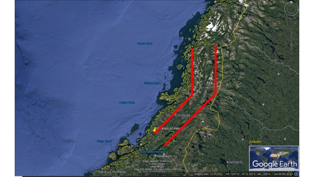
East and North Volcanic Zones of IcelandMap of Norway with markings 30° east of the East and North Volcanic Zones of Iceland
The similarity is quite striking. A NS-structure is found accurately 30° east of the North Volcanic Zone of Iceland, which is aligned exactly NS. The bending structure connecting with the NE-SW oriented East Volcanic Zone of Iceland is found exactly at the same latitude in Norway. In addition, the points 30° apart, of Hekla in Iceland and in the Trondheim area in Norway, are aligned exactly in the same way.
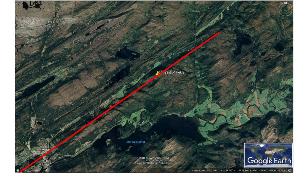
The consistence between Hekla and its counterpart exactly 30° to the east is hard to explain. Hekla is on the 64th parallel, 19°40’W. 30° farther to the east on the 64th parallel, namely 10° 20’E, the landscape is oriented exactly the same way as Hekla. The volcano Hekla is a bit special, located in between the Eastern Rift Zone and the South Iceland Volcanic Belt. Therefore it is not pulled apart with the rift zone perpendicular to the convection rolls. The sideways drift of the tectonic plates therefore influences its alignment. It can be calculated as: A=(C+C/2)/2, where C stands for Convection orientation, and A is the allignment direction, in this case W35°N.
Hekla.Norway 30° to the East of Hekla.
In Norway, there is no rift zone, but similar pressure vectors can occur, as the polygon pattern within the durctile part of the tectonic plates is exactly the same at these locations. That explains identical orientation of the topography.
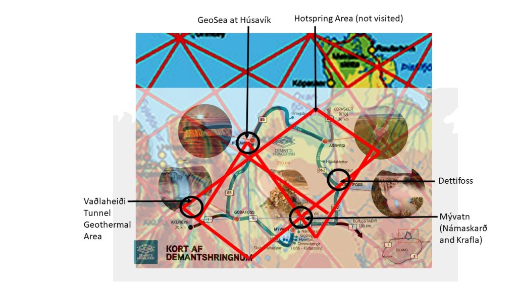
Scenic areas appear in context with forces of nature. The Diamond Circle contains Goðafoss Waterfall, Mývatn Lake, Dettifoss Waterfall, Ásbyrgi Canyon, Húsavík Hot Springs and eventually the town of Akureyri.
Scenic Areas of Diamond Circle
Here some explanations are made:
1. Vaðlaheiði Tunnel goes right through a division line between mantle rolls. 2. Goðafoss is at the EW axis of the relevant polygon. 3, Mývatn area with Krafla and Námaskarð are located ath the edge of a mini-polygon. 4. Dettifoss is at border line of two polygons, providing conditions for a division between highland and lowland areas. 5. Húsavík is on the main division line of lower mantle. At Öxarfjörður a major geothermal area is found, still not included in the circle. The polygons provide clear topographical NS features, including Ásbyrgi.
Dettifoss Alignment Calculated According to Mantle Current Flow
The tectonics of the area of Dettifoss follow the upper most convection rolls of 120 km below the surface. The formula shows exactly the direction of the tectonic feature creating the edge of Dettifoss Waterfall.
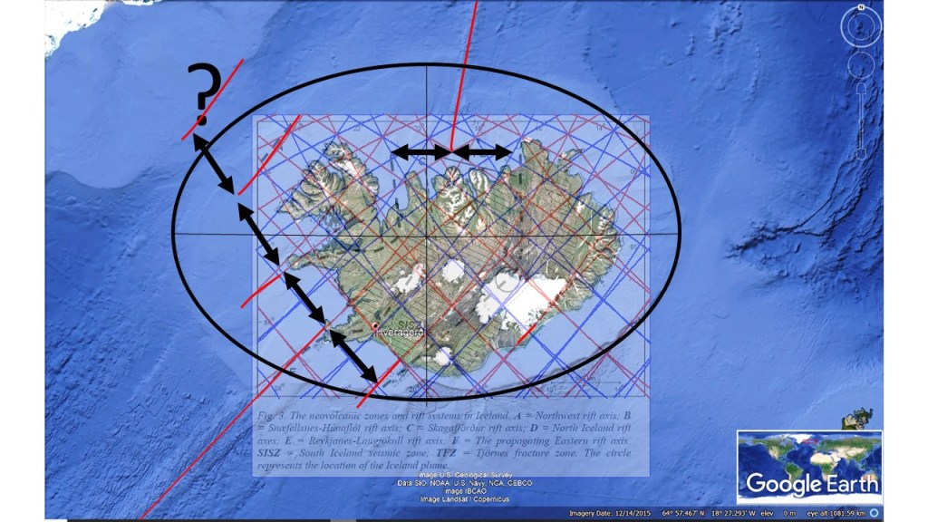
Drawing a continuation of the two ridges, Reykjanes Ridge and Kolbeinsey Ridge, they meet in one point. This point is also central to the elliptical form noticable of the Icelandic Shelf. This form has developed gradually, as different rift axis have been replacing each other through millions of years.
Central Point of Iceland
The yellow lines are the theoretical continuations of the two ridges found north and south of Iceland, until they meet at one point.
The NS axis goes right through Hekla and Eyjafjallajökull in South Iceland. In turn, Eyjafjallajökull forms a similar ‘small’ ellypse, around the same axis, as shown here:
Central Axis of Iceland Shelf and Eyjafjallajökull
The central point forms the crater of Eyjafjallajökull. The EW axis of the polygon connects Eyjafjallajökull and the Katla System.
Considering the jumps of rift zones over Iceland, and seeing the pace of those ‘jumps’, there seems to be a possibility that another rift zone opened before the ‘first one’.
Was there another Rift Axis?
The activity would then have occurred about 25 million years ago, probably at the same time as when the Northwest Rift Axis was active. The prospective rift axis is pointed out with a question mark.