Uncategorized

The Mirrored Oblique Rift Zones of Iceland – Reykjanes Oblique Rift Zone and Grimsey Oblique Rift

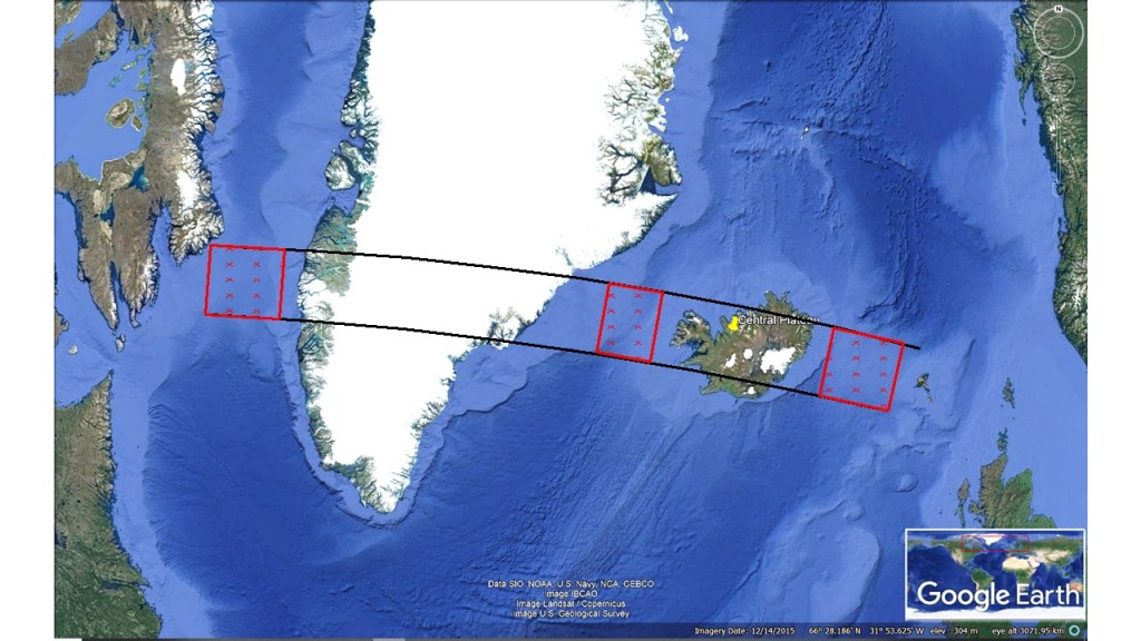
Similar oblique rift zones connect the Icelandic volcanic zones with the two mid-ocean ridges, Reykjanes Ridge and Kolbeinsey Ridge. When compared, the length of those two oblique zones appears to be exactly the same, and even the shape of them is alike. Considering that those areas have the same function, as they are reacting to similar effect of the tectonic drift, it is maybe not so strange. When compared to the convection rolls model, this picture emerges:

Identical (or mirrored) oblique rift zones

If put together, these zones form a triangle with three equal sides. The tilt of the triangle corresponds to the divisional vectors of tectonic drift in Iceland. The areas have the characteristics of both volcanic and seismic zones. Reykjanes Oblique Rift Zone is much better known, as it is largely found on land, but the part of it found offshore seems often to be neglected. Recently, more information has been gathered about the Grimsey Oblique Rift, often referred to as the Grimsey Lineament or the Grimsey Seismic Zone.

The end points of both oblique rift zones can be compared, as in the South, the main division line over Iceland is directly E-W oriented, whereas the end point in the North connects to a line directly N-S oriented. The other end points connects the zones with the regularly shaped mid-ocean ridges. The bending of the oblique zones takes place within the grid of polygons in a formidable way. Following the division between tectonic plates along the Reykjanes Ridge looks easy, as it follows one single line with a simple formula. Then is starts bending off the track, leading to the formation of Reykjanes Oblique Rift Zone. Then the E-W part takes over, with the South Iceland Seismic Zone and the East Volcanic Zone, respectively. Following the division along the eastern edge of the East Volcanic Zone leads us to the turning point at Kverkfjöll. Then we have a direct N-S line through the central axis of the North Volcanic Zone, all the way to the Öxarfjordur Bay, where a sharp turn is made for the Grímsey Oblique Rift. As has been dealt with in other posts, there are other faults of the Tjörnes Fracture Zone making the situation out of the north coast of Iceland more complicated, with a triple system of the Dalvik Lineament, Husavik-Flatey Lineament along with the Grímsey Lineament (here dealt with as Grímsey Oblique Rift Zone). From the end point, where a volcano called Storagrunn, the Zone is connected with Kolbeinsey Ridge, completing the main division line between the N-American Tectonic Plate and the Eurasian Tectonic Plate.

Some material about this subject is found here:

.https://www.researchgate.net/publication/225195779_First_results_from_the_North_Iceland_experiment

https://en.wikipedia.org/wiki/Geology_of_Reykjanes_Peninsula

Uncategorized

The Break-up of Pangea and the 30° Interval Pattern Along Equator 200 Ma

Just as 30° separate main topography of the world at equator today, a 30° pattern can be recognized of Pangea 200 million years ago. The convection currents must then have been coupled and de-coupled in a favorable way so that breakup of the tectonic plate could take place. The breakup occurs mainly along the main division lines of lower mantle large scale convection rolls as shown here.

Pangea 30° pattern along equator. Superimposed on Wikipedia map.

It is notable that Iceland during that time was located over a large scale downwelling line (the third from left in the drawing). During the breakup, the area where Iceland is now located moved westwards over to the next division line, namely the upwelling line of the center of the present location of the Atlantic Ocean.

.https://en.wikipedia.org/wiki/Pangaea

To clarify further, what has happened after the break-up of Pangea, you can have a look at this drawing of the equatorial plane of the Earth, showing the convection rolls pattern.

Comparing the distribution of land mass along equator with convection rolls system.

To compere with upper drawing, The red marking here corresponds to the second line of the world map above. The upwelling division line did break S-America away from Africa, and then S-America drifted directly westwards over to the other convection roll. The same happened to Africa, but it also drifted northwards, so that now it only spans 30° from east to west. The northwards, and more irregular drift also led to the fact that the coastline is slightly east of the division line, leading to the formation of the Great Rift Valley over the corresponding upwelling large scale division line.

It is interesting that Indonesia has not altered its position according to the map from Wikipedia shown above. The equatorial pattern of 30° intervals is therefore maintained for both 200 Ma and present. For clarity, this drawing can therefore be added:

This is how it looks with 200 million years interval. It would have been nice if we could have measured the drift step by step when the Atlantic Ocean was getting wider at equator. That process is of course still ongoing in general. We can measure the tectonic drift every day now, so this should not be a mystery to be solved. The puzzle of Pangea has been reconstructed accurately because we have thousands of high quality measurements to rely on. Therefore, these two cross sections of equator can be drawn.

Uncategorized

The Amphipoda of Lake Thingvallavatn – the oldest manifestation of Iceland?

It was in the year 1998 that Bjarni Kr. Kristjánsson biologist found a type of amphipoda in Thingvallavatn. It has now got the scientific name Crymostigius thingvallensis. The amphipoda has now also been found at Herðubreiðarlindir in NE Iceland. Similar amphipoda can be found in Ireland and South England in the east, and at the border of Canada and the US in the west. Therefore, it is reasoned that Crymostigius thingvallensis has evolved independently at the location for millions of years, from the time when the two continents of Europe and America were connected.

Thingvellir Rift Valley at the northern end of Thingvallavatn Lake.

The area is said to separate the two tectonic plates of N-America and Eurasia. The finding of the Crymostigius thingvallensis is assuring. Today, geologists tend to emphasise the tectonic drift factor, pointing that the main division line is actually south of Thingvellir Rift Valley, so the area is the division line between Hreppar miniplate and the N-American Tectonic Plate. With our amphipoda, it should still be possible to claim that the area is a long term border area due to tectonic drift. That means that favorable conditions are prevalent for millions of years due to the pulling effect of pemanent mantle currents underneath. The rocks seen in the picture are only 9.000 years old, as the rifts constantly renew themselves, and new lava fields add nutrition to this very special lake.

.https://www.thingvellir.is/fraedsla/nattura/lifriki-vatnsins/

Uncategorized

Center of the Atlantic Ocean – what happens along equator?

The two parts of the Atlantic Ocean are clearly divided along equator. The central point can be defined, because the Atlantic is exactly 60° wide along equator from Amazon Esturary to the West Coast of Africa. The equatorial part of the Mid-Atlantic Ridge then reaches equadistant to east and west, accurately 9° to each direction. That is equavalent to 6 convection rolls, as each convection roll spans 1.5° from east to west.

Center of Atlantic Ocean

The two ridges are then formed differently, one following the main swaying trend of convection rolls (North Atlantic) and the other follows the NS-trend of the convection rolls system (South Atlantic). Similar difference can be observed on small scale in Iceland, where in the southern half of Iceland the alignment is NE-SW, and then shifts to NS-alignment in the northern half. In turn, we have to analyze why nature makes these ´different choices´, and likewise we should try to explain why we find symmetry of nature as shown here.

The large scale convection rolls of lower mantle are not drawn here. They span 30° from east to west, so the thin yellow line represents the pair of lower mantle convection rolls along equator.

Uncategorized

The Formation of the Atlantic Ocean

The Atlantic Ocean is mainly formed by two gigantic convection rolls. In between them, the Mid-Atlantic Ridge actively forms new oceanic crust out of basalt. The North and South Atlantic look similar, and here we will have a look at both the similarities and the differences. There are four main sections with 32° interval from north to south.

The basic features shaping the Atlantic Ocean (superimposed on map from Wikipedia)

Within part 1, the ridge and rolls division line are unified along Reykjanes Ridge (offset by 1.5° west), but sways east of the convection rolls division line south of the Reykjanes Ridge. Both ridge and convection rolls division line intersect each other at 32°N. The reason is that at 32°N the convection rolls are oriented directly NS, so it becomes a latitude of division between different sections of the ridge.

Within part 2, the ridge sways slightly west of the convection rolls division line. A part of Africa still sticks out into the Eastern Convection Roll Area within that section.

Within part 3, the ridge is almost directly oriented NS, giving the South Atlantic part a slightly different appearance than the North Atlantic. The section includes the highland of Southern Africa, marked by the outer limits of the convection roll. At 32°S, the eastern division line crosses the coastline.

Within part 4, the Ridge makes a turn towards east. The arc shaped ridge makes the turn around the convection rolls division line, also marking the end of the real Mid-Atlantic Ridge.

It is notable that the western foothold point of Greenland at 64°N is of the same nature as the eastern foothold point of Africa at 32°S.

In this way, we get a glimpse of the main constraints forming the Atlantic Ocean during the present era. A NS-axis can be marked from equator to Iceland and through the South Atlantic. This NS-axis is the same as can be found when examining the details of Icelandic geology, both volcanic activity and the Icelandic Plateau.