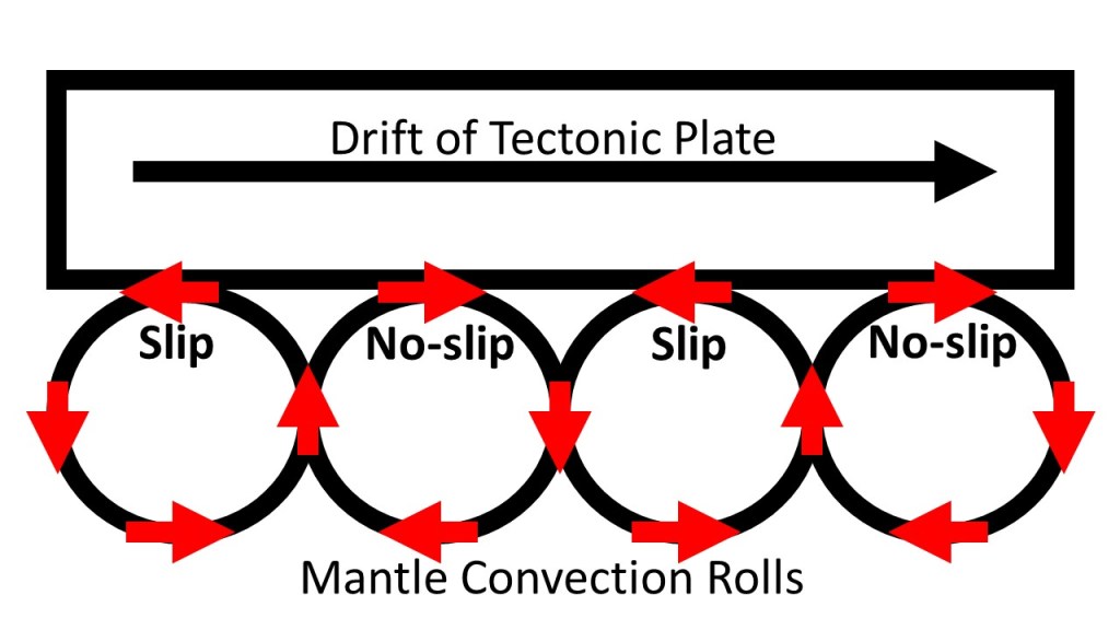
Tectonic drift has to be powered with convection currents. The currents do not work against each other due to slip and no-slip conditions. When a tectonic plate has started drifting into a certain directions, those convection rolls rolling with it also connect with it firmly, but those rolling the opposite way loose the grip. This is due to the fact that the mantle is very close to melting point, so extra friction causes melting, but less friction causes solidation.
Slip and No-slip resulting in tectonic drift.
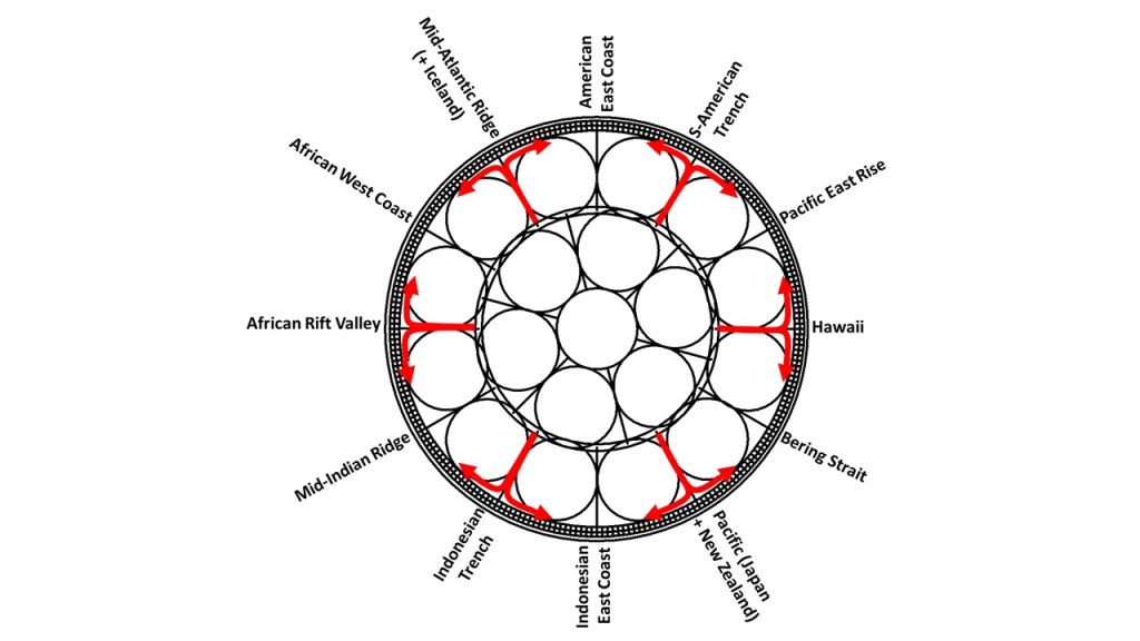
The large scale and small scale convection rolls then work together according to this picture:
Main points of main convection rolls division lines.
The small convection rolls found below the tectonic rolls therefore play a big role in inducing the tectonic drift.
We relate the Reykjanes Peninsula to the Reykjanes Ridge. It is so obvious that the peninsula is a continuation of this part of the huge Mid-Ocean Ridge of the Atlantic. But looking below the crust, things become somewhat different. The convection rolls of Reykjanes are subducted by the Kolbeinsey Ridge Convection Rolls, and therefore the magma now flowing as lava at Fagradalsfjall is not the same as that of the main part of the Reykjanes Ridge.
SS
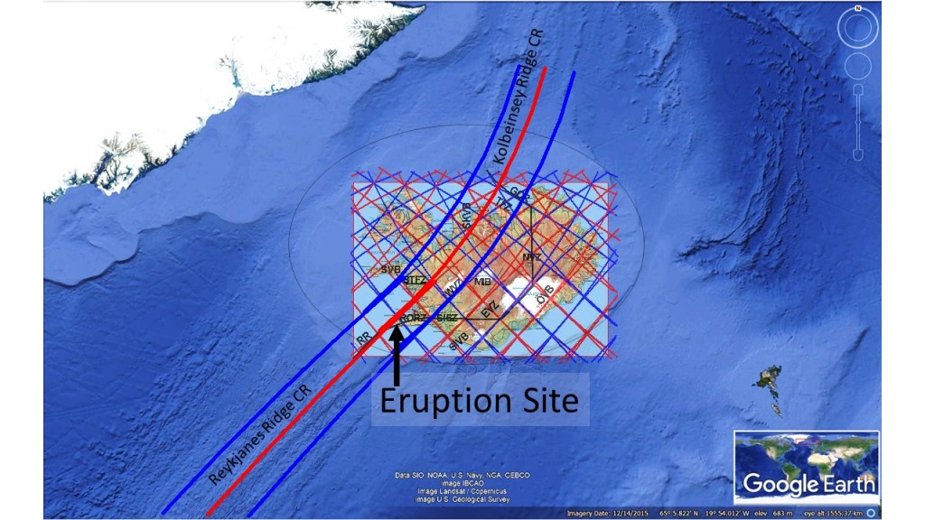
The subduction can be shown graphically as here below:
The two systems of convection rolls intersect between 60.7°N and 67.3°N, and the northern rolls are found over the southern ones.
The dike of the eruption site of Fagradalsfjall makes a turn that must be explained. The magma found its way from the vicinity of Keilir and propagated SW towards Fagradalsfjall. Then it made a turn directly south, just to make a turn again farther south in the same direction as before. All this is in harmony with the magical shape of Fagradalsfjall. It is actually diamond-shaped, about 3.5 kilometers on each side. The deviation from north is the same for all sides, and the alignment is accurately the calculated value for convection rolls.
The dike of Fagradalsfjall, responsible for Geldingadalir eruption. Map from the University of Iceland inserted, showing the predicted dike location.
The mountain clearly has a NS-axis, and almost as clearly an EW-axis, although the westernmost corner is missing. The sides have the same alignment as the dike, and it makes a turn apparently where it meets with the EW-axis of the mountain. The NS-direction of the dike can be explained with the existence of NS-oriented earthquake faults in the area. Farther south, the dike again propagates along the SE-side of the mountain, as large faults are found there aligned NE-SW.
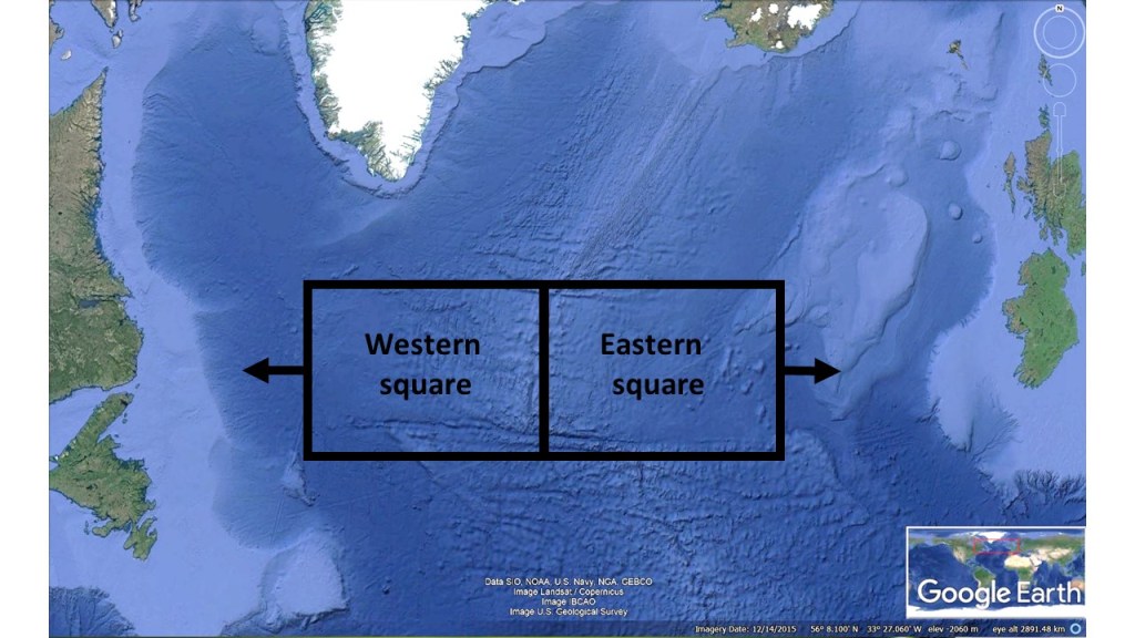
Reasoning the obvious: There are E-W trending faults on the ocean floor all around the globe. Here is an example from the North Atlantic. The reason is simple, namely the way material breaks up due to the forces around, and in this case the forces are regulated by the effect of Earth’s rotation. The flow of magma, and thereby the mantle convection rolls have to sway accordingly, and northwards horizontal flow has to be symmetric to southwards horizontal flow. The result is a mantle pattern symmetry along N-S and E-W axis, and therefore these structures aligned in the main directions appears quite often.
E-W trend of Central North Atlantic Ocean Floor.
The huge forces creating this pattern should not be underestimated. The convection rolls of lower mantle have created the Atlantic Ocean, slowly but steadily over millions of years. Perhaps this is too big for modern science to investigate properly. We want details and accurate measurement. This is too big to imagine, and how to measure the size and power of it? The answer is that we can not detect the mantle flow with enough accuracy for scientists to provide reasonable results. Therefore, I have chosen an inverse way to decipher the convection rolls system, introduced piece by piece on this website.
Fracture zones on the ocean floor often follow an east–west orientation. One example is the Charlie–Gibbs Fracture Zone. Between this fracture zone and the main section of the Reykjanes Ridge, part of the Mid-Atlantic Ridge runs directly north–south, a trend that also occurs frequently elsewhere.
In this case, two large tectonic domains emerge, both bounded to the south by east–west structures, while the division between them is oriented north–south. On a very large scale, this resembles the same structural pattern observed in Iceland. There, the southern part of the country is characterized by volcanic zones trending northeast–southwest, whereas the northern part contains volcanic zones trending north–south. Both systems are consistent with the structural possibilities provided by the mantle convection pattern beneath them.
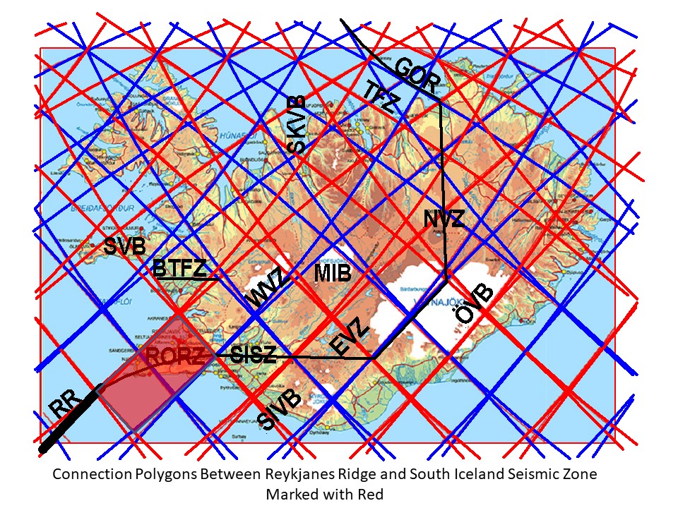
The volcano now erupting in Iceland has often not been included as an independent volcanic site on geology maps. It is a bit embarrassing now when Fagradalsfjall Volcano and the eruption site of Geldingadalir has become world famous. The volcanic zone of Reykjanes has a few volcanic systems, arranged en echelon along the peninsula from west to east. Having a model where the origin of magma is traced to the Mid-Ocean Ridge of the Atlantic Ocean, namely the Reykjanes Ridge, the result can be described with these maps:
The investigation area is marked with red.Simplified polygons superimposed on map from Reykjanes Geopark.
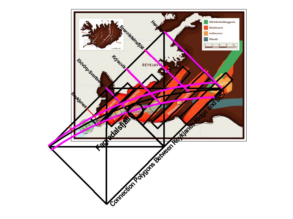
Many different details make maps unclear, so down below is the same map slightly clarified:
The volcanic systems shown schematically in context with model. Upwelling convection rolls division line extending NE from Reykjanes Ridge (RR) is supposed to feed the volcanic systems.
Ttectonic drift causes upbreaking within the polygons, providing channels for vertical influx of magma. First, the magma flows below Moho, within ductile material, and unnoticed on the surface, causing virtually no earthquakes. Then the magma breaks into the brittle part of the tectonic plate, at Reykjanes found at the depth of about 15 km. After that, the magma tends to create dikes perpendicular to the original flow direction, namely NE-SW. This takes place at the boundaries between the two tectonic plates of N-America and Eurasia. At the Reykjanes Peninsula the line is actually a few kilometers wide area, found in context with the Reykjanes Ridge on one hand and the South Iceland Seismic Zone on the other hand. A central axis can therefore be defined, and a distinct seismic zone that can be traced along the entire peninsula in context with the division line between the plates. The volcanically and seismically active areas are mainly found south of the theoretically central division line, here marked with a black curved line along the peninsula. The horizontal magma flow is then found to occur along the division lines between polygons, and two lines appearing as the polygon gives in to the tectonic drift effects.
As a result, the volcanic systems of Eldvörp-Svartsengi, Krýsuvík, Brennisteinsfjöll and Hengill, are found directly in context with the magma flow, both within and at the sides of, the Reykjanes Polygon. The high temperature areas are found where the southern margin of the seismic zone crosses the volcanic systems. One system is defineable at the westernmost end, called Reykjanes Volcanic System, but according to the model it has its origin within the next polygon to the south-west.
Fagradalsfjall is clearly missing from what is said above, but likewise it is obviously erupting, so why is that? Looking at the model drawing, the opportunity for the magma flow mainly feeding the Krýsuvík Volcanic System, to ascend earlier through a weakness zone arises, where it crosses the main, central division line between the tectonic plates. This time, it should have happened according to this model, and the magma created a dike aligned towars S-W, triggering the eruption.
The feeding line of Krýsuvík Volcanic System is also responsible for the Fagradalsfjall Volcanic Systems, because the division line is forced to bend along the polygon, in order to make the connection between RR and SISZ possible. Likewise, it can be difficult to distinguish the division between Reykjanes Volcanic System and Eldvörp-Svartsengi Volcanic System. Therefore, for a long time, some geologists have only talked about four volcanic systems of Reykjanes, while others have seen six different systems.