Uncategorized

The Consistency between Reykjanes Ridge and other Volcanic Areas of Iceland

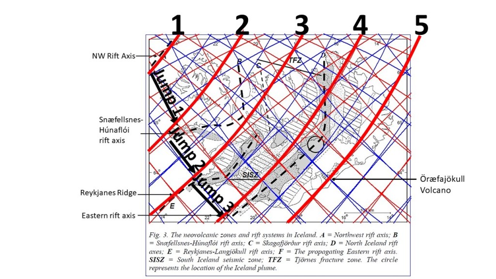
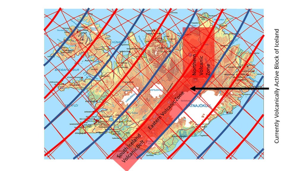
The location and alignment of the Reykjanes Ridge is consistent with both older and newer volcanic areas of Iceland. It can be shown that five parallel areas of volcanic activity have developed durning the last 24 million years. Moreover, they follow the model of convection rolls closely:

Timing of volcanic activity in Iceland

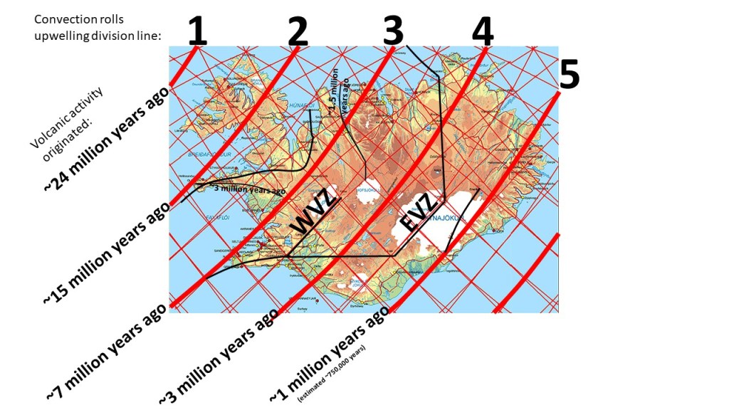
The timing is marked in the map according to this table:

Rift zones and rift jumps

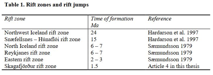
The table is from https://orkustofnun.is/gogn/Greinar-starfsmanna/Arni-Hjartarson-2003-PhD-heil.pdf

This regularity forms a base for us for realizing the real nature of what we call ‘rift jump’. Also, it shows that the convection rolls under the country marked with wide red lines are quite dominant when it comes to volcanic activity and rift process. Nature is not simple, so the other layers underneath also affect the surface. Therefore, to fully analyze the formation of Reykjanes Ridge, the related volcanic zones and volcanic belts, the whole pattern of convection rolls has to be taken into account. Remember that the wide, red lines are upwelling lines. In between, there is one line (thinner) that is downwelling. Thereby you can visualize the scope of each convection roll extending NE-SW (at 120 km depth). When more familiar with the system, you can also visualize the lower layers with additional convection rolls.

Uncategorized

The Five Equal Steps of Volcanic Activity in Iceland

The rift zone ´jumps´ in Iceland are well known, occurring every 7 million years or so. The central axis of these zones have been mapped, and the regularity of interval between them can be detected easily. One volcanic zone has hitherto not been included, because it is not a rift zone. All the same, it fits into the pattern of regularity. The wide red lines are upwelling division lines between uppermost convection rolls. These rolls interact with the tectonic plate at the depth of 120 km.

Five equally distributed volcanic zones

The NW rift axis and the Snæfellsnes-Húnaflói rift axis are extinct, but Reykjanes Ridge and the Eastern rift axis are active. Öræfajökull is found on the fifth line.

The basic map is found in: https://www.semanticscholar.org/paper/The-Skagafj%C3%B6r%C3%B0ur-Volcanic-Zone-An-ephemeral-Rift-Hjartarson/3e8f5295fd6fe47e9f336c53d285fd76f44904ee

Uncategorized

The Currently Active Volcanic Block of Iceland

For the last centuries, all volcanic eruptions in Iceland have occurred along a continuous belt. The Eastern Volcanic Zone has the width of 1.5` from east to west.

Currently active volcanic block of Iceland

The reason, as anticipated here, is that the small scale mantle convection roll found at 120 km depth rotates excerts force from west to east on the tectonic plate. At the same time the area is pulled by the North American Tectonic Plate eastwards. These opposite forces create the rift zones and volcanic systems.

Volcanic eruptions will start in the other volcanic zones one day, and intrusions have recently been noticed on Reykjanes Peninsula and within Öraefajökull Volcano. One small eruption occurred in the ocean out of Reykjanes in 1926, as can be seen on the list of this webpage: https://en.vedur.is/earthquakes-and-volcanism/articles/nr/1874.

Uncategorized

Sumatra Trench Convection Rolls Arrangement at Equator

The trenches of oceanic crust interact with the convecting mantle. At Sumatra the pattern looks like this (viewed from south):

Sumatra Trench with convection rolls. Superimposed on drawing from Wikipedia.
The real convection rolls location along equator shown on Google Earth Map

The oceanic crust starts bending over the division line between rolls A and B. The crust bends. The outer arc forms over B. The oceanic crust material is then further subducted and enters the down-welling part of convection roll C, and enters the up-welling part between C and D, ending down below the volcano.

Between C and D, geoscientists have already found out that up-welling convection must be taking place underneath the back-arc basin.

This is not a scientific report, as the section is not to scale and no relevant measurements have been made. It is the methodology of comparing convection currents with surface features that is important.

This is based on Wikipedia https://en.wikipedia.org/wiki/Sumatra_Trench

The large scale convection does fix the point between F and G very accurately. The convection rolls have to be of equal height and width (Rayleigh-Bénard convection). The arrangement of the rolls is therefore not disturbed by the interaction between oceanic crust and rolls C and D.

Uncategorized

Connection between the Central Indian Ridge and the Sumatra Trench along Equator in the Indian Ocean

Along equator, the distance between the Central Indian Ridge and the Sumatra Trench, is exactly 30°. According to the analyzis here, both ridge and trench are offset by 1.5° to the west compared with the large scale roll of lower mantle. Therefore, the distance is exactly the expected value compared with the convection rolls model.

The distance between Central Indian Ridge and the Sumatra Trench along equator spans exactly 30°

The Central Indian Ridge is posistioned exactly in the same way as the Reykjanes Ridge compared with the large scale lower mantle rolls division line. The two layers of small scale convection rolls create a down-welling division line exactly above the large scale division, so therefore the ridges tend to appear along the next small scale division line, unavoidably being an up-welling one.

The Sumatra Trench is on 97° 20.000’E, and the Central Indian Ridge on 67° 20.000’E on equator.