The Aleutean Islands form an arc as the Pacific Plate drifts underneath the North American Plate. It is tempting to study a bit closer, because it seems like a semi-circle with a string from east to west. Let us follow the islands, connecting them with a line, and see what we get:
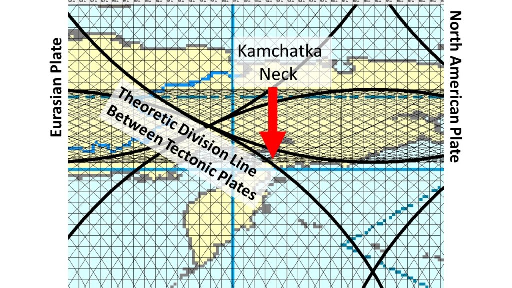
The area of Kamchatka is geologically extremely important, becauase in those areas the North American Tectonic Plate meets the Eaurasian Plate. A main division line of the model used here does cross the peninsulas there.
To introduce the model of convection rolls and how it explains the existence and distribution of geothermal resources in Iceland, I take part in the World Geothermal Congress held in Reykjavik this year (2021). The model should better have been developed in the nineteenth century when it was realized that land mass is regularly distributed along equator, and that must be for a reason. Someone should have considered that the span of the Atlantic Ocean and the Indian Ocean of 60° represented two large convecction cells, and the mainland of S-America, Africa and Indonesia span 30°, did show the location of a single large scale convection cell underneath. But no one did, so this became a debate finding place within the twentyfirst century! Harry Hess https://en.wikipedia.org/wiki/Harry_Hammond_Hess was on the correct track in 1962 with the article ´History of Ocean Basins´. Further development effort by the scientific community of his theory would have made this website obsolete. But my video about geothermal resources is found here, meant to bring us all one step closer to the ‘correct track’ again: https://wgc2020-virtual2.velkomin.is/login?redirect=/event/13040
Realizing that convection takes place within the mantle is easy and acknowledged by virtually everyone engaged in geoscience. The convection pattern, on the other hand, was a bit hard to derive. Now it has all been clarified and shown to everyone. The starting point is obvious enough to be 100% convincing, namely the fact that convection rolls with height to width ration 1:1 clearly fit exactly within the equatorial plane. The rest has to be found out, step by step, with the help of some knowledge about physics. You have to consider that the Earth rotates, that the mantle convects, and the constraints resulting from the geoid shape. Then you find out the exact dimensions, shape and location of the convection rolls within the Earth.
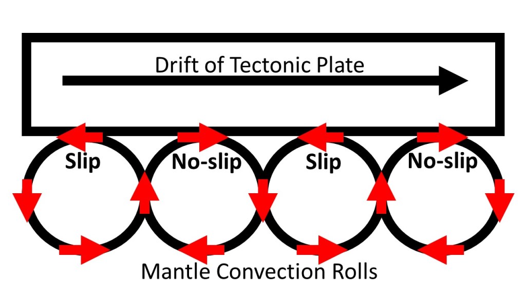
Tectonic drift has to be powered with convection currents. The currents do not work against each other due to slip and no-slip conditions. When a tectonic plate has started drifting into a certain directions, those convection rolls rolling with it also connect with it firmly, but those rolling the opposite way loose the grip. This is due to the fact that the mantle is very close to melting point, so extra friction causes melting, but less friction causes solidation.
Slip and No-slip resulting in tectonic drift.
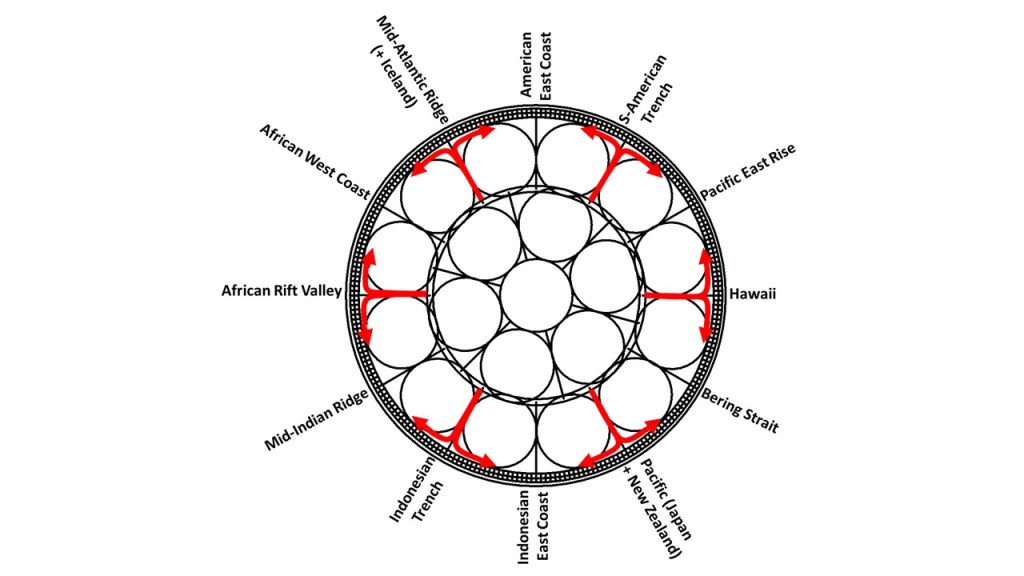
The large scale and small scale convection rolls then work together according to this picture:
Main points of main convection rolls division lines.
The small convection rolls found below the tectonic rolls therefore play a big role in inducing the tectonic drift.
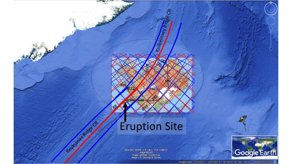
We relate the Reykjanes Peninsula to the Reykjanes Ridge. It is so obvious that the peninsula is a continuation of this part of the huge Mid-Ocean Ridge of the Atlantic. But looking below the crust, things become somewhat different. The convection rolls of Reykjanes are subducted by the Kolbeinsey Ridge Convection Rolls, and therefore the magma now flowing as lava at Fagradalsfjall is not the same as that of the main part of the Reykjanes Ridge.
SS
The subduction can be shown graphically as here below:
The two systems of convection rolls intersect between 60.7°N and 67.3°N, and the northern rolls are found over the southern ones.
The dike of the eruption site of Fagradalsfjall makes a turn that must be explained. The magma found its way from the vicinity of Keilir and propagated SW towards Fagradalsfjall. Then it made a turn directly south, just to make a turn again farther south in the same direction as before. All this is in harmony with the magical shape of Fagradalsfjall. It is actually diamond-shaped, about 3.5 kilometers on each side. The deviation from north is the same for all sides, and the alignment is accurately the calculated value for convection rolls.
The dike of Fagradalsfjall, responsible for Geldingadalir eruption. Map from the University of Iceland inserted, showing the predicted dike location.
The mountain clearly has a NS-axis, and almost as clearly an EW-axis, although the westernmost corner is missing. The sides have the same alignment as the dike, and it makes a turn apparently where it meets with the EW-axis of the mountain. The NS-direction of the dike can be explained with the existence of NS-oriented earthquake faults in the area. Farther south, the dike again propagates along the SE-side of the mountain, as large faults are found there aligned NE-SW.