Blog

Uncategorized

Tectonic drift of N-America and Eurasia – the new findings with GPS

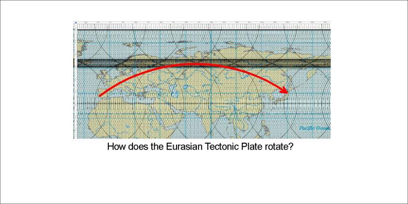
Before we thought about the plates of N-America and Europe as splitting apart. Now we know more, namely that they rotate in opposite directions. Finding it out is not enough, though. We have to learn it.

Samsett mynd - landrek - 01

Please compare this with actual data, for instance of Landmælingar Íslands and NASA.

Also note the two vectors from Iceland. The vectors found in NW and NE of the country are symmetric around NS-axis (same deviation from North). It shows the role of the main mantle division line drawn on the basic map. These vectors are parallel to the rotation found farther to the south on the two continents.

The speed of the tectonic drift in Iceland is close to 2.5 cm a year, oriented towards NE and NW. It is faster than previously thought, when only the division rate of a little less than 1 cm a year for each plate was measured.

Uncategorized

Rotation of the Eurasian Tectonic Plate

NASA website shows the accurate data. Generalizing the vectors showing the drift, we get a picture like this (please compare with the proper measurements):

Eurasia

This is quite in harmony with the opposite rotation of North America. The radius of rotation is considerably larger, as the Eurasian Continent spans 150° along the 51st parallel, but North America spans over only 60° at the same latitude.

This provides a base to analyze the tectonic drift further. Scientists can pinpoint the rotation points etc.

Uncategorized

Rotation of the North American Continent

North America rotates anti-clockwise away from the Mid-Atlantic Ridge towards the Pacific Plate. It is constantly displayed by NASA. The drift vectors are in harmony with the convection cells and mantle currents within the globe. Comparing with real data, an approximation for the drift can be made:

North America Rotation - approximate

In this way (please compare with data at the NASA website) we can see the present situation, and predict how the continent will move relative to the main lines. Especially, former position of main points of the convection cell system can be traced, explaining geological features in those areas in context with other circumstances during those times.


Uncategorized

Why is North America divided so drastically into East and West?

The United States of America are divided into two parts. So can we explain that further? Let us draw a NS-axis accurately in the middle.

The central line of NA

The contrast becomes clear with a single line. But the upper horizontal line is important. It spans exactly 60°. And the two corners are those of two hubs of the convection cell system. So here is the position of the USA:

US symmetry compared with convection lines

The path of the convection lines forms hubs where upper and lower cells meet with each other. So the coasts are actually found to lean to those two points. Just to show how detailed this marvelous coherence between the continent of America and the convection cells underneath is, have a look at this map:

US symmetry convection lines

This is how the North American continent is divided into two, or perhaps a few, parts.

Probably someone does not understand the meaning of the lines drawn. The basics: A pair of parallel lines shows the location of one convection roll. There are two layers of convection rolls between 120-410 km depth. Below that, there are large convection rolls, marked with wider lines.

Uncategorized

Everyone can see Ninetyeast Ridge on a World Map, but how to explain it?

Looking at a World Map, a long ridge does decorate the Indian Ocean, called the Ninetyeast Ridge. It simply lies close to 90°E. It is not the only NS feature in the area, because the Chagos Trench is found west of it, forming a parallel. And there is a mystery:

Ninetyeast Ridge

This square is surprisingly regular, besides that the interval between Ninetyeast and Chagos along equator spans 15°. That is half the width of a large convection cell in lower mantle… So why is that? Actually we need one more step of investigation to understand a bit what is going on. There are more NS faults found east of the Ninetyeast Ridge, so they seem to be a part of the same piece in the puzzle.

The Indian Ocean floor Indian Ocean floor drifts to NE, a direction that does not seem to have anything in common with NS. Still, at equator the main division point between convection cells is found at the coast of Sumatra. Therefore this NS framework can be considered as spanning 30° along equator and showing its effect directly southwards due to NS symmetry of the convection currents.

Indian Ocean - East

This is therefore the holistic piece. The Central Indian Ridge forms the western edge of the framework. The eastern most suspicious NS lines are found extending from the division point of Sumatra coast of the equator line.

The equator plane is essential for the convection cell system. Therefore I add the division points map here:

World at equator - 01

Finally, to get a bird’s eye view of the surroundings of Ninetyeast Ridge and the relevant square, let us compare it with the convection cell division line main pattern:

World - Ninetyeast Ridge

This is the square, spanning 30° along equator.