Blog

Uncategorized

The Geometry of China

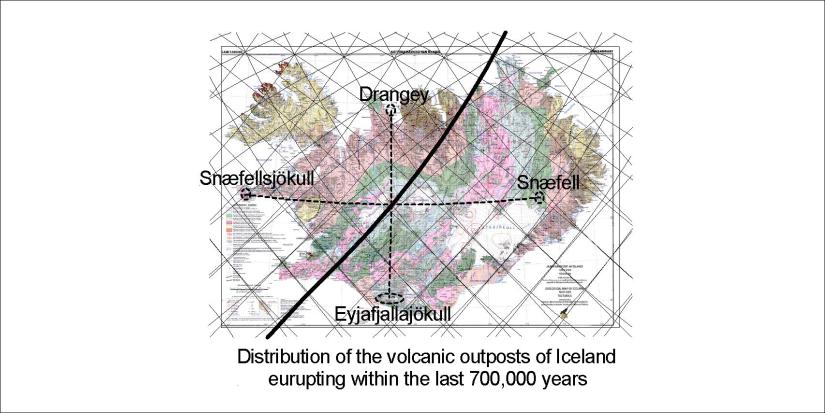
China is very large and has a double nature, namely the Eastern and the Western parts. The division can be compared to the convection rolls, taking tectonic drift direction into account. The intersection between two circular zones divides China into two totally different parts. The border between China and India/Nepal is shaped exactly like the coastline of China. The amazing result is that most of Chinese territory is found within two circular effect zones with exactly the same radius, intersecting each other.

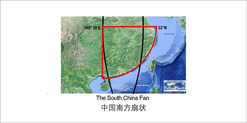
中国领土主要分两部分,东部和西部。这两个地区可以用两个圆圈来画出来,而东部圆圈的直径位于北纬32°。显出东部和西部两个圆圈直径是一样的。中国东部的北方和南方也可以这样分明,因为长江也接壤北纬32°。

Geometry of China

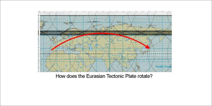
To fully understand this you must take all the Eurasian Plate into account.

Eurasia

Resulting in this simple drawing:

South China Fan

Please compare and find out more.


Uncategorized

The South China Fan

China, like other areas, has been gradually shaped by the tectonic drift of the continents. But at every moment in Earth’s history it is possible to compare the surface with the magma currents underneath. China has been formed in a particular way, and referring to the convection cell pattern it can be clarified further.

South China Fan

The perfectly circular shape of the SE coast of China is centered at the main division line of convection cells, exactly at 32°N where the mantle rolls are oriented NS.


Uncategorized

The framework of Iceland’s southern volcanoes

Katla and Eyjafjallajökull are the southernmost volcanoes, except for the Westman Islands. The framework extending from Hekla to Katla, along with Eyjafallajökull and Torfajökull exhibit the main tectonic fault directions. Usually we emphasize on the alignment of the Eastern Volcanic Zone in general (to the NE), but a simplified drawing of the polygons formed by the convection rolls look like that:

Southern Volcanoes 01

What is specially pointed out here is the connection of Katla with Torfajökull. The light coloured area shows two different alignments, originated from the NS-axis of the polygon. The NW trending faults are mirrored against the NE faults, having the same deviation from North, in opposite directions. The Torfajökull area is in a way confined south of the EW central polygon axis.

This interplay of EW-NE-NS-ES factors and even combinations of these have to be screened to understand the tectonics and distribution of volcanic sites. As previously mentioned, Hekla itself is askew with the system, but it can also be easily calculated like the rest of the southern features.

Uncategorized

Katla – the invisible volcano

Katla is a mystery, because no one has seen the volcano. Now we can detect it easily with modern technology through the ice sheet of Mýrdalsjökull, but somehow it remains obscure.

The division lines between convection rolls crossing below the mountain are marked on the map below. The black line is a downwelling line of the upper most layer, and the red line is upwelling line of the second layer.

Katla 01

Many of the most famous active areas in Iceland are found along these lines. That is in accordance with the activity of Katla – surprising everyone each time it erupts.

Uncategorized

Drangey, the overlooked volcanic island of Iceland

It is known that Drangey is less than 700,000 years old, because its rocks did form within our period of geomagnetic reversal. The volcanic zone of Drangey did appear at the same time as the Snæfellsnes volcanic zone, but now it is extinct. However, geologically  speaking Drangey and the volcanic zone are rather young formations and can be compared with contemporary active areas. Then we get this picture:

Drangey 01

Note that the dotted lines from the central line (showing the deep mantle division) have exactly the same length. Therefore, the distance from the crater of Eyjafjallajökull to the centre, and from the center to Drangey, are exactly the same, besides being accurately on the same NS-axis. The same applies for Snæfell and Snæfellsjökull along the latitude of 64°48′N . From the same central point, the distance is exactly the same form Snæfell to the said central point as the distance from the center to Snæfellsjökull.

This type of consistency is impossible to achieve, unless reality is involved.

Drangey 02

This is an island of stories and wonders. Please check it out.