Blog

Uncategorized

The mantle currents shaping the Reykjanes Ridge

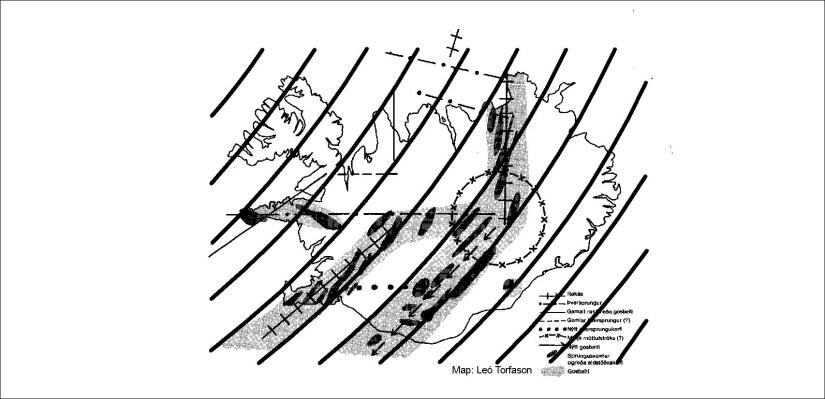
The Reykjanes Ridge is like a long mountain on the sea bottom. It is obviously being pulled to east and west, so convection rolls must be at its sides. The shape can be traced in a mathematical way, and drawn like that:

Reykjaneshryggurinn - rauður

Everyone can trace this and compare with a map, for instance on Google Map, that the red line exactly shows the location of the top of the Reykjanes Ridge. The convection roll between the black line and the red pulls to the east, the other roll pulls to the west.

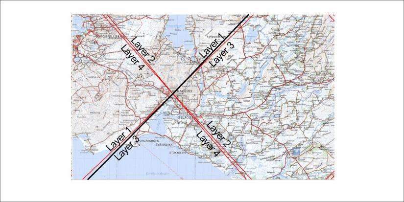
To make the drawing less confusing, let us omit lower rolls, showing clearly the small rolls shaping the Reykjanes Ridge:

Reykjaneshryggurinn - 03

Actually, the main division line of large mantle cells (black line) is not below the Reykjanes Ridge, because the small convection rolls under the tectonic plate at that location are convergent. The divergent convection rolls at the two sides create the Reykjanes Ridge, and then north of 64°N the EVZ appears.

In this way, the tectonics can be understood quickly by comparing to the convection rolls.

Still, in this way you do not have the whole story. Of course, there are more chapters that have to be learned to further analyzing the various complications of relationship between tectonics and mantle currents. This is a section of one chapter out of many 🙂

Uncategorized

Long distance lava flow – how can it happen?

Lava temperature can be around 1250°C on the surface, and just below the tectonic plates around 1500°C. One question is how lava makes its way to the surface? Another is how it can flow as far as it does. The example down below is 140 km. How can that happen?

Þjórsárhraun

This sign is found in the town of Stokkseyri at the south coast of Iceland.

So where does the lava come from? It is originated from the most active rift zone of Iceland, close to where we locate the hot spot. The lava is actually from the volcanic system  Bárðarbunga within the hot spot area.

Þjórsárhraunið

This drawing shows the location of the eruption, right within the main volcanic zone oriented NW-SE. Huge dykes are ofthen created when eruptions like this one occurs, due to the tectonic drift, as the dykes fill up the faults as the land is being pulled apart.


Uncategorized

The convection rolls shaping the volcanic zones of Iceland

Big convection rolls obviously shape the Atlantic Ocean from underneath. Smaller convection rolls are responsible for marking the details of volcanic zones in Iceland. The upper most convection rolls are found side by side as this drawing shows:

Gamla kortið - spjald

The resemblance to this map is quite obvious, as the darkened areas show volcanic zones. The volcanic zones abbrevieated as WVZ and EVZ fit perfectly, along with CVZ and by referring to other convection layers the NVZ and SVZ along with ÖVZ can be explained. Each convection roll spans 1.5° from east to west, swaying according to calculation under the country. The rolls can not be straight, due to the rotation of the Earth and the fact that the mantle is flowing. This layer in particular has a horizontal flow component to the south, swaying slightly to the right as all moving particles have to do on or inside the rotating Earth.

Uncategorized

Mantle division in SW-Iceland: How accurately can it be pinpointed?

The difference between division line between plates and convection rolls can be understood quite easily in the south of Iceland.

Þorlákshöfn-Hveragerði

The central point east of Hveragerði is one of the most appearent in the world, because the N-American and Eurasian plates meet there.

The main division line of lower mantle is oriented SW-NE. The lines between the upper most four layers form an “X”, due to the coincidence that the division lines all meet at 64°N.

Middle - explanation

Each line stands for one of the four convection rolls layers found between 120-410 kilometers deapth. Besides that, the lower mantle cells meet below the black line. For those new to this subject (that is everyone), the intersection zone adds some level of complexity. Everywhere else than at these latitudes, only two layers of upper more convection rolls are found, and only a single set of lower mantle convection rolls. North of 64°N, the layer 1 convection cells have a stronger effect than layer 3. The rolls of layer 1 only reach south to 60.7°N, so south of there layer 3 becomes the upper most layer. At 64°N the thickness of all layers is equal, but north of there layer 1 is thicker than layer 3 and becomes more dominant.