Blog

Uncategorized

66°N symmetry – Iceland – Greenland – Norway

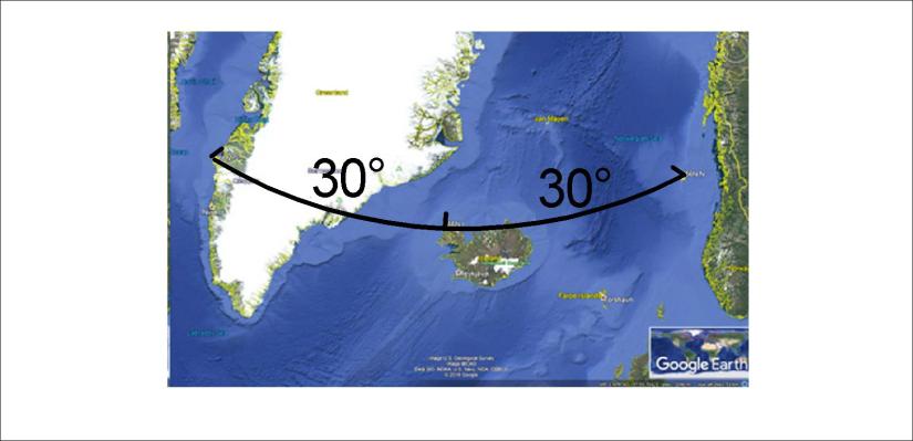
As tectonic drift is due to the flow of magma, the pattern of magma flow affects the arrangement of tectonic plates. A manifestation of such arrangement is found along the latitude of 66°N. There are exactly 30° in between the west coast of Iceland and the west coast of Greenland along that latitude. Also, from the Icelandic coast to the abyss of Norway there are also 30° along 66°N.

Greenland-Iceland-Norwegian Basin at 66N

Coincidence? Sorry, no way! Not to be understood? Not acceptable, because we are obliged to understand things like that, screaming and kicking!

Looking a bit more carefully, you will see that there are 6° along 66°N from the Norwegian abyss to the Norwegian coast. Also, from the west coast point of Iceland, there are exactly 6° to the central magma division line of lower mantle. That logically means that from the central line to the coast of Norway along 66°N there ara exactly 30°. That means the coast of Norway at that point is directly above the main division line of large lower mantle cells (as each of them spans 30° from east to west).

One out of endless mysteries of magic magma!


Uncategorized

The Mid-Atlantic Ridge zik zak

The Mid-Atlantic Ridge sways rather regularly throughout the N-Atlantic sea bottom. The two large convection rolls which must be found at each side of it, can not make jumps or sway irregularly, becuse it is composed of flowing mantle. It must therefore be shaped according to the Earth’s radius and in coherence with the rotation of the Earth.

Mid-Atlantic Ridge - the zikzak

The crossing between mantle division line of the large cells and the Mid-Atlantic Ridge is found at 32°N, which is where the mantle rolls division line is exactly oriented NS.

The magma flow therefore tends to find its way west of the central line in southern latitudes, but east of it north of 32°N. Then it follows the middle line closely along the Reykjanes Ridge, following the next upwelling line east of the main line.

Again, at equator, the two lines merge into one.


Uncategorized

Following the grid, understanding the geology of Iceland – and the World

The map shows it all 🙂 The volcanic sites in Iceland are arranged in a systematic way. First, the Reykjanes Ridge is found along a calculated line extending through the middle of the Atlantic Ocean, with a starting point at equator exactly 30° awy from the coast of S-America on one side and 30° from the coast of Africa on the other side. Then the grid shows how the tectonic plates meet in Iceland. One aspect is the NS-axis from Öræfajökull to Öxarfjörður. Then the Tjörnes Zone in the North shows very clearly the function of the polygon system over Iceland.

Following the grid

It can not be more clearly manifested. Explaining in this way the geology of Iceland makes it easier for comprehend the volcanism, geothermal activity and the geological history of Iceland. With the mechanism in mind, and when everything can be calculated mathematically, it becomes easier to trace changes back in time.