The Coast of Norway follows the edge of a mantle convection roll. This can be seen on this map:
Theoretical Location of the Coast of Norway, as Compared with the Convection Rolls Model of the Earth. Each Circle Marks a Section of a Convection Roll
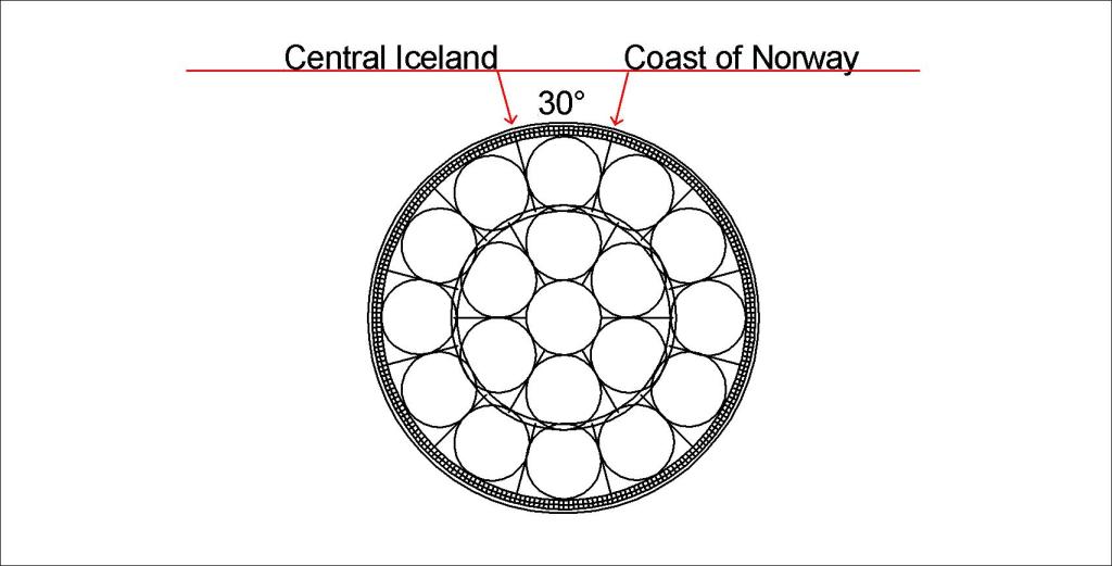
The span from central Iceland to coastal Norway is 30°, the same as the span of a convection roll of the lower mantle. According to GPS measurements, Norway is drifting along this division line. This can be roughly explained with this drawing:
Coast of Norway Compared with Convection Rolls of Lower Mantle (not to scale)
The wide black line along the coast of Norway shows the division line between the large convection rolls.
Question: Why are the convection rolls in the upper picture round, the lower has elongated rolls?
Answer: Because the upper one shows a slice along the latitude 64°N, whlie the lower indicates the vertical section compared with surface (convection rolls perpendicular to surface plane).
As the Reykjanes Ridge follows a mathematical formula, just follow the mathematics. On the surface, a shift is found eastwards for the volcanic activity, in the form of the volcanic zones of Iceland. But underneath, the effect of the Reykjanes Ridge convection rolls is felt.
Reykjanes Ridge Convection Rolls Alignment
These convection rolls become subducted south of Iceland, but still their existence is felt all the way to the surface within the context of the convection rolls system. It is curious that at one point, the same distance is found to the edges of the Icelandic Platform in the ocean, to the North and South, and East and West, respectively.
The main sites of the edge of the East Volcanic Zone are distiributed quite regularly. Here is why:
Katla – Laki – Grímsvötn – Kverkfjöll
The line is actually down-welling, marking the eastern edge of the East Volcanic Zone, which is also a rift zone. When marking the line between the N-American and Eurasian Tectonic Plates, most scientists would draw a line along the middle of the East Volcanic Zone. With the knowledge about the convection rolls, this line is often chosen to show the division line, because all the rifting is actually due to the pulling effect between the N-American Plate and the convection roll rotating into the other direction.
The up-welling large concection rollls of lower mantle flow towards east and west under Iceland. The division line can be pinpointed. It is not directly under the Reykjanes Ridge, because the upper-most convection cells directly above the line have convergent flow. Therefore, the next division line is up-welling, criating the Reykjanes Ridge. Still, the main convection rolls of lower mantle have a ruling effect on tectonic drift, and many interesting places are found along it, or very close to it, including my hometown, Thorlakshofn.
Main destinations along the lower mantle division line.
From Thorlakshöfn, the montain slope called Hlíð marks the line. Then Hveragerði forms a major hub from the effects of different layers of the mantle, manifested by geothermal area. Then the slope of the western margin of the West Volcanic Zone includes Laugarvatn, anogher geothermal area. Geysir is found slightly east of the line, but still on the line of Hekla and Reykholtsdalur. Then we go farther along the edge of Langjökull Glacier, where the mountain range of Jarlhettur forms the division line on the surface. Then we encounter Hveravellir, an area that is dirctly in between the outposts of Icelandic volcanoes, Snæfellsjökull and Snæfell. Finally, in the northern part of Icealnd the line passes slightly east of Akureyri, the capital of the North. Not far from there, Húsavík, with hot spring areas and faults, marks the last landmark for the division line through Iceland.
Geologists generally are aware of the connection between Reykjanes Ridge and Kolbeinsey Ridge. Here, the relevant convection roll is marked with red line for the up-welling division, and blue line for the down-welling part. By comparing with the exact location of the two ridges, the reason for the connection between them becomes clear.
The Continuity of Reykjanes Ridge and Kolbeinsey Ridge
As latitude and longitude can be easily detected on this map, the consistence between real location and this theoretic alignment can be checked out.
The cnvection roll of Reykjanes Ridge is originally connected at 120 km depth with the tectonic plate, but within the intersection zone it becomes subducted by the polar convection rolls. North of the intersection zone, the convection roll found in between the blue and red lines is also connected with the tectonic plate at 120 km depth, and it is also the upper most roll within the intersection zone.
Kolbeinsey Ridge follows a different path than Reykjanes Ridge, and seems to be a consequence of similar process as creates the volcanic zones of iceland. The Reykjanes Ridge is on the contrary directly related to a single up-welling division line.