Considering the jumps of rift zones over Iceland, and seeing the pace of those ‘jumps’, there seems to be a possibility that another rift zone opened before the ‘first one’.
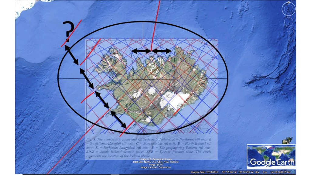
Was there another Rift Axis?
The activity would then have occurred about 25 million years ago, probably at the same time as when the Northwest Rift Axis was active. The prospective rift axis is pointed out with a question mark.
The interval between volcanic zones in Iceland is regular, as shown here:
Map from Árni Hjartarson – The Skagafjörður Volcanic Zone – an ephemeral Rift Zone
As the arrows show, the NE-SW alignment is achieved along the same pattern, namely that of the Reykjanes Ridge. The red lines marking up-welling of convection rolls, fit for all four sets of volcanic zones.
The sequance can be made more clear, by widening the division lines between the upper most convection rolls, found at 120 km depth.
The Jumps of Rift Axis over Iceland
It should also be mentioned, that Öræfajökull is on the fourth line, in accordance with the interval between the up-welling NE-SE aligned division lines between convection rolls.
The so-called ‘jumps’ therefore always occur regularly in the SW of Iceland where the axis is aligned NE-SW. One jump occurs over exactly 3° from east to west along the relevant latitude. The distance between the North Volcanic Zone, and the recently extinct Skagafjörður Volcanic Zone is also 3° at the latitudes of the Tjörnes Fracture Zone. The reason is that each convection roll spans 1.5° from east to west, and a pair of convection rolls, representing one unit in the convection rolls system, spans 3° from east to west.
This can be compared with the results of ISNET measurements by the National Land Survey https://www.lmi.is/
Drift Vectors and Rift Axis ‘Jumps’
The northern component of tectonic drift, in addition to the easterly and westerly components of the vectors is a rather new finding, after GPS was used to measure tectonic drift on global scale. The east and west components had been measured previously. Describing tectonic drift of Iceland, one should say that the western half drifts about 2.5 centimeters a year to the NW, and the eastern half drifts about 2 cm a year to the NE. As a consequence, the country widens up from the middle rift areas by about 2 cm a year, 1 cm to the east and 1 cm to the west.
Volcanic Fissures in South Iceland are generally oriented NE-SW, but in North Iceland they are aligned more NS. The reason is that in South Iceland large polygons lead to pulling effect NW and SE, whereas the more complicated pattern in North Iceland leads to pulling to the East and West.
Shift Zone from NE-SW alingment to NS alingment
Most of SVB (Snæfellsnes Volcanic Belt) is aligned along the zone, covering two convection rolls. The WVZ (West Volcanic Zone) turns in the same way as the MIB (Mid Iceland Belt) within the zone, and the EVZ (East Volcanic Zone) and NVZ (North Volcanic Zone) meet within the zone, showing abrupt shift from NE-SW alignment to NS oriented fissures. The Öræfajökull Volcanic Belt covers two convection rolls, ending with Snæfell Volcano, at the southern border line of the shift zone.
It is also curios that the lower yellow line, is found along Hveravellir, equadistant from Snæfellsjökull and Snæfell, also found on that latitude. Those two volcanoes both mark the end points of the peripheral volcanic zones of SVB and ÖVB. Difectly north of Hveravellir is the extinct SKVB (Skagafjörður Volcanic Belt), and directly south of Hveravellir are Hekla and Eyjafjallajökull, all found on a NS-axis. Therefore, the Shift Zone Line also plays a decisive role in the overall symmetry of the distribution of the volcanic zones.
The earthquake faults of North and South of Iceland generally move in opposite ways. It is easily explained. Here it is put into the context of convection rolls system.
Rotation of Seismic Areas
The South Iceland Seismic Zone is easily detected, with mainly right lateral faults. In West Iceland, a much weaker seismic zone follows the same principle. In the North, the circumstances seem to be more complex, but the effect is the same, except that the rotation effect is oppositte and the faults become mainly left lateral.
The Borgarfjörður Zone in the West is strikingly similar to SISZ, but less active, as it is within the North Americal Plate already, and is only affected by local factors. In the North, the epicenter are found to be distributed along NW-aligned lines, forming blocks of a few polygons. The faults found there tend to be perpendicular to these blocks.
The two ridges north and south of the country are connected with seismic and volcanic zones of Iceland in a similar way.
The Connections between Ridges and Seismic Zones
The Kolbeinsey Ridge connection framework seems to be more complex than that of the Reykjanes Ridge. Grímsey Oblique Rift forms a similar mixture of seismic and volcanic zone, bending and conncecting with the Kolbeinsey Ridge. But the Húsavík-Flatey Fault also connects with a southern extension of the Kolbeinsey Ridge. The Skagafjörður Seismic Area connects the extinct volcanic rift zone of Skagafjörður with the Kolbeinsey Ridge from the western side. The black arrows show the local tension due to the effect of the small convection rolls found below the tectonic plate at 120 km depth. The relevant red division line between those convection rolls is made slightly more prominent than the other lines of the convection rolls division lines grid.