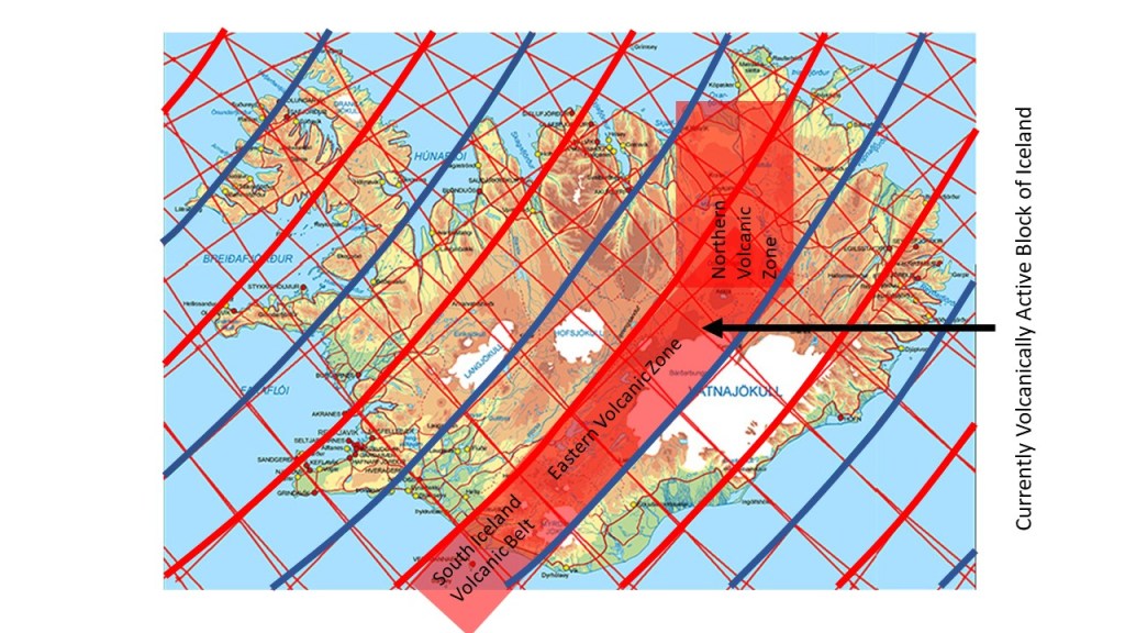
For the last centuries, all volcanic eruptions in Iceland have occurred along a continuous belt. The Eastern Volcanic Zone has the width of 1.5` from east to west.
Currently active volcanic block of Iceland
The reason, as anticipated here, is that the small scale mantle convection roll found at 120 km depth rotates excerts force from west to east on the tectonic plate. At the same time the area is pulled by the North American Tectonic Plate eastwards. These opposite forces create the rift zones and volcanic systems.
Volcanic eruptions will start in the other volcanic zones one day, and intrusions have recently been noticed on Reykjanes Peninsula and within Öraefajökull Volcano. One small eruption occurred in the ocean out of Reykjanes in 1926, as can be seen on the list of this webpage: https://en.vedur.is/earthquakes-and-volcanism/articles/nr/1874.
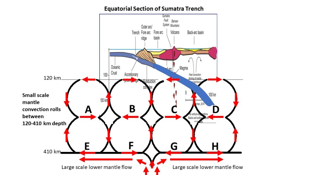
The trenches of oceanic crust interact with the convecting mantle. At Sumatra the pattern looks like this (viewed from south):
Sumatra Trench with convection rolls. Superimposed on drawing from Wikipedia.The real convection rolls location along equator shown on Google Earth Map
The oceanic crust starts bending over the division line between rolls A and B. The crust bends. The outer arc forms over B. The oceanic crust material is then further subducted and enters the down-welling part of convection roll C, and enters the up-welling part between C and D, ending down below the volcano.
Between C and D, geoscientists have already found out that up-welling convection must be taking place underneath the back-arc basin.
This is not a scientific report, as the section is not to scale and no relevant measurements have been made. It is the methodology of comparing convection currents with surface features that is important.
The large scale convection does fix the point between F and G very accurately. The convection rolls have to be of equal height and width (Rayleigh-Bénard convection). The arrangement of the rolls is therefore not disturbed by the interaction between oceanic crust and rolls C and D.
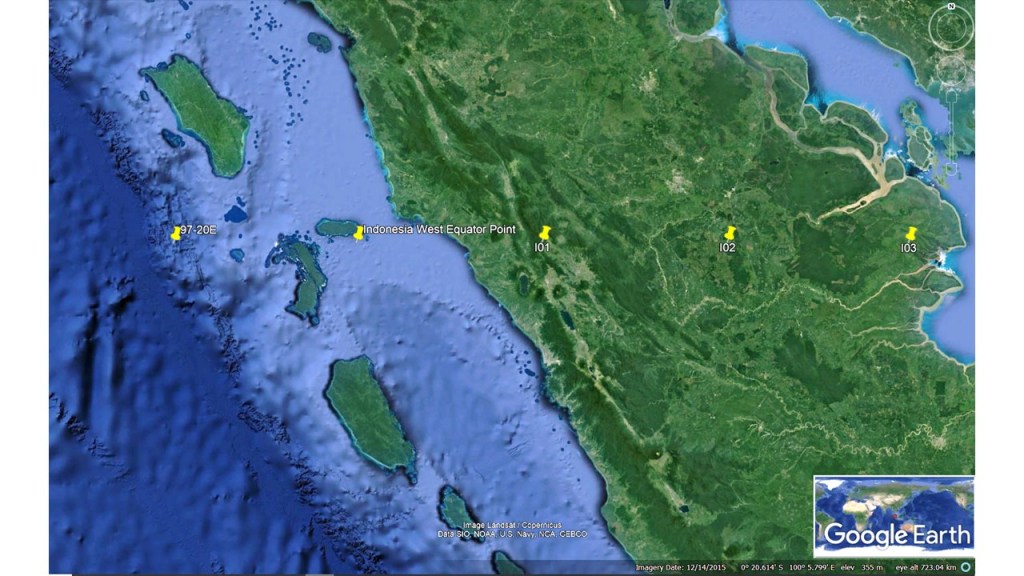
Along equator, the distance between the Central Indian Ridge and the Sumatra Trench, is exactly 30°. According to the analyzis here, both ridge and trench are offset by 1.5° to the west compared with the large scale roll of lower mantle. Therefore, the distance is exactly the expected value compared with the convection rolls model.
The distance between Central Indian Ridge and the Sumatra Trench along equator spans exactly 30°
The Central Indian Ridge is posistioned exactly in the same way as the Reykjanes Ridge compared with the large scale lower mantle rolls division line. The two layers of small scale convection rolls create a down-welling division line exactly above the large scale division, so therefore the ridges tend to appear along the next small scale division line, unavoidably being an up-welling one.
The Sumatra Trench is on 97° 20.000’E, and the Central Indian Ridge on 67° 20.000’E on equator.
The NS-axis of the Icelandic Plateau includes Hekla and Eyjafjallajökull. Around that axis, symmetry if found for the Greenland-Iceland Ridge and the Iceland-Faroe Ridge respectively. The eastern and western outposts of Icelandic volcanoes are found equadistant from the NS-axis, and that point (marked here with ´R´) is where the division line between the large scale lower mantle convection rolls cross the NS-axis. The volcanoes are marked with ‘S’ (Snaefellsjökull) and ´T´(Snaefell). The line S-T-R also marks the turn of basic tectonic alignment from being north-easterly to northerly. The famous volcanoes of Hekla (U) and Eyjafjallajökull (V) are found on the NS-axis. All this symmetry is astonishing, and studying it can make it easier for us to understand the forces behind volcanic activity and tectonic drift.
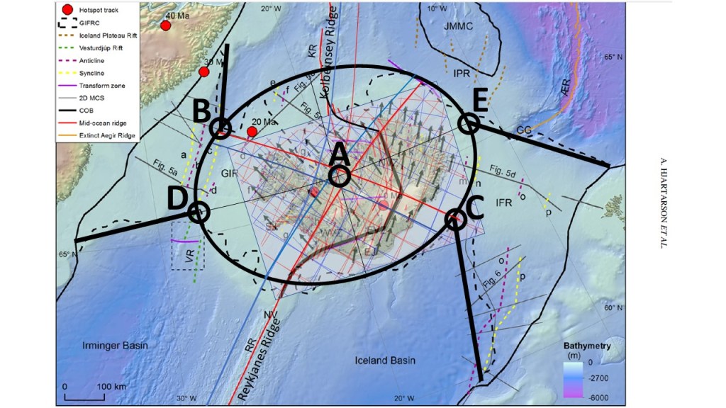
The ridges around Iceland marked on a Google Earth Map.
The symmetry of the two ridges of Greenland-Iceland and Iceland-Faroe has already been explained. (See last post here.) Point A on the NS-axis is equadistant, firstly from B and C, and secondly from D and E. Note that D and E are found on the same latitude. The double symmetry around the NS-axis, for the volcanic outposts on land, and for the elliptical form of the Iceland Plateau, and for the two ridges over to Greenland ane the Faroe Islands, is quite spectacular. As previously mentioned, the same system shows the resemblance between Reykjanes Ridge and Kolbeinsey Ridge.
The information about the ridges around Iceland is based on the article ´The Greenland–Iceland–Faroe Ridge Complex´ https://sp.lyellcollection.org/content/447/1/127 by Hjartarson, Erlendsson and Blischke.
The ridges connecting the Icelandic Plateau with Greenland and the Faroe Islands are equidistant from a single point in central Iceland. This can be seen in the map below:
The equidistant points of the Greenland–Iceland Ridge (GIR) and the Iceland–Faroe Ridge (IFR) compared with central Iceland
On the base map, the elliptical outline of the Icelandic Plateau has been added, with its central point marked as A. The locations where the Greenland–Iceland Ridge and the Iceland–Faroe Ridge meet the ellipse are marked as B and C; both lie at equal distances from point A. Similarly, points D and E, defined along the ellipse, are also equidistant from A.
When the bathymetric extensions of the Reykjanes Ridge and the Kolbeinsey Ridge are traced, they also converge toward point A. Thus, if we normalize the surrounding topography relative to the elliptical form, all of these ridge systems ultimately meet at a single focal point: A.
It is notable that points D and E lie on the same latitude, while B and C fall along the same meridional division, reinforcing the symmetry of the structure.
The Icelandic abyss appears to have developed gradually into a remarkably precise elliptical form. This ellipse is oriented exactly east–west, with its major axis defining the long dimension of the Icelandic Plateau.
When the outline of the ellipse is compared with surrounding ridge systems, the symmetry is striking. The Greenland–Iceland Ridge and the Iceland–Faroe Ridge both coincide with the ends of the major axis. The other two margins align with features that reflect mirrored convection rolls relative to those of the Reykjanes Ridge. In other words, the abyssal form not only echoes the geometry of the connecting ridges but also mirrors the mantle dynamics that created them.
Eliminating the strong bathymetric influence of the Reykjanes Ridge and the Kolbeinsey Ridge, the elliptical outline becomes nearly perfect. Yet this geometric precision has largely gone unnoticed, perhaps because attention has traditionally been focused on local volcanic and tectonic features rather than the broader structural form of the abyss.
The symmetry becomes even more compelling when viewed along the central meridional division through point A, the ellipse’s geometric center. This line passes directly through the craters of Hekla and Eyjafjallajökull — arguably Iceland’s two most famous volcanoes. Moreover, if the axes of the Reykjanes Ridge and the Kolbeinsey Ridge are extrapolated inland from the seafloor, both converge at point A as well.
Such a degree of geometric and geodynamic coincidence is unlikely to be accidental. It suggests that the Icelandic abyss represents not only a surface plateau but also the expression of deeper, organized mantle flow. Explaining why this elliptical form has persisted — and why it has been overlooked — remains an important challenge for understanding Iceland’s unique geodynamic setting.