Uncategorized

The Volcanic Zones of Iceland Explained

The volcanic zones of Iceland are the key to geology. A list is found in the newly published book, Náttúruvá á Íslandi:

Here the 7 volcanic zones are shown, names in Icelandic.

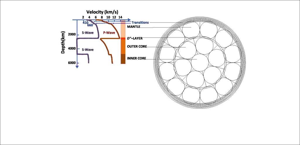
When this is compared with the convection rolls model, a theoretic pattern does emerge:

The volcanic zones of Iceland

A: The Snæfellsnes Volcanic Belt is basicly found end to end of two polygons, passing through the third, similarly as B and H.

B: The Reykjanes Volcanic Belt is based on one polygon, but the second part extending out to the ocean forms a continuity, so it resembles A and H.

C: The West Volcanic Zone covers two polygons in a similar way as F, but on most maps it does not fully cover the polygons from east to west. It then turns north around 65°N, coming to an end rather abruptly.

D: The Mid Iceland Volcanic Zone of Hofsjökull does provide a continuity of volcanic activity from the WVZ (C) to the EVZ (F). According to the system, it should be related to C, as the rifting process should be originated from there. The system is connected to a system added with dotted outlines, marke I, of Skagafjörður.

E: The South Iceland Volcanic Belt is found as a continuation of F, but is not a rift zone, as it does all belong to the Eurasian Tectonic Plate and is presumed to drift with it as a whole. The same type of tension is found theoretically to occur within the two polygons firstly for the one of Eyjafjallajökull and Katla, and secondly for the Vestmannaeyjar Islands polygon.

F: The East Volcanic Zone is the probably most clearly defined of any of the volcanic zones. The west side and east side are accurately marked by the sides of three polygons, extending to the southern part of the fourth polygon of Askja.

G: The North Volcanic Zone is oriented north to south, with volcanic systems arranged in a right hand en echelon pattern. The main polygons form the central axis, but at the sides, a large number of polygons are involved, as in the north, the network of division lines becomes more complex than in the southern half of Iceland.

H: The Öræfajökull Volcanic Belt has been quite obscure due to the fact it is mainly found under the glacier Vatnajökull. It convers two polygons, very much like A and B, extending between Öræfajökull and Snæfell.

I: This is actually an extinct volcanic zone, but as it was active rather recently (less than 800,000 years ago) I want to include it. This is the Skagafjordur Volcanic Belt, responsible for rifting within the fjord for a million years or so, according to Árni Hjartarson who wrote his PhD essay on the topic. The central axis is found exactly 3° west of the central axis of the NVZ (G), which is logical according to the convection rolls system, where similar conditions are repeated every 3° from east to west along each parallel.

The South Icelandic Seismic Zone and a part of the Tjörnes Fracture Zone are marked on the map for reference. The Grímsey Oblique Belt also connects with the Kolbeinsey Ridge north of Iceland, not shown on the maps.

Uncategorized

The Earth’s Layers

The depth of Earth’s layers is known, and the Convection Rolls System was derived accordingly.

Convection Model and Seismic Waves Compared.
Velocity Graph from https://en.wikipedia.org/wiki/Low-velocity_zone

This drawing can be best understood as a section of the equator plane of the Earth. Then all physical factors are combined in a 2D plane. Convection currents of lower mantle and outer core are represented with circles. Real flowlines are of course different, filling up the space of the cell froming the section of a convection roll. Developing a 3D model, the interaction of rotation of the Earth itself (and thereby centrifugal force) and convection currents have to be considered, in addition to the Coriolis effect along with the curvature of the Earth. As all those factors have been taken into account, the Convection Rolls Model has been completed.

Uncategorized

Coast of Norway

The Coast of Norway follows the edge of a mantle convection roll. This can be seen on this map:

Theoretical Location of the Coast of Norway, as Compared with the Convection Rolls Model of the Earth. Each Circle Marks a Section of a Convection Roll

The span from central Iceland to coastal Norway is 30°, the same as the span of a convection roll of the lower mantle. According to GPS measurements, Norway is drifting along this division line. This can be roughly explained with this drawing:

Coast of Norway Compared with Convection Rolls of Lower Mantle (not to scale)

The wide black line along the coast of Norway shows the division line between the large convection rolls.

Question: Why are the convection rolls in the upper picture round, the lower has elongated rolls?

Answer: Because the upper one shows a slice along the latitude 64°N, whlie the lower indicates the vertical section compared with surface (convection rolls perpendicular to surface plane).

Uncategorized

Reykjanes Ridge Prolonged

As the Reykjanes Ridge follows a mathematical formula, just follow the mathematics. On the surface, a shift is found eastwards for the volcanic activity, in the form of the volcanic zones of Iceland. But underneath, the effect of the Reykjanes Ridge convection rolls is felt.

Reykjanes Ridge Convection Rolls Alignment

These convection rolls become subducted south of Iceland, but still their existence is felt all the way to the surface within the context of the convection rolls system. It is curious that at one point, the same distance is found to the edges of the Icelandic Platform in the ocean, to the North and South, and East and West, respectively.

Uncategorized

Katla – Laki – Grímsvötn – Kverkfjöll

The main sites of the edge of the East Volcanic Zone are distiributed quite regularly. Here is why:

Katla – Laki – Grímsvötn – Kverkfjöll

The line is actually down-welling, marking the eastern edge of the East Volcanic Zone, which is also a rift zone. When marking the line between the N-American and Eurasian Tectonic Plates, most scientists would draw a line along the middle of the East Volcanic Zone. With the knowledge about the convection rolls, this line is often chosen to show the division line, because all the rifting is actually due to the pulling effect between the N-American Plate and the convection roll rotating into the other direction.