Uncategorized

Indonesia Along Equator

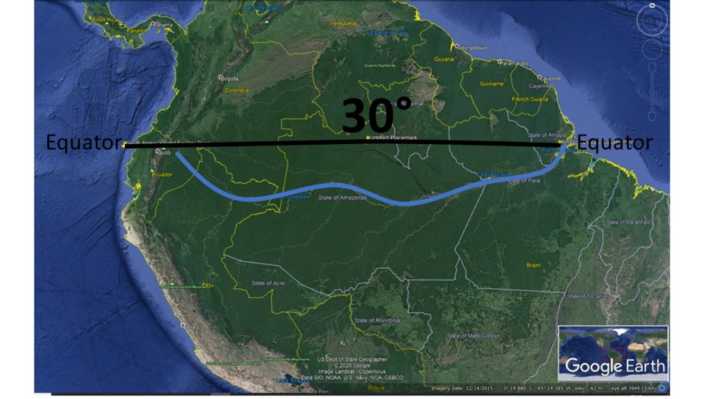
Another example of how the topography follows the division lines of convection rolls along equator is Indonesia. It spans 30° from east to west, just like South America. Also, the two points of east and west have exactly the correct position as compared to S-America. We find steps of 30° around the world!

Indonesia along equator line spans 30° from east to west

So this pattern is obvious. The up-welling line is found at the western point of the 30° string, extending farther to the south where you find Krakatoa, one of the most famous volcanoes in the world. Therefore, behind the trench and relevant geology, there are geophysical preconditions we should look into.

Equator Plane with S-America and Indonesia

The string length along equator over S-America and Indonesia is exactly the same. Both span 30° out of the 360° of the whole of equator. Besides that, the two strings are found exactly opposite to each other as shown in the drawing above. It should be enough just to point this out, so everyone can see that this can be no coincidence. This distribution is also consistent with the convection rolls model, with the width of the convection rolls underneath being the same as the height. By noticing this, we add to our possibilities to understand the functions of the Earth, on which we live.

Uncategorized

The Amazon Area of South America

The Amazon basin is aligned predominantly west–east, and the Amazon estuary lies on the Equator. According to the convection-rolls model, this estuary is situated on a major downwelling division line between large lower-mantle convection rolls.

In addition, 30° westward along the Equator from the Amazon estuary lies the west coast of South America, where a deep oceanic trench is present. This trench corresponds to another division line of large scale lower mantle convection rolls associated with the implications of uppermost mantle convection rolls of the asthenosphere.

South America Spans 30° along Equator Line

South America spans roughly 30° of longitude along the Equator, from the Amazon estuary to the Pacific margin. This is followed by an approximately 60° longitudinal span along the Equator across the Atlantic Ocean to Africa (with the Mid-Atlantic Ridge in the middle, and therefore we have two 30° steps across the ocean), and then a further 30° span from the west coast of Africa to the Great Rift Valley. At each of these longitudinal intervals, a division line between major lower-mantle convection rolls can be identified.

The Amazon River, marked approximately by a blue line, closely follows the equatorial parallel and appears to be structurally guided by this deep mantle boundary. This spatial correspondence suggests that large-scale mantle convection geometry exerts a first-order control on continental-scale river systems, plate boundaries, and major tectonic features.

Uncategorized

The SE Edge of Vatnajökull Glacier in Iceland

The SE edge of Vatnajökull is lineray oriented to the NE from Öræfajökull Volcano. This edge is formed by a line of mountains, which ar found above the easternmost up-welling mantle division lines crossing the country in that direction. Geothermal heat is found in the valleys, and the more the glacier retreats, the more has been found.

The SE Edge of Vatnajökull

The calculated division line coincides with the mountains forming the edge of the glacier. It has been found that the number of dikes is high in the area and geothermal activity quite appearent. This up-welling, along the upper most line of 120 km depth, and the third layer as well farther down (below 265 km) is also up-welling, and almost coincides with convection layer 1, adds to the effect.

Vatnajökull: https://www3.uef.fi/documents/640649/725289/NEED+V_New+Geo+Review.pdf/273c6abe-cf05-4c36-92cb-a5cc3fdaf930

Uncategorized

Large Scale Convection Rolls Division Lines for Iceland and Hawaii

Iceland and Hawaii are both located on large scale division lines of lower mantle. That explains the volcanic activity within both areas. This can be found because convection rolls of equal hight and width fit into the layer, and the horizontal curvature of the rolls can be calculated.

Iceland and Hawaii are Found on Up-welling Mantle Convection Rolls Division Lines

The red curved lines show up-welling division between large scale convection rolls, spanning 30° from east to west. The blue curved lines show down-welling division between large scale convection rolls. Iceland and Hawaii are both found on such up-welling lines. This is the most basic feature of the convection rolls system.

Uncategorized

The Convection of Mantle Under Africa – How Does it Work?

The large convection rolls, spanning 30° from east to west, rule the main trend of tectonic drift. But the smaller rolls above, spanning 1.5° from east to west, make it more complicated. The Great Rift Valley of Africa is located above a main division line of up-welling within the lower mantle. At equator, the difference between convergent and divergent small scale rolls can be examined.

The Great Rift Valley of Africa

The red lines show the different points, one local diverging point, one large scale diverging point which is at the same time a local converging point. This seems controversial, but is an inherent factor of the convection rolls system.