I am a geologist, graduated from the University of Iceland, and taught geology for a few years. I have gained some knowledge about Earth's inner structure, so I provide this website as my contribution to answer one of the greatest questions remaining within the realm of geoscience. Experiments show that the mantle should form convection rolls when close to the melting point. I took this literally, and calculated the dimensions and shape of these mantle convection rolls. Then I compare that model with the surface. This makes it possible to provide many interesting examples about geology found on my blog.
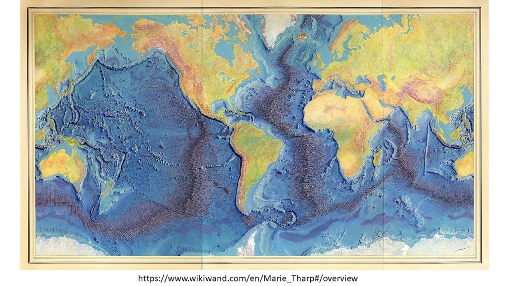
The mid ocean ridges can be compared with the convection rolls system. The original map looks like that:
The Mid Ocean Ridges mapped by Tharp and Heezen
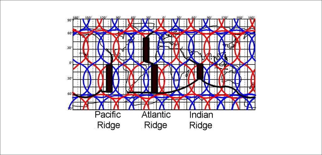
This can be compared with the convection rolls in a simple way:
Simplified Pattern of Mid Ocean Ridges
A more precise analysis, down to the 1.5° accuracy level, reveals much more, as shown for instance for the Reykjanes Ridge, barely noticeable on this World Map. The Reykjanes Ridge follows a division line exactly.
A profound difference is found between the North Atlantic Ridge and the South Atlantic Ridge. The North Atlantic Ridge is found along a up-welling line, but the South Atlantic Ridge is found in between the lines. A pattern of three ridges, for the Pacific, S-Atlantic and Indian Ocean, in harmony with the 30° divisions between convection rolls, appears,
The large Pacific Plate covers several large scale convection rolls, so the reaction to opposite flow of mantle must be understood. The answer is coupling and de-coupling process with the upper-most rolls. Similar process is known at the bottof of glaciers, sliding over un-even ground. The ice melts when meeting with upheavals, then it does freeze at the other end with less fraction, and then ‘plucks’ the rock below. The process of tectonic plate sliding from east to west, is exactly the same with 1.5° interval. Besides that, every 30° some other change generally occurs, due to a different large scale trend associated with the 30° E-W units of lower mantle rolls.
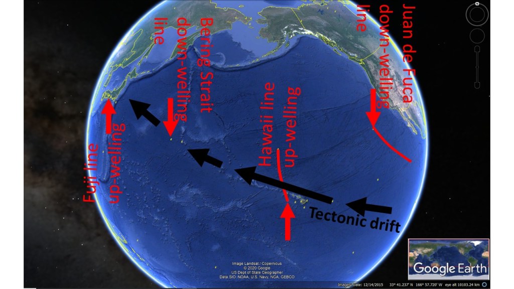
The Drift Direction of Pacific Tectonic Plate
The volcanic activity resulting when the Pacific Tectonic Plate reaches the main division line, or more accurately the 6° interval of small scale upper rolls east of the main line, shows the local trend of inducing opposite tectonic drift to the main drift. Also, a hub of the convection rolls system is found at this location.
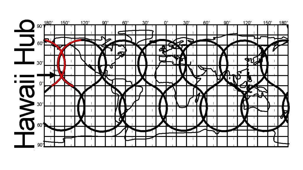
Hawaii Hub of Convection Rolls System of Up-welling Lines
As can be seen, all the up-welling lines are in fact connected into one wholistic system. The Polar Parts are omitted here. The implications of the hub provede an extra pressure/weakness to the area of the Hawaii Islands. Still, do not forget the other factor, horizontal tectonic drift, being opposed east of the red lines of Hawaii.
The 8-formed loops might be difficult to understand at first, as the large scale convection rolls only represent half of that arrangement. The other half of each 8-form is represented on one hand by the small scale rolls found between 265-410 km depth, and on the other hand by the outer core. Traces of core material can therefore be found in magma of countries like Hawaii and Iceland.
The huge Pacific Ocean Plate moves fast westwards, and the reason is flow of mantle material. But how? Many convection rolls participate in moving the plate. The rolls moving in the same direction as the plate must be more coupled to the plate than those opposing the dirft direction. Thereby, the drift can be maintained over this huge distance. The small rolls, spanning 1.5° from east to west are mainly responsible for the direct force applied on the plate, but large scale trend is ruled by the large scale rolls underneath.
This can be shown with a section of the equator plane seen from the north.
The Pacific Rise along equator has, at first sight, an opposite flow direction to the drift direction of the plates, but the Pacific Plate is pulled away by the large section west of it, and the Nazca Plate is then the counterpart drifting to the other direction, namely to the east.
So the Pacific Ocean conceales the system below by not having formed a ridge where Hawaii is located. At first sight, The ridge should have formed there, with a whole plate reaching S-America, and the other half extending to Japan. If it was like that, the system above would have been realised a long, long time ago, when the ocean ridges were first mapped.
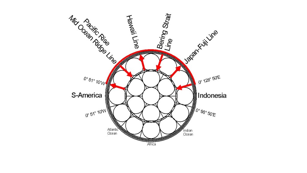
The 30° step pattern along equator has been mentioned here several times. It is more obvious for S-America, Atlantic, Africa and Indonesia. The Pacific Ocean division points are found at other latitudes, but easily comparable, and the starting points of S-America and Indonesia are of course in common with the end points of the ‘coast – 30° – coast – 30° – ocean ridge – 30° – coast – 30° – coast – 30° – ocean ridge – 30° – coast – 30° – coast – 30° pattern’ from S-America to Indonesia.
Convection Rolls in East Pacific Ocean
The down-welling line in the middle is also responsible for Juan de Fuca, so between Hawaii and N-America there is mainly only one convection roll found of 30° from east to west.
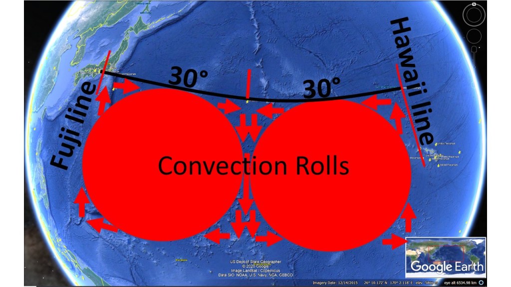
Fuji in Japan and Hawaii have similar relation to the main division lines of lower mantle. Therefore they are found 60° apart, as shown on this drawing:
Japan and Hawaii
Both areas are located on up-welling lines. The main chain of Hawaii spans 30° from east to west, from Hawaii Island itself to the southern end of the Emperor Chain. The background of that turn is therefore more complex than most people think (the common explanation that the tectonic drift just made a turn one day due to changes elsewhere). Today, the Hawaii chain seems to be developing southwards. The drawings of convection rolls represents a vertical section of the rolls. The ridge extending south of Japan is therefore one of the main manifestations showing the location and shape of the convection rolls within the mantle. The detailed analysis has to be made with the map of the upper-most convection rolls, understanding the implications within the volcanic areas of Japan and Hawaii Islands. But with this general section in mind, the exceptional volcanism of Japan and Hawaii becomes much easier to understand. Note that the volcanism in Hawaii has to be explained according to at least two small scale rolls, spanning 2×1.5° from east to west. The volacanism is found where certain conflict is found between the large scale convection roll of Central Pacific and the general tectonic drift direction. Once the sea floor is pulled over to the convection roll west of the volcanic islands, volcanism ceases.
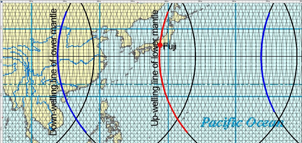
Mt. Fuji in Japan is a symbol of all volcanoes, and is very strategically located on one of the six main up-welling lines of the World.
Fuji is located on up-welling mantle line
The ridge south of Japan follows the line accurately.
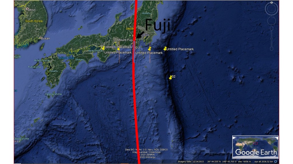
Fuji and the convection rolls division line
This shows that the trench system spans 3° from east to west, beginning with a local down-welling of upper mantle at 120 km depth, and the seafloor seems to be engulfed by the main division line of lower mantle, resulting in shaping the western edge of the ridge, besides Mt. Fuji.
The local upper mantle down-welling line is directly above the large-scale lower mantle up-welling line, resulting in a contraversy between large-scale tectonic drift and local trend.