Uncategorized

Identification of Active Volcanic Polygons in Iceland

Iceland is divided into several volcanic zones and belts. Here, a division method according to numbers of polygons is introduced.

Numbers of volcanically active polygons in Iceland

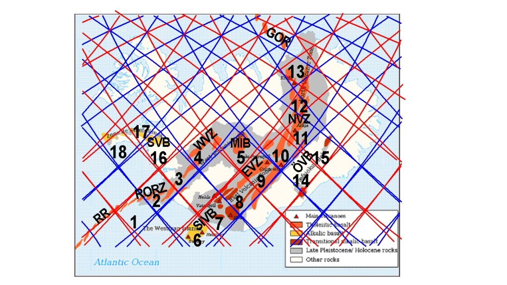
(1) This polygon comprises half of Reykjanes Oblique Rift Zone (RORZ). The western corner connects with the Reykjanes Ridge. (2) The other half of RORZ. The eastern corner connects with the South Iceland Seismic Zone. (3) The southern half of the Western Volcanic Zone. The rifting process is mainly found within the eastern half of the polygon. The Rift Valley of Thingvellir is found there. (4) The northern half of the WVZ. Langjökull Glacier covers a large part of this section. (5) This polygon is a volcanic belt on its own. Formerly, it was the southern end of a much longer volcanic zone extending to Skagafjordur, but that part was replaced by the North Volcanic Zone. (6) The southern part of the South Iceland Volcanic Belt, which contains the Westman Islands. (7) The northern part of the SIVB with Eyjafjallajökull and Katla. Hekla is located on the northern corner of the polygon. (8) The southernmost part of the Eastern Volcanic Zone. The rifting process perpendicular to tectonic drift appears very clearly, and magma is mainly provided horizontally from the adjacent polygons, for instance from Grímsvötn, Bárdarbunga or Katla caldera. (9) The central polygon of the EVZ, filled with powerful volcanic systems. It has adjacent mini polygons of Kverkfjöll and Grímsvötn, and the side system of Tungnafellsjökull. In the middle, Bárdarbunga has played a big role, responsible for the Holuhraun eruption. (11) The southernmost polygon of the North Volcanic Zone. It is actually the turning part between the EVZ and the NVZ, and the pattern forming the polygons becomes less distinct along this latitude. Askja is found in the center of the area. (12) This polygon of Hrúthálsar volcanic site is the central part of NVZ. It is perhaps a bit remote and has not been active recently, so it is not a famous volcanic site. (13) The southern side of the polygon forms a hub for the volcanic and geothermal areas near Lake Mývatn. The northern corner marks the end of the NVZ, It connects with the Grímsey Oblique Rift in the north. (14) This is the southern half of the Öræfajökull Volcanic Belt. It is a bit outside the main volcanic formations of Iceland and is entirely located within the Eurasian Tectonic Plate area. (15) The northern half of the ÖVB, with Snæfell Volcano at the northern end. Snæfell is also curiously a counterpart of Snæfellsjökull in the west of Iceland, found exactly on the same latitude, and in the same context with the mantle convection rolls system (although mirrored). (16) The eastern roots of the Snæfellsnes Volcanic Belt. The Ljósufjöll Volcanic System extends through the area. (17) The central part of SVB, marking the location of Lýsufjöll Volcanic System. (18) The western most part of SVB, with Snæfellsjökull at the western end, being the western outpost of Icelandic Volcanoes, and as mentioned before, the counterpart of the eastern outposts of Icelandic Volcanoes, Snæfell. The Grímsey Oblique Rift has a few volcanic systems, but the polygon system is quite tight at that latitude, so no numbers are given to that area here. The Reykjanes Ridge follows a line, rather than polygons, so it is not included in this numerical system either. Many mini polygons must be analyzed separately but are not included here to maintain some degree of clarity.

Uncategorized

Tectonic Drift Direction and Perpendicular Rifting Process

The Eastern Volcanic Rift Zone is unique and shows the interplay between tectonic drift and rift process. The rifting is perpendicular to the tectonic drift.

The drift vectors ara symmetrical around NS-axis.

The drift in the western half is slightly faster than in the eastern half. The drift vectors tend to be perpendicular to equatorial convection rolls, and thereby the vectors are aligned along the polar convection rolls. Information about the measurements of tectonic drift is found here: https://www.lmi.is/static/files/utgefid_efni/Maelingar/isnet_endurmael_2016_skyrsla.pdf

The rifting perpendicular to basic drift direction results in a row of craters like Lakagígar

This picture is found on a sign in the middle of the Eldhraun Lava Field which did flow in the year 1783.

Uncategorized

Boiling Ground at Mývatn Nature Baths

The Mývatn area is on the plate boundary of North Iceland. In addition, special stress from below is added by mantle currents. Steam leaks from the groun all around the road leading to the Mývatn Nature Baths.

The Mývatn Nature Baths seen in the distance

Exceptional activity as found near Mývatn can be explained, as seen on the map below.

Areas of Mývatn Nature Baths, Bjarnarflag, Krafla, Hverarönd etc.

North-east of Mývatn is a geothermal wonderland, that can only be explained with this line of mantle convection underneath. The line is of double nature, because it both stands for division between small rolls of upper mantle, and also that of the large scale rolls of lower mantle. Mývatn is located directly over the big convection rolls responsible for creating the Atlantic Ocean.

Uncategorized

The Complexity of Reykjanes Oblique Rift Zone

Reykjanes Oblique Rift Zone is one of the most geologically complex areas in Iceland, because it has interwoven volcanic and seismic zone. The strike-slip faults of the seismic zone form due to pressure from SW and NE, whereas the volcanic fissures open when rifting occurs because of pulling from SE and NW. The polygon forming the main part of the Reykjanes Peninsula explains this. Therefore, we can see that different layers of convection rolls can affect the same area simultaneously.

The Reykjanes Oblique Rift Zone Polygon

A map from ISOR has been inserted at the lower right corner to show how the volcanic zones form perpendicular to the drift of the North American Tectonic Plate on one hand, and the opposite small scale effect of the eastern Reykjanes Ridge Convection Roll on the other hand.

The local rifting due to effect of opposite magma flow of the convection current below is found on bothe sides of the division line between N-America and Eurasia, drawn as curved black line through the polygon of Reykjanes Peninsula.

Red lines indicate up-welling division between convection rolls, blue lines are for down-welling.

Uncategorized

The Pattern of Large Fjords in North Iceland

The fjords in North Iceland are rather large and wide. They look at first as randomly distributed with various shape. Comparing with the convection currents underneath, the pattern is not random at all. The convection rolls division line extending from the Reykjanes Ridge marks the three eastern fjords of Eyjafjörður, Skjálfandi and Öxarfjörður. The crossings between that line and the other equator lines of the next layer below mark the estuary of the relevant rivers flowing into the fjords. The next division line north of the Reykjanes Ridge line works in the same way, marking Hrútafjörður, Húnafjörður and Skagafjörður. The result is a ladder-shaped pattern for the fjords, when compared with the mantle convection rolls underneath.

The pattern of large fjords in North Iceland

The two layers forming the surface in this way (with help from the glaciers above during the ice age) are actuallly the subducted convection rolls, at this latitude only found close to 410 km depth. How can the upper rolls be a secondary factor? Actually they also have their say. The lower set of convetion rolls at the north coast seem to have a certain degree of coupling, and therefore the Tjörnes Fracture Zone mainly follows the division lines of those lower layers. In the same way, the lower layers have this effect on large scale formation of topography of the North of Iceland.