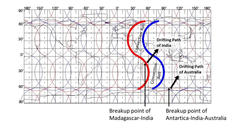
The breakup of Antarctica, India and Australia can be traced accurately, and here we look a bit further into the process. India ‘left’ Madagascar behind on its way towards Eurasia, and the responsible forces down below can be analyzed as shown here:
The breakup of Antarctica, India and Australia
The convection roll forcing India to cross equator is marked specially with wide red and blue lines. After entering the area above the adjacent large scale convection roll, India turns anti-clockwise.
Australia, on the other hand, follows a northern trend within a single convection roll. The eastern edge is confined with a downwelling division line, shaping the mountain range on that side.
The Indo-Australian Plate does therefore move in the same direction. Note that upwelling and downwelling of large-scale convection rolls does not govern tectonic drift directions. The direction is determined much more randomly, and once on the plates move along a certain path, the opposing small-scale convection rolls get decoupled and the pro-active convection rolls tend to get coupled to the tectonic plate bottom. It is easy to see though, that the alignment of convection rolls is a ruling factor for the drift direction of India and Australia for the last 50 Ma.
The lowest point of Earth is found at the Dead Sea, so some particular conditions must be prevalent there. Looking at the mantle convection pattern, some explanations can be made.
North-South alignment of convection rolls within the Mediterranean.
The main division line, as defined here, is actually at the western margin of the Nile Delta. This particular main division line, marked with slightly wider red line than the others, is not of a single origin, according to the convection rolls model. First, it is a main division line of the convection rolls of the outer core. Second, it is a division line of the lower set of convection rolls found between 265-410 km depth. The rolls of the upper set (between 120-265 km) and the lower set interact, as the division lines almost coincide at these latitudes.
The Nile is kept in an incredible way on its northwards path with this system, and the main part of the delta is found in between two cooperating downwelling lines. Farther to the east, this combination of convection rolls marks the beginning of the Great Rift Valley system with the Dead Sea fault line. As can be seen, the relevant upwelling division line is quite parallel to the Dead Sea fault, but is found slightly west of it, except at the intersection point of the upper and lower convection rolls, where the rift system shifts to the west of the convection rolls division lines.
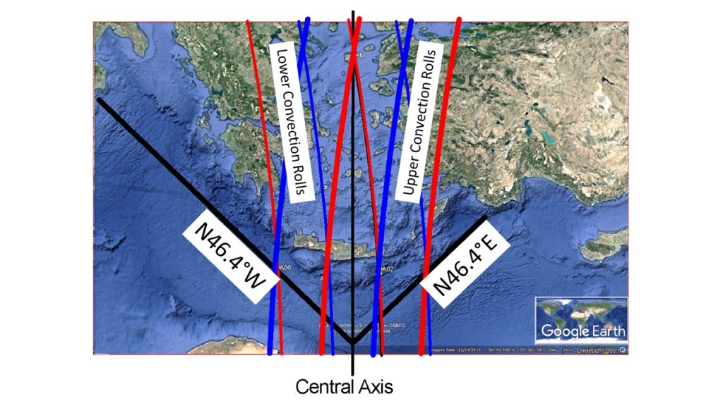
The Aegean Sea is a famous part of the Mediterranean, where the African Tectonic Plate meets with the Eurasian Tectonic Plate. Description of the geological features can be seen here: https://en.wikipedia.org/wiki/Aegean_Sea_Plate
Symmetry of the Aegean Sea
Apart from the deep understanding the Aegean Sea geology already found in scientific articles, the convection rolls pattern tells an untold story. The two trenches (Hellenic Trench and Strabo Trench) are accurately symmetrical, as shown here, aligned 46.4° from north. A closer look would lead to the conclusion that the edges sway a bit. The alignment can actually be pinpointed with calculation, being the alignment (from east and west respectively) of a tectonic roll of the relevant latitude divided with two. The central axis is formed in between convection rolls division lines, marked with intersection point of the northern part of the Sea.
The Mediterranean Sea is characterized by north-south oriented convection rolls, and along the 32nd parallel, the alignment er exactly N-S. This leads to the rather unique symmetry of the Aegean Sea.
The relevant convection rolls are shown superimposed on the Google Earth map. Red lines stand for upwelling between rolls, blue lines stand for downwelling. The upper set of rolls is drawn with slightly wider lines, the lower convection rolls have thinner lines for marking the divisions between them.
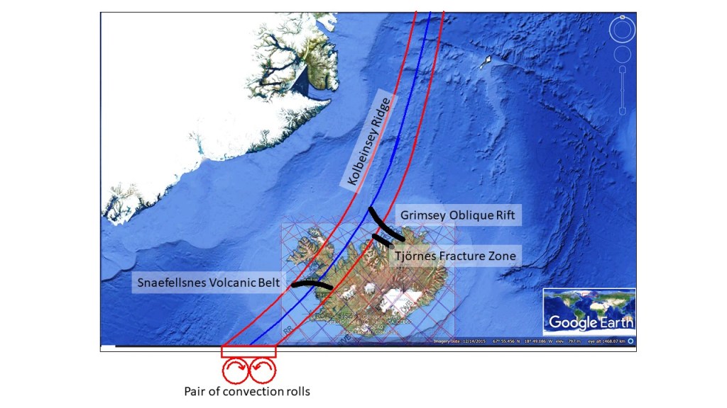
The Mid-Ocean Ridge north of Iceland is connected through the Grimsey Oblique Rift. Looking at the Google Map, with a convection rolls system map superimposed, the context becomes quite clear:
Connections between Kolbeinsey Ridge and geological features of Iceland
The pair of convection rolls extending north of Iceland follow the Kolbeinsey Ridge closely. The eastern convection roll also coincides with the northernmost part of Reykjanes Ridge. (The main part of the Reykjanes Ridge is then shaped by the convection rolls system extending from equator.) A certain aspect of the Tjörnes Fracture Zone is revealed here, namely that it connects the North Volcanic Zone divisional effect with the upwelling division line found north of Eyjafjordur. On the other hand, the Grimsey Oblique Rift extends to the downwelling line found at the eastern side of Kolbeinsey Ridge. This also reveals a certain difference between Kolbeinsey Ridge and the Reykjanes Ridge. Kolbeinsey Ridge resembles a volcanic zone in a way, because it follows a path in between two division lines of the convection rolls. The convection roll is thereby coupled to the tectonic plate, providing resistance to the main tectonic drift of the North American Tectonic Plate in the opposite direction. The Snaefellsnes Volcanic Belt extends over the two convection rolls, thereby also playing a role in the adjustments related to the Kolbeinsey Ridge.
The Kolbeinsey Ridge did break the Jan Mayen Microcontinent away from Eastern Greenland, and the northern end of the ridge is at the so-called Jan Mayen Fracture Zone, as can easily be detected on the map. That does not affect the convection rolls, as they are formed out of slowly flowing mantle material. The properties of convection rolls are quite special, as the mantle there is not molten, but not rigid either. The physical properties are balanced and quite stable, leading to a regular geological arrangement on the surface as well.
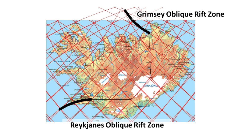
Similar oblique rift zones connect the Icelandic volcanic zones with the two mid-ocean ridges, Reykjanes Ridge and Kolbeinsey Ridge. When compared, the length of those two oblique zones appears to be exactly the same, and even the shape of them is alike. Considering that those areas have the same function, as they are reacting to similar effect of the tectonic drift, it is maybe not so strange. When compared to the convection rolls model, this picture emerges:
Identical (or mirrored) oblique rift zones
If put together, these zones form a triangle with three equal sides. The tilt of the triangle corresponds to the divisional vectors of tectonic drift in Iceland. The areas have the characteristics of both volcanic and seismic zones. Reykjanes Oblique Rift Zone is much better known, as it is largely found on land, but the part of it found offshore seems often to be neglected. Recently, more information has been gathered about the Grimsey Oblique Rift, often referred to as the Grimsey Lineament or the Grimsey Seismic Zone.
The end points of both oblique rift zones can be compared, as in the South, the main division line over Iceland is directly E-W oriented, whereas the end point in the North connects to a line directly N-S oriented. The other end points connects the zones with the regularly shaped mid-ocean ridges. The bending of the oblique zones takes place within the grid of polygons in a formidable way. Following the division between tectonic plates along the Reykjanes Ridge looks easy, as it follows one single line with a simple formula. Then is starts bending off the track, leading to the formation of Reykjanes Oblique Rift Zone. Then the E-W part takes over, with the South Iceland Seismic Zone and the East Volcanic Zone, respectively. Following the division along the eastern edge of the East Volcanic Zone leads us to the turning point at Kverkfjöll. Then we have a direct N-S line through the central axis of the North Volcanic Zone, all the way to the Öxarfjordur Bay, where a sharp turn is made for the Grímsey Oblique Rift. As has been dealt with in other posts, there are other faults of the Tjörnes Fracture Zone making the situation out of the north coast of Iceland more complicated, with a triple system of the Dalvik Lineament, Husavik-Flatey Lineament along with the Grímsey Lineament (here dealt with as Grímsey Oblique Rift Zone). From the end point, where a volcano called Storagrunn, the Zone is connected with Kolbeinsey Ridge, completing the main division line between the N-American Tectonic Plate and the Eurasian Tectonic Plate.