Öræfajökull Volcano can be said to be a corner-stone of the convection rolls system, as manifested in Iceland, due to its role as the keypoint for two different direct axis through Iceland. The North Volcanic Zone of Iceland trends directly northwards, and a sharp line can be drawn through the polygons appearing within the pattern formed by division lines of convection rolls of four different mantle layers.
The NS-axis of East Iceland
Various other volcanic and geothermal sites belong to the North Volcanic Zone, but here those happening to be located almost accurately on the NS-line are pointed out. The reason for this is highly mechanical, as the polygons tend to break up from one corner to the other when subject to horizontal pressure due to tectonic drift.
Öræfajökull and Kverkfjöll resemble each other, being placed at the edges of Vatnajökull Glacier. Askja and Hrúthálsar are similarly located centrally in the polygons. Krafla is located within a rather complicated hub of division lines, and the Öxarfjörður Geothermal Area is found at crossings at the seaside. it has long been a debate whether it is high temperature or low temperature area.
The 64th parallel in Iceland is a proof that Earth’s rotation has profound effect on topography, volcanism, geothermal and seismic activity of the globe. Here it is shown on a map in context with the division lines of convection rolls system:
The 64th Parallel in Iceland
In the western part, at the Reykjanes Peninsula we find a very interesting volcano, Thrihnukagigur, where you can enter a huge, emptied magma chamber. https://insidethevolcano.com/the-volcano/
South Iceland Seismic Zone: Then the whole area from Hveragerði Town to Hekla Volcano is defined as the South Iceland Seismic Zone. https://www.jonfr.com/volcano/?p=745
Landmannalaugar is a popular hot spring area, within the most powerful high temperature area of Iceland, the Torfajökull Area. In between the two points of Hekla and Laki, the East Volcanic Zone is found. https://en.wikipedia.org/wiki/Landmannalaugar
Laki Volcano is located within a long fissure, and is associeted with the Laki eruption which started in 1783, so fiercely that it is thought to have changed the history of the whole world. The magma of the eruption did flow from the Grímsvötn volcanic site, but Laki is actually older than that. The lava appeared on the surface when it crossed the division line found there, as seen on the map above. Laki is close to the eastern border of the East Volcanic Zone. https://en.wikipedia.org/wiki/Laki
Öræfajökull Volcano is the highest in Iceland. It is located on crossings of lines of different convection rolls layers. The existence of this mountain can then be explained, but without the convection rolls model, it is extremely difficult to find a reason for its location. https://en.wikipedia.org/wiki/%C3%96r%C3%A6faj%C3%B6kull
To travel along the 64th parallel, and the surrounding areas is interesting, and the fact that the convection rolls are regularly arranged exactly at that latitude, in the middle of the intersection zone of equatorial and polar parts of the convection rolls system, makes it so diverse and powerful.
Here, tectonic drift is compared with the convection rolls. The arrows do not show correct directions, only latitudinal trend. It is the first step to understand the relationship between large scale convection rolls and drift of the tectonic plates.
Tectonic Drift Latitudinal Trend and Convection Rolls Location of Lower Mantle
The difference between North and South Hemisphere, and the relative inactivity of Indian Ocean Ridge, should be studied specially.
This has to be compared to real drift vectors, shown here:
Real Tectonic Drift Directions According to GPS Measurements
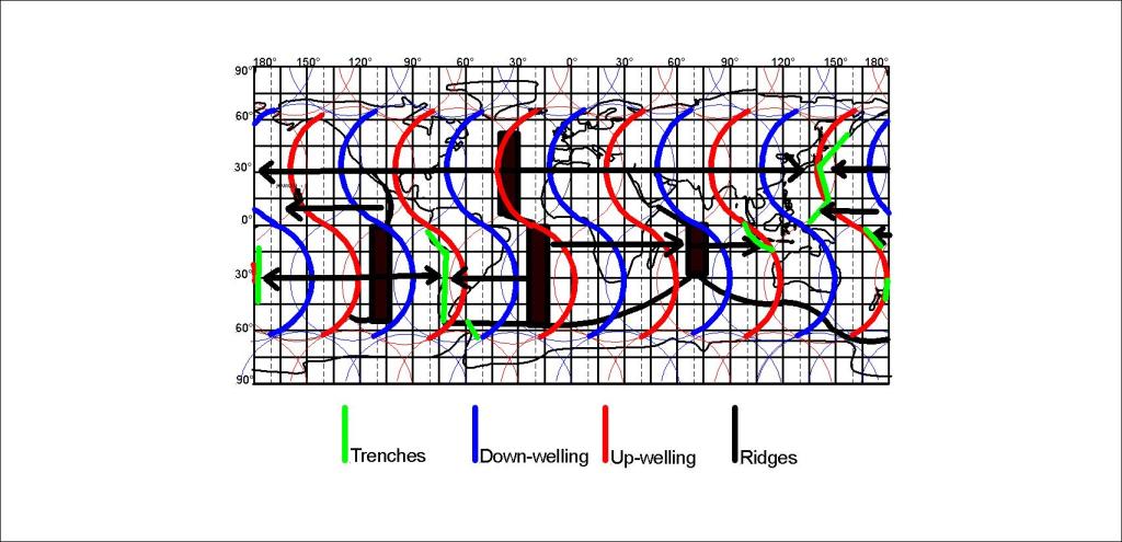
The consistency between both ridges and trenches on one hand and the convection rolls on the other hand can easily be seen. What becomes more difficult for us, is seeing how the system will develop as tectonic drift goes on, when it all looks fixed and we see the consistency between mantle currents and plate tectonics. It looks like if we move something, things would not fit any more! Still, it should become easier in the end, simply because these convection currents move the continents continually around.
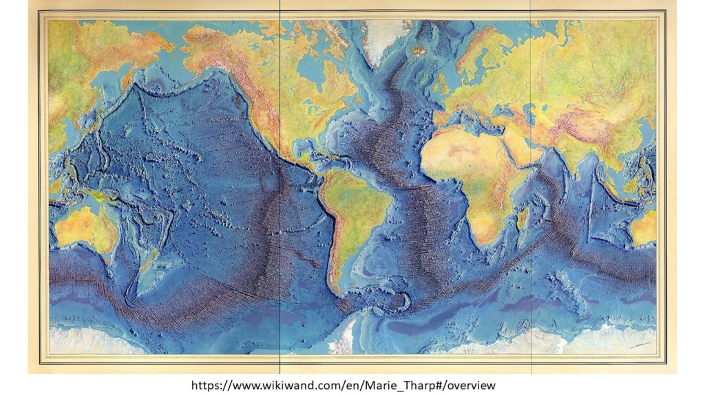
The mid ocean ridges can be compared with the convection rolls system. The original map looks like that:
The Mid Ocean Ridges mapped by Tharp and Heezen
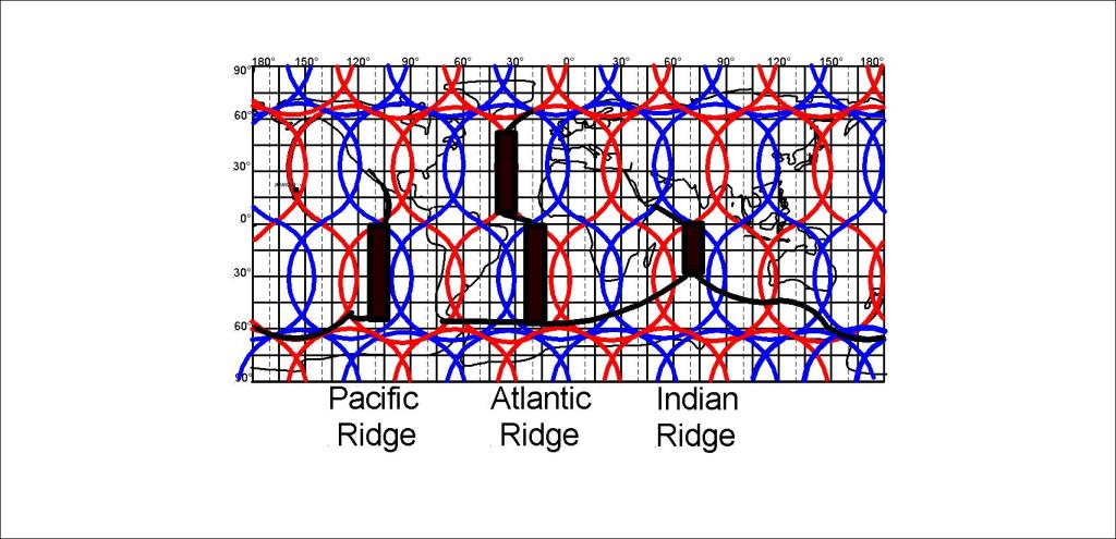
This can be compared with the convection rolls in a simple way:
Simplified Pattern of Mid Ocean Ridges
A more precise analysis, down to the 1.5° accuracy level, reveals much more, as shown for instance for the Reykjanes Ridge, barely noticeable on this World Map. The Reykjanes Ridge follows a division line exactly.
A profound difference is found between the North Atlantic Ridge and the South Atlantic Ridge. The North Atlantic Ridge is found along a up-welling line, but the South Atlantic Ridge is found in between the lines. A pattern of three ridges, for the Pacific, S-Atlantic and Indian Ocean, in harmony with the 30° divisions between convection rolls, appears,
The large Pacific Plate covers several large scale convection rolls, so the reaction to opposite flow of mantle must be understood. The answer is coupling and de-coupling process with the upper-most rolls. Similar process is known at the bottof of glaciers, sliding over un-even ground. The ice melts when meeting with upheavals, then it does freeze at the other end with less fraction, and then ‘plucks’ the rock below. The process of tectonic plate sliding from east to west, is exactly the same with 1.5° interval. Besides that, every 30° some other change generally occurs, due to a different large scale trend associated with the 30° E-W units of lower mantle rolls.
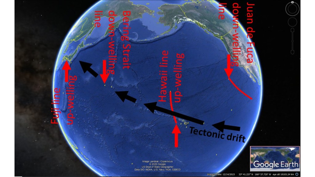
The Drift Direction of Pacific Tectonic Plate
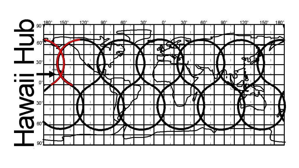
The volcanic activity resulting when the Pacific Tectonic Plate reaches the main division line, or more accurately the 6° interval of small scale upper rolls east of the main line, shows the local trend of inducing opposite tectonic drift to the main drift. Also, a hub of the convection rolls system is found at this location.
Hawaii Hub of Convection Rolls System of Up-welling Lines
As can be seen, all the up-welling lines are in fact connected into one wholistic system. The Polar Parts are omitted here. The implications of the hub provede an extra pressure/weakness to the area of the Hawaii Islands. Still, do not forget the other factor, horizontal tectonic drift, being opposed east of the red lines of Hawaii.
The 8-formed loops might be difficult to understand at first, as the large scale convection rolls only represent half of that arrangement. The other half of each 8-form is represented on one hand by the small scale rolls found between 265-410 km depth, and on the other hand by the outer core. Traces of core material can therefore be found in magma of countries like Hawaii and Iceland.