The Reykjanes Ridge and Kolbeinsey Ridge form a rather regular division line between tectonic plates, south and north of Iceland. In between the pattern is more complex. As for the convection rolls below, they are in a way more complex under Iceland, due to the transit zone of polar and equatorial convection rolls.
The two systems meet at 64°N, and both are subject to the same mathematical formula. If we trace the Reykjanes Ridge Convection Rolls, we find this picture:
If the Reykjanes Ridge is supposed to have convection rolls at each side, then they can be extrapolated farther. The mantle is half molten and does not behave like the rigid surface. Therefore, the convection rolls must be continuous. Then, the same shape must prevail all the way.
Mid Atlantic Ridge Convection Rolls Division Line
The Mid Atlantic Ridge itself makes some side-jumps, and is swaying a bit irregularly. Still, the calculated convection rolls division line does cross the ridge itself at 32°N and at equator. This is something to think about, because the system is found to converge around 32°N, whereas the convection rolls there are oriented exactly north-south. At 0°, the fact that horizontal flow Coriolis effect shifts from right hand turn to left hand turn, explains the consistency of distance between main topographic features. In this case, the distance from center of Atlantic is exactly 30° to both S-America and Africa. That means of course, that the width from coast to coast of the Atlantic Ocean along equator is exactly 60°. Not strange, because each convection roll of lower mantle spans 30° from east to west.
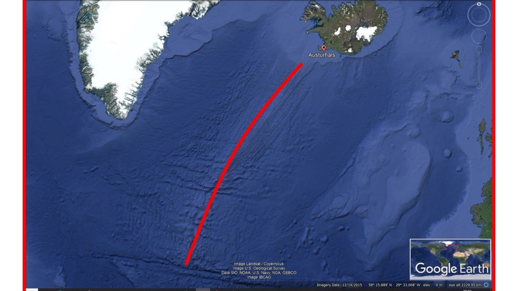
The largest feature of Iceland is indeed the Reykjanes Ridge. But it is below the ocean so we can not see it directly. It shows that two mantle currents must be pulling the ocean apart, and it is also clear that those are convection currents. These currents must be long, and it means they have to be convection rolls.
The Reykjanes Ridge
It is also logical that the convection rolls do not end where the red line ends. Therefore the full 3D analysis of the mantle currents has been made to explain the different features found on the surface. The geology of Iceland is quite complicated, partly because it is found within the intersection zone of different layers of convection rolls. The simplicity and regularity of the Reykjanes Ridge is helpful for us to derive the whole system and understand the basics of the convection rolls system of Earth’s mantle.
Lagarfljót River is found outside the volcanic areas of Iceland. The tectonic origins can still be traced to the Snæfell area, and the river follows the same alignment formula as the Reykjans Ridge, that is the mantle rolls extending from equator.
Lagarfljót Polygons
We can then analyse the Lagarfljót River according to the relevant polygons. Polygon 1 does comprise the origins at Vatnajökull, Snæfell and the upper most reaches. Then the valleys of polygon 2. Polygon 3 makes up the central part of the river. In polygon 4 it makes a sharp turn to the north, and flows along the NS-axis to the north corner of the polygon. The tension is then over, and the river makes a wide turn to the east towards the ocean.
Red lines show up-welling, so there is clearly opposite flow compared to main drift (the east- west component of main drift vectors) of Eurasian plate found locally.
The main tourist attractions near Reykjavík have been explained here. This map shows the location slightly more accurately:
The main tourist attractions near Reykjavík
Þingvellir on the NS-axis of the south polygon of West Volcanic Zone, Reykholt on the upwelling line extending from Reykjanes Ridge, Deildartunga on the EW-axis extending from the mini-polygon of Reykholtsdalur, Hraunfossar on the other up-welling line from RR, close to the east corner of the mini-polygon, Hveragerði on the main crossings of lines, Laugarvatn found on two down-welling upper lines, also above the main division line of lower mantle, Geysir on the down-welling line extending to the NW from Hekla, slightly offset from the main division line of lower mantel, Gullfoss found at the upper part of a gorge, which extends to the lowlands, actually marked by the down-welling division lines of Hekla-Geysir-Reykholtsdalur.
By zooming in on the places and studying the geological framework, the consistency between convection rolls division lines and the tourist attractions becomes clearer.